Rennofen
Location: Nettersheim
Website: https://archaeologischer-landschaftspark.de/erkennen/eisenverhuettung.html
Website: https://archaeologischer-landschaftspark.de/erkennen/eisenverhuettung.html
GPS coordinates: 50.48570,6.62732
Latest update: November 19, 2025 14:35

Marcomagus
990 m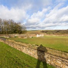
Görresburg
747 m
Herz-Jesu-Kloster
1.2 km
St. Martin
816 m
Naturzentrum Eifel
460 m
Burg Nettersheim
898 m
Alte Burg (Nettersheim)
771 m
Schleifbachtal südwestlich Nettersheim
966 m
Jüngere Burg
705 m
Dallwegen südlich Nettersheim
867 m
Unteres Genfbachtal
1.3 km
Kunst Schau Raum Cisa
441 m
Wayside cross
191 m
Kleinkastell
1 km
Fossilienacker
244 m
Via Agrippa
710 m
Blick über Nettersheim
478 m
SternenBlick Zeitreise
779 m
Werkplatz Steinrütsch
1 km
Wayside cross
608 m
Streifenhäuser Via Agrippa
771 m
Via Agrippa - Ausgrabung
783 m
Wayside cross, Christianity, Catholic church building
1 km
Wayside cross, Christianity, Catholic church building
797 m
Weihestein
757 m
Weihestein
756 m
Weihestein
753 m
Weihestein
750 mReviews
Visited this place? Tap the stars to rate it and share your experience / photos with the community! Try now! You can cancel it anytime.
Discover hidden gems everywhere you go!
From secret cafés to breathtaking viewpoints, skip the crowded tourist spots and find places that match your style. Our app makes it easy with voice search, smart filtering, route optimization, and insider tips from travelers worldwide. Download now for the complete mobile experience.

A unique approach to discovering new places❞
— Le Figaro
All the places worth exploring❞
— France Info
A tailor-made excursion in just a few clicks❞
— 20 Minutes