
Bunker der ehemaligen Sendestelle des Regierungsbunkers Ahrweiler
Bunker der ehemaligen Sendestelle des Regierungsbunkers Ahrweiler
Location: Stotzheim
Location: Euskirchen
Operator: Forstbetrieb D&C Koppenburg GbR
Opening Hours: "nach Anmeldung"
GPS coordinates: 50.60981,6.80754
Latest update: November 20, 2025 17:47
Hardtburg
662 m
Aquäduktbrücke über die Erft
1.6 km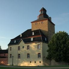
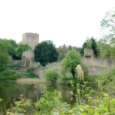
Burg Kirspenich
1.4 km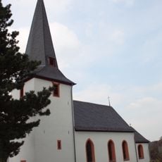
Heilig-Kreuz
1.2 km
Hubertusstraße 2
1.1 km
Erftal zwischen Kreuzweingarten und Stotzheim
1.4 km
LSG-Alter Burgberg und Hardt
500 m
St. Bartholomäus
1.2 km
Watzenberg
1.1 km
LSG-Strukturreiche Kulturlandschaft oestlich Arloff und Kirspenich
1.3 km
Wayside cross
1.3 km
Wayside cross
926 m
Scenic viewpoint
873 m
Hubertuskreuz
452 m
Gasthaus zum alten Brauhaus
1.1 km
Pestkreuz
1.1 km
Kreuzweingartener Erftmadonna
1.1 km
Römische Wasserleitung
1.4 km
Wayside shrine
1.6 km
Keramikatelier Günther
1.3 km
Wayside shrine
1.1 km
Kriegerehrenmal
1.2 km
Wayside cross
1.4 km
Wayside cross
1.6 km
Archaeological site
1.3 km
Catholic church building, wayside cross, Christianity
800 m
3 Segmente der Berliner Mauer
1.4 km
Wayside cross
1.2 kmReviews
Visited this place? Tap the stars to rate it and share your experience / photos with the community! Try now! You can cancel it anytime.
Discover hidden gems everywhere you go!
From secret cafés to breathtaking viewpoints, skip the crowded tourist spots and find places that match your style. Our app makes it easy with voice search, smart filtering, route optimization, and insider tips from travelers worldwide. Download now for the complete mobile experience.

A unique approach to discovering new places❞
— Le Figaro
All the places worth exploring❞
— France Info
A tailor-made excursion in just a few clicks❞
— 20 Minutes