Mirusha Waterfall
Location: Komuna e Klinës / Opština Klina
GPS coordinates: 42.52382,20.58247
Latest update: November 23, 2025 22:55
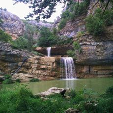
Miruša Waterfalls
44 m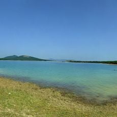
Radoniq Lake
14.1 km
Monastère de Dobra Voda
13.2 km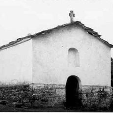
Church of St. Paraskeva, Drsnik
8.4 km
Zatrič
9.8 km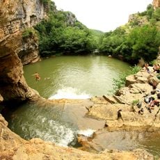
Mirusha Park
42 m
Guri i Zi
2.4 km
Bajrak (tumoy sa bukid sa Kosobo, lat 42,40, long 20,57)
14 km
Mirusha Waterfall
155 m
Garačevska Kula
8.2 km
Mala Ostrika
4 km
Uljarica (langub)
69 m
Koznik (tumoy sa bukid)
4.7 km
Gola Brda
4.8 km
Споменик природе „Извор минералне воде „Бања“ у селу Дрсник“
9.5 km
Gojleš Moliševski
13.2 km
Споменик природе „Део клисуре реке Клина“
11.2 km
Çifllak
8.4 km
Vran Stena
13.2 km
Mirusha Waterfall
66 m
ANSH Architecture
12.9 km
Rigjev , shpia
11.3 km
Rigjev te shpia
11.3 km
Ura e KLINES
7.6 km
Anton Qeta
10.7 km
Mujë Krasniqi
10.6 km
Scenic viewpoint
47 m
Ujëvara
276 mReviews
Visited this place? Tap the stars to rate it and share your experience / photos with the community! Try now! You can cancel it anytime.
Discover hidden gems everywhere you go!
From secret cafés to breathtaking viewpoints, skip the crowded tourist spots and find places that match your style. Our app makes it easy with voice search, smart filtering, route optimization, and insider tips from travelers worldwide. Download now for the complete mobile experience.

A unique approach to discovering new places❞
— Le Figaro
All the places worth exploring❞
— France Info
A tailor-made excursion in just a few clicks❞
— 20 Minutes