Mile 0 Alaska Highway
Location: Dawson Creek
Opening Hours: Maandag-Zondag 00:00-23:59
GPS coordinates: 55.75886,-120.22511
Latest update: November 5, 2025 01:05

Taylor Bridge
50.5 km
Peace River Suspension Bridge
50.6 km
Moonshine Lake Provincial Park
64.5 km
One Island Lake Provincial Park
50.5 km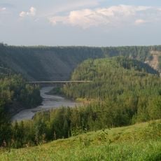
Kiskatinaw Provincial Park
30.8 km
East Pine Provincial Park
62.3 km
Swan Lake Provincial Park
28.6 km
Beatton River Provincial Park
39.1 km
Taylor Landing Provincial Park
50.1 km
Peace River Corridor Provincial Park
38.3 km
Dunvegan West Wildland Provincial Park
62.2 km
All Saints Anglican Church
51 km
Immanuel Evangelical Lutheran Church
62.4 km
Rolla Canyon Ecological Reserve
19.2 km
Kiskatinaw River Provincial Park
39 km
Clayhurst Ecological Reserve
44.3 km
Fort St. John
45.5 km
Ronning Homestead
64.8 km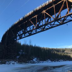
Kiskatinaw River Bridge
30.6 km
Lone Wolf Golf Course
53 km
Dawson Creek Golf & Country Club
3.2 km
Farmington Fairways
15.4 km
Alaska Highway Mile 0 Milepost
232 m
Dawson Creek Art Gallery
118 m
Cherry Blossom Tree
63.8 km
Statue, Work of art
50.2 km
Trestle
7.4 km
Peace River Lookout
63.3 kmReviews
Visited this place? Tap the stars to rate it and share your experience / photos with the community! Try now! You can cancel it anytime.
Discover hidden gems everywhere you go!
From secret cafés to breathtaking viewpoints, skip the crowded tourist spots and find places that match your style. Our app makes it easy with voice search, smart filtering, route optimization, and insider tips from travelers worldwide. Download now for the complete mobile experience.

A unique approach to discovering new places❞
— Le Figaro
All the places worth exploring❞
— France Info
A tailor-made excursion in just a few clicks❞
— 20 Minutes