Route 66 mid point
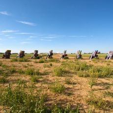
Cadillac Ranch
63.1 km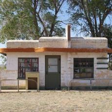
Glenrio
35.1 km
Landergin Mesa
36.7 km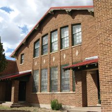
Nara Visa School
54.3 km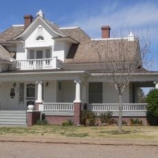
Deaf Smith County Historical Museum
56.2 km
Channing United Methodist Church
55.3 km
Sand Point
35.5 km
Bivins Lake
63.5 km
Hartley County Courthouse and Jail
55.1 km
Whale Pond
59.2 km
Pescado Creek Lake
50.9 km
XIT Ranch Headquarters
55.7 km
Tascosa Courthouse, 1884.
47.7 km
The E. B. Black Residence
56.4 km
Adrian water tower
821 m
Deaf Smith Courthouse, 1910
56.3 km
XIT General Office
55.6 km
Hereford High School
55.9 km
John Pitman Golf Club
57 km
John Pitman Golf Club
57.1 km
DOTS Mini Museum Route 66
22.1 km
Magnolia Gas Station
22.9 km
Second Amendment Cowboy
64.2 km
Little Juarez Cafe (Abandoned)
34.9 km
Abandoned Texaco Station
34.9 km
Abandoned Glenrio Post Office
35.4 km
Statue, Work of art
47.7 km
Marshall Cator
47.3 kmReviews
Visited this place? Tap the stars to rate it and share your experience / photos with the community! Try now! You can cancel it anytime.
Discover hidden gems everywhere you go!
From secret cafés to breathtaking viewpoints, skip the crowded tourist spots and find places that match your style. Our app makes it easy with voice search, smart filtering, route optimization, and insider tips from travelers worldwide. Download now for the complete mobile experience.

A unique approach to discovering new places❞
— Le Figaro
All the places worth exploring❞
— France Info
A tailor-made excursion in just a few clicks❞
— 20 Minutes