Chest opened
+${chestReward.xp} XP
Explorer
NOUVEAU ×${chestReward.collectible.quantity}
tapez pour fermer
Chest locked

Open chests in the app

Around Us is built for your phone — chests unlock when you walk, explore and capture nearby places.

Enable Location

We need your location to show you interesting places around you

Discover nearby places

Find interesting locations and hidden gems around you

Precise directions

Get accurate directions and distances to places

Your location is never shared with other users. It's only used when you tap the location button.

Log in to your account

Start exploring — it's free

Trusted by 73,106 travelers worldwide

Continue with Google
Continue with Apple
or

We will send you a code to connect

By continuing, you accept our Terms and Conditions and our Privacy Policy

Check your inbox

We've sent a pincode in your inbox. Please enter the code below.

The Bridle Track, New South Wales
Discussion Reviews Photo
3.9k Popularity

The Bridle Track, New South Wales, Historic trail between Bathurst and Hill End, New South Wales, Australia

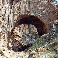
The Bridle Track is a historic overland route in New South Wales that connects Bathurst to the former gold mining area around Hill End, running close to the Macquarie River for much of its length. The terrain alternates between river flats, wooded slopes, and open ridgelines.

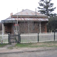
The track was established in the 1800s to serve the flood of miners and traders heading to the gold fields near Hill End, giving them a direct link to the regional centre of Bathurst. Over time, as the gold rush faded, the route lost much of its traffic and parts of it fell into disuse.

Along the route, the remains of old mining settlements are still visible, with stone foundations, collapsed shafts, and overgrown yards that hint at what once stood there. Passing through these areas gives a sense of how tightly daily life was tied to the work of extracting gold from the ground.

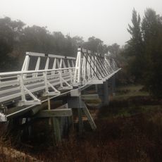
Much of the route can be driven by vehicle, though some sections are unsealed roads that may be rough or muddy after rain. Checking current conditions before setting out is a good idea, especially outside dry summer months.

Large sections of the route were blocked for over a decade by landslides and only recently became passable again. This means that many visitors today are among the first in years to travel the full length of the track as it was originally used.

The community of curious travelers

AroundUs brings together thousands of curated places, local tips, and hidden gems, enriched daily by 60,000 contributors worldwide.

Start exploring
Location
GPS coordinates
-33.03333,149.41667
Latest update
March 3, 2026 14:05
Reviews
Share your experience

No review yet

Discussions
Start a discussion...

No discussion yet

« The Bridle Track, New South Wales - Historic trail between Bathurst and Hill End, New South Wales, Australia » is provided by Around Us (aroundus.com). Images and texts are derived from Wikimedia project under a Creative Commons license. You are allowed to copy, distribute, and modify copies of this page, under the conditions set by the license, as long as this note is clearly visible.

Discover hidden gems everywhere you go!

From secret cafés to breathtaking viewpoints, skip the crowded tourist spots and find places that match your style. Our app makes it easy with voice search, smart filtering, route optimization, and insider tips from travelers worldwide. Download now for the complete mobile experience.

Around Us App Screenshot

A unique approach to discovering new places

Le Figaro

All the places worth exploring

France Info

A tailor-made excursion in just a few clicks

20 Minutes

Around Us
Travel Guide & Maps
Download

Send to your phone

QR Code
1

Open the camera app on your mobile.

2

Point at the QR code with your camera. A notification will appear.

3

Tap the notification to open the link.