Casas de Santana

Log in to your account

AroundUs is a community-driven map of interesting places, built by curious explorers like you. It grows with every review, story, and photo you share.
Connect to save your favorite spots, contribute locations, and create personalized routes.
By continuing, you accept our Terms and Conditions and our Privacy Policy

Casas de Santana

Add to collection
Map
Suggest a change
Share

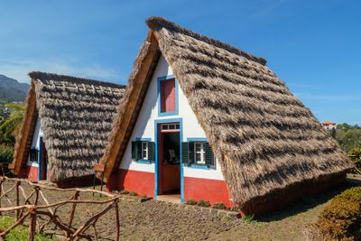
Casas de Santana, Traditional triangular houses in Santana, Portugal

Casas de Santana are traditional dwellings in Santana, Madeira, Portugal, recognizable by their triangular shape with thatched roofs that slope down almost to the ground. The facades display bold colors such as blue, red, and white, with each house featuring individual patterns and wooden cladding that shield the structure from wind and rain.

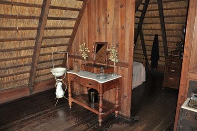
Settlers built these houses starting in the 16th century using wood and cereal stalks, both readily available in the region and suited to the damp climate. Over time, many were demolished or rebuilt, but some survived and now serve as a museum to show building methods from the past.

Families lived on the ground floor, using one room for cooking and another for sleeping, while storing grain and tools in the attic space above. The name Santana honors Saint Anne, patron of the area, whose devotion shaped many local customs and festivals still observed today.

The site is open during the day and allows visitors to walk through several restored buildings, with information panels offering insights into construction methods. The paths are mostly level, though visitors should watch their step in wet weather as grass can become slippery.

The triangular shape creates natural air circulation that cools in summer and retains warmth in winter without additional heating or cooling systems. The steep angle lets rainwater run off quickly, preventing the thatch from rotting or becoming heavy with moisture.

Location: Santana

Address: 9230-082 Santana, Portugal

GPS coordinates: 32.80526,-16.88241

Latest update: December 5, 2025 22:27

Photos
Madeira tour: gardens, viewpoints, mountains

This collection covers the main natural areas and cultural sites across Madeira, a Portuguese island of volcanic origin in the Atlantic Ocean. The route connects coastal regions with highland areas, showcasing the diverse vegetation that results from the subtropical climate and varied elevation levels. Included locations feature Pico Ruivo, the island's highest peak at 1,861 meters, the sea cliffs at Cabo Girão, the botanical gardens of Funchal with plant collections from multiple continents, and several coastal and mountain viewpoints. The route also incorporates examples of traditional levada irrigation channels, which have distributed water across the island for centuries.

Reviews

Visited this place? Tap the stars to rate it and share your experience / photos with the community! Try now! You can cancel it anytime.

« Casas de Santana - Traditional triangular houses in Santana, Portugal » is provided by Around Us (aroundus.com). Images and texts are derived from Wikimedia project under a Creative Commons license. You are allowed to copy, distribute, and modify copies of this page, under the conditions set by the license, as long as this note is clearly visible.

Discover hidden gems everywhere you go!

From secret cafés to breathtaking viewpoints, skip the crowded tourist spots and find places that match your style. Our app makes it easy with voice search, smart filtering, route optimization, and insider tips from travelers worldwide. Download now for the complete mobile experience.

Around Us App Screenshot

A unique approach to discovering new places

Le Figaro

All the places worth exploring

France Info

A tailor-made excursion in just a few clicks

20 Minutes