Min Min Encounter Centre
Location: Boulia
Location: Boulia Shire
GPS coordinates: -22.91171,139.91117
Latest update: November 26, 2024 21:12
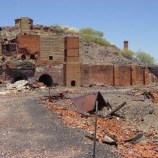
Mount Elliott Mining Complex
165.2 km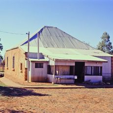
Boulia Stone House
405 m
Great Artesian Basin Springs: Elizabeth
83.8 km
Time Capsule Boulia Shire
91 km
Site of Min Min Hotel
100.7 km
SIte of Police Barracks 1875-1884
24.7 km
The Legend of Min Min Light
41.2 km
Eddie Miler Rest Area - Boulia Point of Interest
61.4 km
Tropic of Capricorn
66.1 km
Tropic of Capricorn
66.1 km
Hamilton Hotel Ruins
72.1 km
Boulia Golf Club
2.1 km
ANZAC 100TH ANNIVERSARY
91 km
Kooree Yuppiree Waddi Tree Corroboree Ground
533 m
Vaughan Johnson Lookout
91 km
Scenic viewpoint
91 km
Acacia Puece Waddi Trees
17.2 km
Legend of Min Min Light
100.8 km
Scenic viewpoint
130 km
Cawnpore Lookout
132.2 km
Qld Main Roads
141.4 km
Jalanga and Kalkadoon People Site
146.5 km
Cobb and Co Marker No 5 : Makunda Hotel
149.6 km
Janet's Leap
150.9 km
Scenic viewpoint
151.1 km
The zoo
158.1 km
Cannington Mine - Commemoration Plaque
159.1 km
Mount Elliot Mine and Smelter
164.4 kmReviews
Visited this place? Tap the stars to rate it and share your experience / photos with the community! Try now! You can cancel it anytime.
Discover hidden gems everywhere you go!
From secret cafés to breathtaking viewpoints, skip the crowded tourist spots and find places that match your style. Our app makes it easy with voice search, smart filtering, route optimization, and insider tips from travelers worldwide. Download now for the complete mobile experience.

A unique approach to discovering new places❞
— Le Figaro
All the places worth exploring❞
— France Info
A tailor-made excursion in just a few clicks❞
— 20 Minutes