Josef Ružička
Location: Općina Končanica
GPS coordinates: 45.63811,17.16486
Latest update: November 20, 2025 01:53
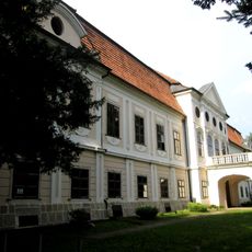
Daruvar Castle
6.4 km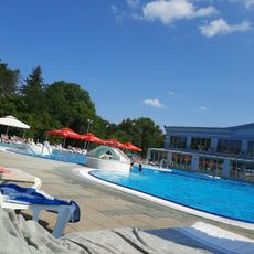
Termalni vodeni park Aquae Balissae
6.5 km
Tüköry-kastély
3.3 km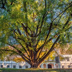
Gingko tree from Daruvar
6.4 km
Gradina Zdenci
6.4 km
Memorial
6 km
Antunova Kupka
6.8 km
Pajo Orozović Brko
6.5 km
Vatroslav Lisinski
6.8 km
NOB Donja Rašenica
5.2 km
Spomenik Braniteljima Daruvara
6.4 km
Spomenik Braniteljima
6.5 km
Benediktinska opatija Sveta Jelena de Podborje
6.7 km
Spomenik poginulim borcima NOB
6.5 km
Ždral
6.7 km
Švicarska vila
6.8 km
Raspelo iz 1931. godine
6.6 km
Spomen-ploča tisućite godišnjice Hrvatskog kraljevstva
6.6 km
NOB Daruvarski Brestovac
3.5 km
Raspelo
3.5 km
Kameni križ 1907. godine
6.8 km
Spomenik NOB Končanica
10 m
Spomenik braniteljima Končanica
8 m
Memorial, commemorative plaque
11 m
Raspelo
112 m
Spomen-ploča Josipu Ružičkom
2.4 km
Waterfall
6.5 km
Waterfall
6.5 kmReviews
Visited this place? Tap the stars to rate it and share your experience / photos with the community! Try now! You can cancel it anytime.
Discover hidden gems everywhere you go!
From secret cafés to breathtaking viewpoints, skip the crowded tourist spots and find places that match your style. Our app makes it easy with voice search, smart filtering, route optimization, and insider tips from travelers worldwide. Download now for the complete mobile experience.

A unique approach to discovering new places❞
— Le Figaro
All the places worth exploring❞
— France Info
A tailor-made excursion in just a few clicks❞
— 20 Minutes