Szent László király
Location: Kalocsa
Creator: Simor Márton
Creator: Simor Márton
GPS coordinates: 46.53164,18.97282
Latest update: November 20, 2025 03:48
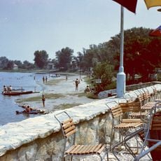
Lake Szelid
12.5 km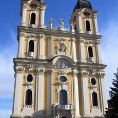
Assumption Cathedral
194 m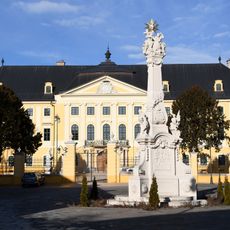
Archiepiscopal Palace in Kalocsa
124 m
Haynald Observatory
279 m
Viski Károly Múzeum
516 m
Our Lady of Hungary Church, Dunapataj
12.5 km
Szentlélek templom (Paks)
13.1 km
Kubikos szobor
667 m
Solt fejedelem
57 m
Sármégy templomrom
11.3 km
Faun vontató
11.1 km
Bakod Puszta Farm Show
8.2 km
Kalocsai Uszoda és Gyógyfürdő
1.3 km
Nagy strand
11.7 km
Vadászkápolna
11.2 km
A Hazáért!
5 km
Integetőszobor
1.5 km
Árpád fejedelem
104 m
Harangláb
6.2 km
Chronos 8
1.3 km
Statue, Work of art
1.1 km
Statue, Work of art
13.1 km
Szentháromság-szobor
185 m
Asztrik-szobor
224 m
Liszt Ferenc-szobor
170 m
Kajak-kenu céltorony
13 km
Waterfall
298 m
Nagy-éri csatorna géderi zsilip
8.1 kmReviews
Visited this place? Tap the stars to rate it and share your experience / photos with the community! Try now! You can cancel it anytime.
Discover hidden gems everywhere you go!
From secret cafés to breathtaking viewpoints, skip the crowded tourist spots and find places that match your style. Our app makes it easy with voice search, smart filtering, route optimization, and insider tips from travelers worldwide. Download now for the complete mobile experience.

A unique approach to discovering new places❞
— Le Figaro
All the places worth exploring❞
— France Info
A tailor-made excursion in just a few clicks❞
— 20 Minutes