Pont des Tuves

Log in to your account

AroundUs is a community-driven map of interesting places, built by curious explorers like you. It grows with every review, story, and photo you share.
Connect to save your favorite spots, contribute locations, and create personalized routes.
By continuing, you accept our Terms and Conditions and our Privacy Policy

Pont des Tuves

Add to collection
Map
Suggest a change
Share

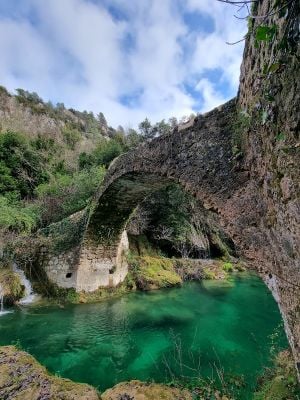
Pont des Tuves, Historic stone bridge trail in Montauroux, France

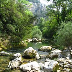
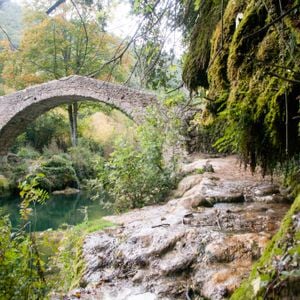
The Pont des Tuves is a stone bridge with a single arch spanning 20 meters across the Siagne River, featuring a paved pathway of 1.7 meters width and connecting the Var and Alpes-Maritimes departments through forested terrain.

This bridge was reconstructed in 1802 on the remains of an ancient Roman crossing that served as a commercial route for caravans transporting wheat, oil, and flour to Fréjus during the Roman era.

The structure represents traditional Genoese stone architecture and has served for centuries as the primary passage between Montauroux and Saint-Cézaire, playing an important role in regional exchanges and local community connections.

The trail starts at the Stade du Défens parking area, covers approximately 4 kilometers round trip with 320 meters of elevation change, and takes about two and a half hours to complete on well-marked paths.

The bridge derives its name from the surrounding tufa rock formations created by calcium deposits from springs along the river's left bank, giving the water its distinctive turquoise color.

Location: Montauroux

Address: Chemin des Tuves, 06530 Montauroux, France 06530 Montauroux

GPS coordinates: 43.64350,6.79072

Latest update: November 23, 2025 16:11

Hiking along the French Riviera: Coastal paths between Nice and Monaco, from Cap d'Ail to the Gorges du Verdon

Between Nice and Monaco, coastal trails provide the opportunity to explore the Mediterranean coastline through various routes. The Cap d'Ail Coastal Path, Nietzsche's Path in Èze with 400 meters of elevation gain, and the Mont Boron Park in Nice with its 11 kilometers of marked trails allow exploration of the region from different perspectives. These routes alternate between seaside sections and uphill segments, offering views over the coast and inland areas. The geological diversity of the region is evident in the limestone cliffs lining the Route des Crêtes between La Ciotat and Cassis, the rock formations of Cap d'Ail, and the red rocks of the Esterel Massif. Further inland, the Verdon Gorges feature a canyon 700 meters deep, while the Mercantour National Park houses the Sentier des Géants within its ancient forest. The historical heritage marks these routes: the Nice Observatory on Mont Gros dates from the 19th century, Fort La Revere overlooks the coast from 696 meters altitude, and Saint-Honorat Island preserves its active monastery. These trails serve as direct accesses to the nature and history of the French Riviera.

Reviews

Visited this place? Tap the stars to rate it and share your experience / photos with the community! Try now! You can cancel it anytime.

« Pont des Tuves: Historic stone bridge trail in Montauroux, France » is provided by Around Us (aroundus.com). Images and texts are derived from Wikimedia project under a Creative Commons license. You are allowed to copy, distribute, and modify copies of this page, under the conditions set by the license, as long as this note is clearly visible.

Discover hidden gems everywhere you go!

From secret cafés to breathtaking viewpoints, skip the crowded tourist spots and find places that match your style. Our app makes it easy with voice search, smart filtering, route optimization, and insider tips from travelers worldwide. Download now for the complete mobile experience.

Around Us App Screenshot

A unique approach to discovering new places

Le Figaro

All the places worth exploring

France Info

A tailor-made excursion in just a few clicks

20 Minutes