See the monuments around you in AROpen chests in the app
Around Us is built for your phone — point your camera at the streets and discover the monuments and places around you in augmented reality.Around Us is built for your phone — chests unlock when you walk, explore and capture nearby places.
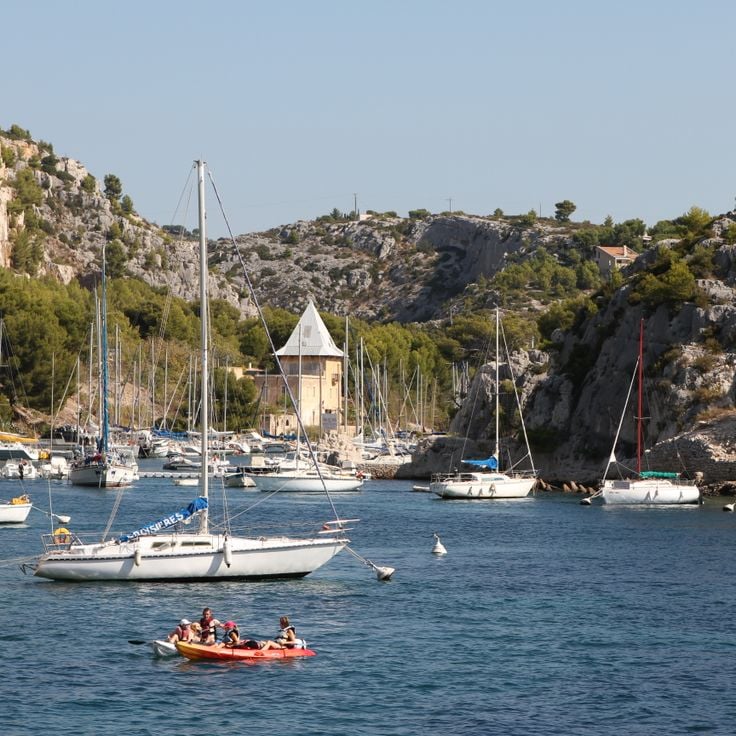
Hiking along the French Riviera: Coastal paths between Nice and Monaco, from Cap d'Ail to the Gorges du Verdon
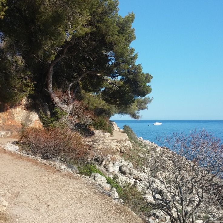
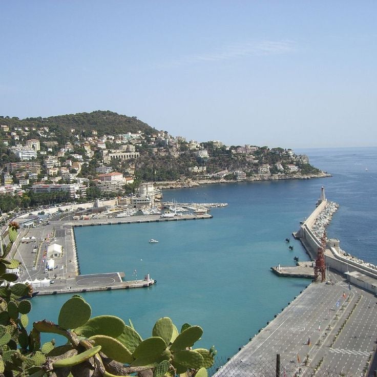
Between Nice and Monaco, coastal trails provide the opportunity to explore the Mediterranean coastline through various routes. The Cap d'Ail Coastal Path, Nietzsche's Path in Èze with 400 meters of elevation gain, and the Mont Boron Park in Nice with its 11 kilometers of marked trails allow exploration of the region from different perspectives. These routes alternate between seaside sections and uphill segments, offering views over the coast and inland areas.
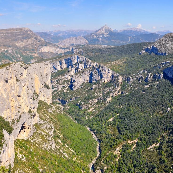
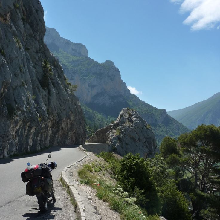
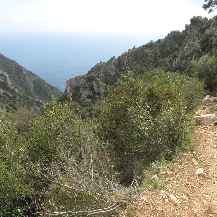
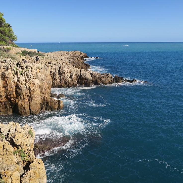
The geological diversity of the region is evident in the limestone cliffs lining the Route des Crêtes between La Ciotat and Cassis, the rock formations of Cap d'Ail, and the red rocks of the Esterel Massif. Further inland, the Verdon Gorges feature a canyon 700 meters deep, while the Mercantour National Park houses the Sentier des Géants within its ancient forest. The historical heritage marks these routes: the Nice Observatory on Mont Gros dates from the 19th century, Fort La Revere overlooks the coast from 696 meters altitude, and Saint-Honorat Island preserves its active monastery. These trails serve as direct accesses to the nature and history of the French Riviera.
Hiking along the French Riviera: Coastal paths between Nice and Monaco, from Cap d'Ail to the Gorges du Verdon
Between Nice and Monaco, coastal trails provide the opportunity to explore the Mediterranean coastline through various routes. The Cap d'Ail Coastal Path, Nietzsche's Path in Èze with 400 meters of elevation gain, and the Mont Boron Park in Nice with its 11 kilometers of marked trails allow exploration of the region from different perspectives. These routes alternate between seaside sections and uphill segments, offering views over the coast and inland areas.
The geological diversity of the region is evident in the limestone cliffs lining the Route des Crêtes between La Ciotat and Cassis, the rock formations of Cap d'Ail, and the red rocks of the Esterel Massif. Further inland, the Verdon Gorges feature a canyon 700 meters deep, while the Mercantour National Park houses the Sentier des Géants within its ancient forest. The historical heritage marks these routes: the Nice Observatory on Mont Gros dates from the 19th century, Fort La Revere overlooks the coast from 696 meters altitude, and Saint-Honorat Island preserves its active monastery. These trails serve as direct accesses to the nature and history of the French Riviera.
This former customs path runs along the Mediterranean coast for 4 kilometers, connecting several beaches and coves between the port of Nice and Cap de Nice. The Sentier des Douaniers offers views over the turquoise waters and passes through sections of Mediterranean vegetation.
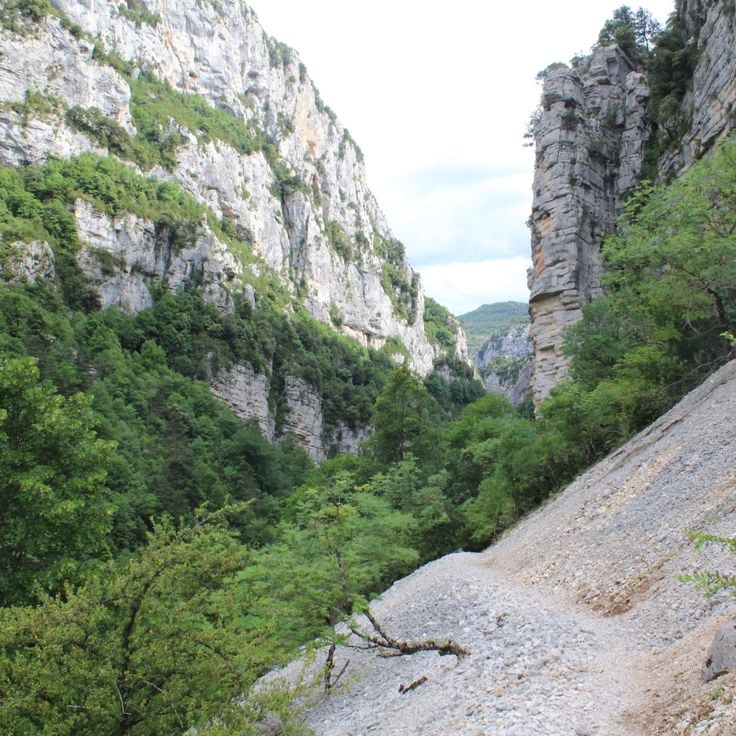
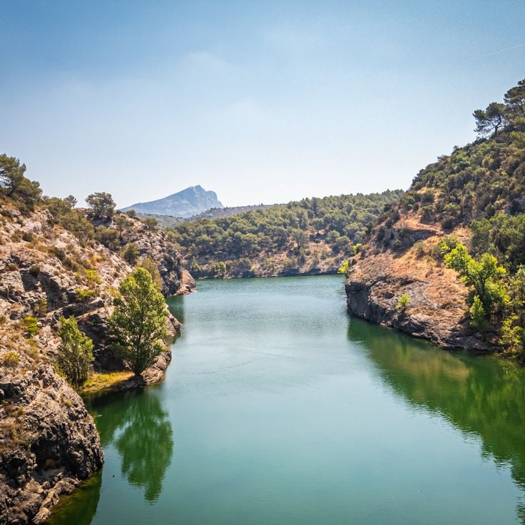
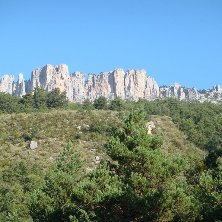
These gorges within the collection provide hikers with access to a canyon that cuts down to 700 meters in depth. The limestone walls form steep sides along which several marked paths run, totaling around 100 kilometers. The routes follow both the rim and lower sections closer to the riverbed, offering different perspectives on the geological formations. Walkers can observe the dimensions of the canyon from various elevations as the Verdon River flows through the gorge.
This road connects La Ciotat and Cassis over 15 kilometers (9 miles) along limestone cliffs that rise more than 350 meters (1,150 feet) above the Mediterranean Sea. The route runs between coastal sections and higher passages that offer views over the sea and the rocky formations. The cliffs show the geological makeup of the region, with white limestone standing in sharp contrast against the blue water. This connection between the two coastal towns is part of the hiking trails along the French Riviera that provide access to the Mediterranean coastal landscape and the rock formations.
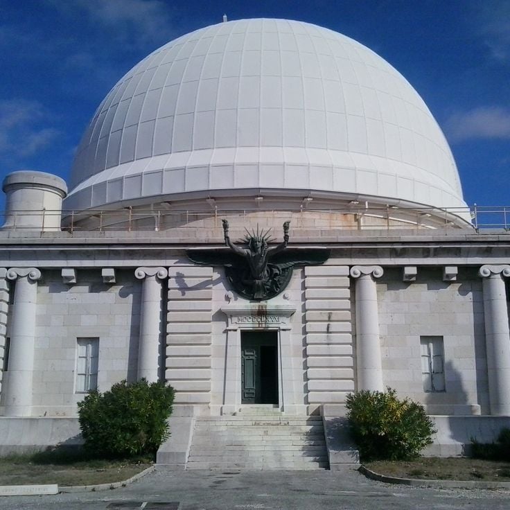
The Nice Observatory has occupied the summit of Mont Gros since its foundation in 1879. This scientific establishment preserves several 19th-century domes housing historical instruments, including the large equatorial telescope. The gardens surrounding the buildings present a botanical collection adapted to the Mediterranean climate. The site demonstrates the development of French astronomy through its architecture and technical equipment.
The Chemin de Nietzsche is a mountain path with a 400-meter elevation difference connecting the medieval village of Èze to sea level. Philosopher Friedrich Nietzsche regularly walked this route during his stays on the Côte d'Azur between 1883 and 1888. The trail passes through Mediterranean vegetation and provides views of the Mediterranean Sea.
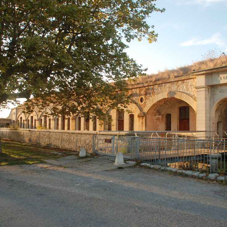
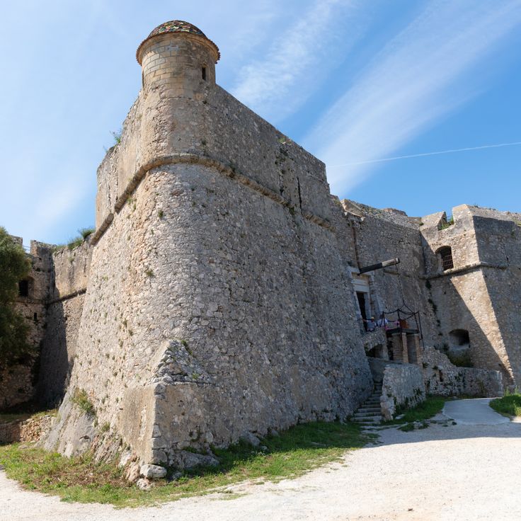
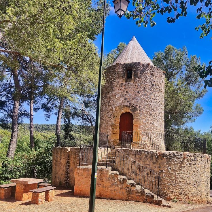
This military fort built in the 19th century stands at 696 meters altitude on the heights of Èze. The site features several hiking trails that provide access to different observation points over the Mediterranean coast. The historical fortifications showcase the military architecture of that era and offer an extended view over the sea and hinterland.
This area spreads over 57 hectares (140 acres) along the coast of Nice. It sits on the eastern side of the city, between the old port and the start of the hills. The park shows Mediterranean vegetation: pine trees, cypress, holm oaks and smaller shrubs cover the slopes. Eleven kilometers (7 miles) of marked trails run through the area, some following the coastline, others climbing inland. The paths differ in length and the slopes vary. Hikers find quiet routes here between the hills and the sea. From different points, you can look over the bay of Nice and toward the Alps in the background. The terrain forms part of the coastal trails between Nice and Monaco. These routes connect seaside sections with uphill segments into the inland areas.
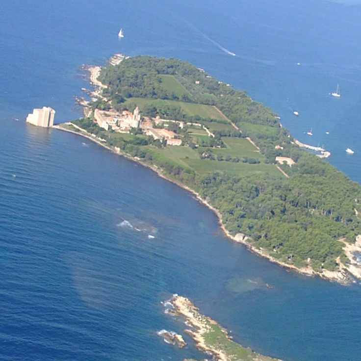
Saint-Honorat Island is home to Lérins Abbey, a Cistercian monastic community active since the 5th century. The monks cultivate vineyards that produce local wines and maintain several historical chapels scattered across the island. Marked trails allow visitors to walk around the coastline and through pine forests and olive groves, providing viewpoints over the Mediterranean Sea and the neighboring Sainte-Marguerite Island.
Pointe des Sans Culottes is a rocky promontory extending into the Mediterranean east of Nice. This natural headland is covered with typical Mediterranean vegetation and provides viewpoints over the Bay of Nice and the surrounding coastline. The site is accessible via the coastal path that runs along the shore between Nice and Villefranche-sur-Mer.
The Tanneron Massif extends across the Var hinterland and consists of wooded hills reaching approximately 600 meters in elevation. This region is known for its mimosa forests that bloom during winter and early spring. The massif offers several hiking trails that cross forest areas of cork oaks and chestnut trees. The routes provide access to observation points with views of the Mediterranean and the Southern Alps. The Tanneron territory also contains Provençal villages and cut flower production sites.
This state forest covers a wide area where trails wind through red porphyry rocks and Mediterranean plants. The paths in this forest connect the coast with inland areas and offer routes suitable for exploring the nature of the French Riviera. The rock formations in this forest show a reddish color typical of this region.
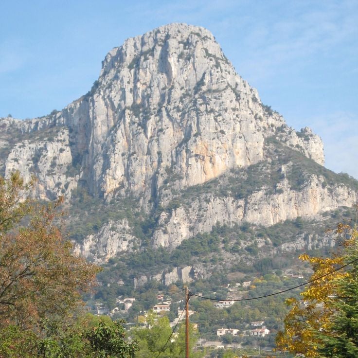
The Baou de Saint-Jeannet is an 800-meter (2,625-foot) limestone cliff in the Côte d'Azur hinterland, part of this hiking route between Nice and Monaco. Marked trails lead to the summit, while the vertical south face serves as a climbing area. From the top, the view extends over forested valleys, the rolling hills of the region, and the foothills of the Maritime Alps. The formation rises sharply above the village of Saint-Jeannet and acts as a natural landmark. The ascent follows partly rocky paths through Mediterranean vegetation. This cliff shows the geological character of the coastal region also visible along the route between Nice and Monaco.
This circular trail crosses the peninsula by the sea, between Monaco and Menton. The path mostly runs close to the coast and provides direct access to the water and to beaches set among rocks. In some sections, the route moves through dense pine vegetation that offers shade in summer. The tour takes about an hour and a half and is suitable for walking outside the hottest hours of the day. From several points, the Monaco coastline and the mountains opposite are visible. The path is paved and stays near sea level, without major ascents. It passes near the villa where Le Corbusier spent his final years and ends close to the spot where he swam in the sea in 1965.
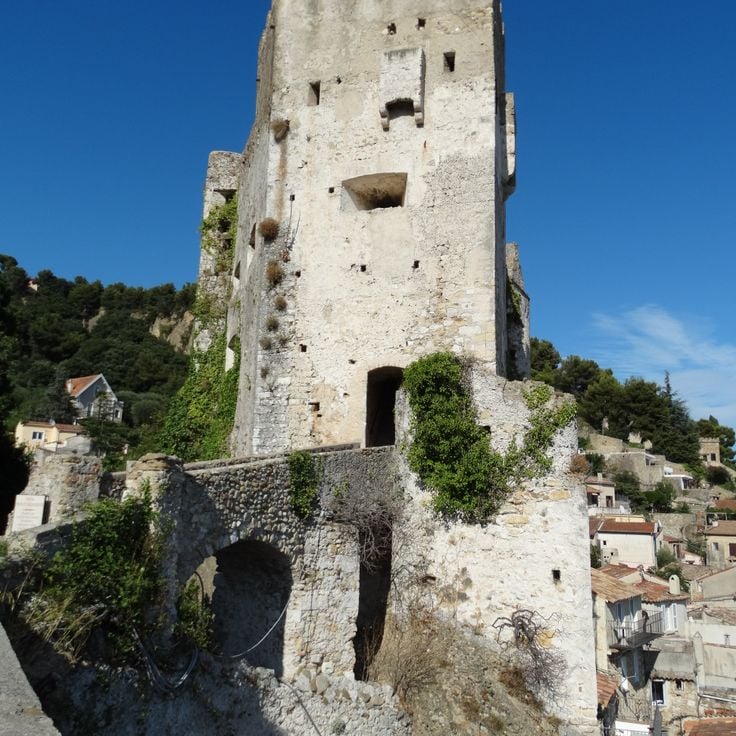
This medieval castle rises above Roquebrune-Cap-Martin and serves as a starting point for exploring the coastal paths between Nice and Monaco. Dating from the 10th century, Chateau de Roquebrune stands on a rocky outcrop overlooking the Mediterranean and the surrounding hills. Its stone walls and square keep reflect the medieval construction methods of the region. From the ramparts and terraces, the coastline stretches toward Monaco. The village clusters around the castle, with narrow lanes and staircases winding between old houses. The paths around the castle connect with the coastal trails to Cap d'Ail and the high routes of the French Riviera.
This promontory extends over the peninsula of Saint-Jean-Cap-Ferrat and forms its easternmost point. The coastal path around it passes through pine forests and follows the edge of the cliffs with views over the open sea and the opposite shore. On clear days, the Italian Alps appear in the distance. A chapel dating from the 11th century and a bronze statue erected in 1904 mark the outermost point of the headland. The path connects with the larger network of coastal trails between Nice and Monaco, providing access to quieter sections of the Riviera.
This coastal path loops around the peninsula of Saint-Jean-Cap-Ferrat and connects with the network of hiking trails along the French Riviera between Nice and Monaco. The route follows the shoreline and offers views over the Mediterranean, passing through Mediterranean vegetation and alongside villas from the 19th and early 20th centuries that characterize the architecture of the area.
This 16th-century fortress stands on a hill in Nice and offers hikers on the coastal paths of the French Riviera a place to explore. It was built to oversee the bay, and its thick walls show the military past of the region. The walk to Mont Alban leads through woodland and opens to wide views over the coast and the inland areas. You can visit the fortifications from the outside, and paths around it invite you to walk. From up here you see Nice, the shoreline, and the mountains beyond. The fortress is a stop on the hiking routes between Nice and Monaco, connecting history with views of the Mediterranean landscape.
The coastal path of Cap d'Antibes links the coves of this headland along a trail that runs between pine trees and rocks. This route along the Mediterranean coast between Nice and Monaco provides access to sections where the water meets the cliffs and passes through quiet zones with views over the open sea. The path follows the natural contour of the coastline and makes the geology and vegetation of the French Riviera accessible.
This 14th-century castle stands directly on the coast west of Cannes, combining medieval architecture with the artistic legacy of an American sculptor couple from the 1920s. The thick stone walls, towers, and courtyards were restored and now house sculptures, ceramics, and murals. The Château de la Napoule serves as a starting point for coastal hikes along the French Riviera, offering insight into the historical layering of the region between sea and hinterland.
This fort sits on Sainte-Marguerite Island and forms part of the historical sites along the French Riviera. While coastal trails between Nice and Monaco provide access to cliffs, viewpoints and Mediterranean vegetation, routes to the islands off the coast reveal another side of the region. Fort Royal dates from the 17th century and was built under Louis XIV. The structure served to defend the coastline and housed various prisoners over time, including the legendary Man in the Iron Mask. Today the stone walls, casemates and cannons remain visible. From the ramparts you look out over the Mediterranean and the opposite shore near Cannes. The island itself is covered with forests and reached by a short boat ride from the mainland.
This trail follows the course of the Verdon River through the gorges, providing direct access to the limestone formations and turquoise water of the canyon. The route connects the coastal landscape of the French Riviera to the inland areas, passing through tunnels, over stairs, and along narrow paths beside the river. Sentier Martel crosses the deepest section of the gorge, showing the geological makeup of the region up close. Hikers move between tall rock walls and pass places where the river flows through tight passages.
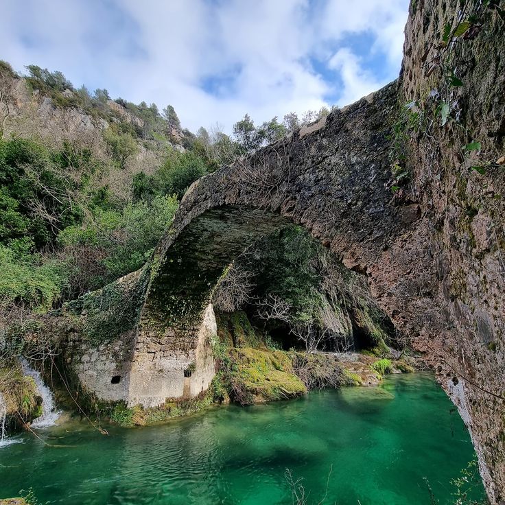
This stone bridge in Montauroux connects forest paths in the hinterland of the Côte d'Azur and provides access to the heights between the coast and the Verdon Gorges. The trail passes through a hilly landscape where old stone structures show how people used this region over time. The bridge itself is built from local stone and crosses a stream that winds through dense vegetation. From here you can explore routes that follow old trade paths and offer views of the surrounding hills and valleys. The area is part of a network of trails that open up the inland territory of the French Riviera.
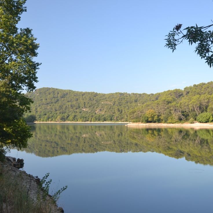
This artificial reservoir in the Var department sits surrounded by Mediterranean vegetation and rolling hills. The water reflects the surrounding forests and the Provençal sky. Walking paths follow the shoreline and provide views over the changing landscape between coastal region and inland areas. The Lac de Carcès shows the contrasts of Provence: green shores meet dry scrubland while birds circle above the still water. The surroundings connect the Mediterranean routes between coast and interior mountains.
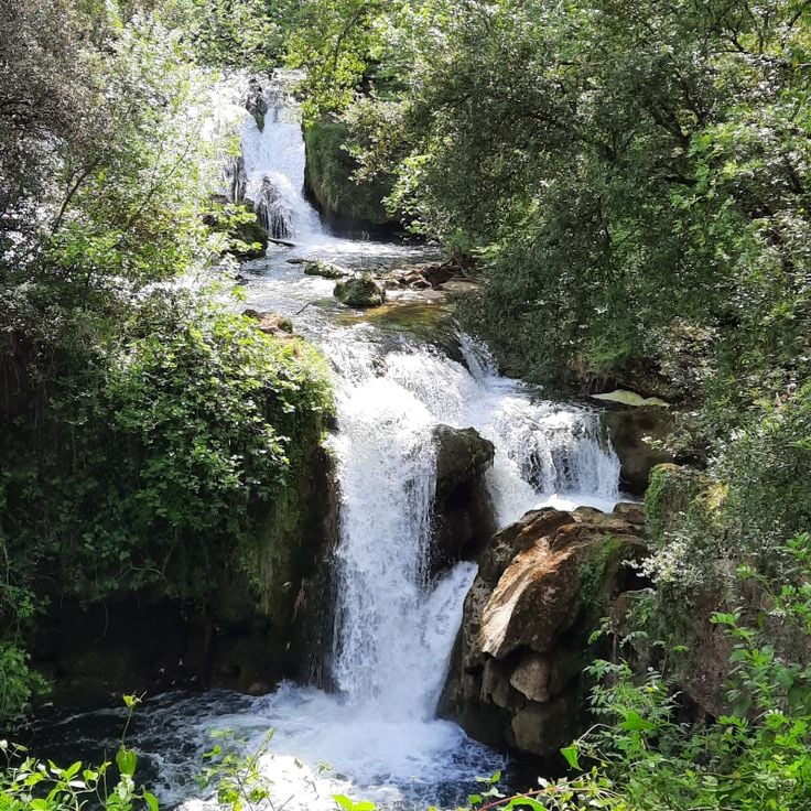
These two waterfalls lie near Carcès, in the hinterland of the Côte d'Azur. The Caramy River drops over rock formations into natural pools. Walking paths in the region pass through forests and connect the coast with inland areas. The site sits along routes linking the Mediterranean shore with the mountains further in. Hikers follow the watercourse through a wooded gorge. The falls are part of a network of trails that cross the area.
This French castle stands in Cassis, a town on the Mediterranean coast between Marseille and Toulon. The coastal trails of the French Riviera pass through different landscapes, from the cliffs at Cap d'Ail to the limestone formations between La Ciotat and Cassis. The château de Port-Miou sits in this area where rock faces meet the sea. The walking routes connect historic sites with natural viewpoints. Cassis borders steep rock walls and small inlets that characterize this section of coastline. This castle is among the structures found along the hiking routes between Nice and Monaco.
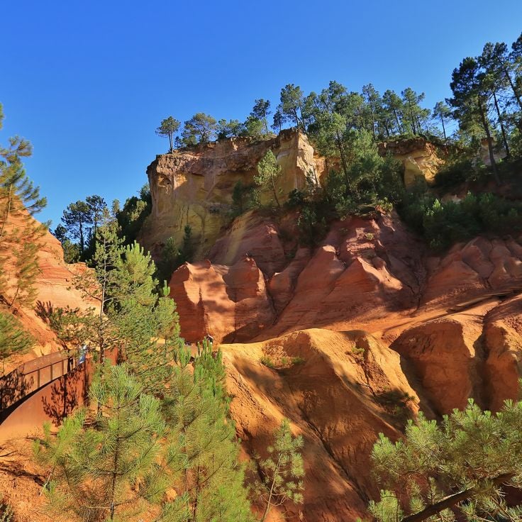
These ochre quarries near the edge of Roussillon reveal red-brown to ochre-colored rock faces shaped by iron-rich sandstone layers. Walking trails through the former mining areas shift from reddish to orange and yellow tones. The paths run between the quarry walls and provide access to the naturally eroded surfaces of this coastal region. The route links the geological history of the French Riviera with the inland mountain landscape between Nice and the Verdon.
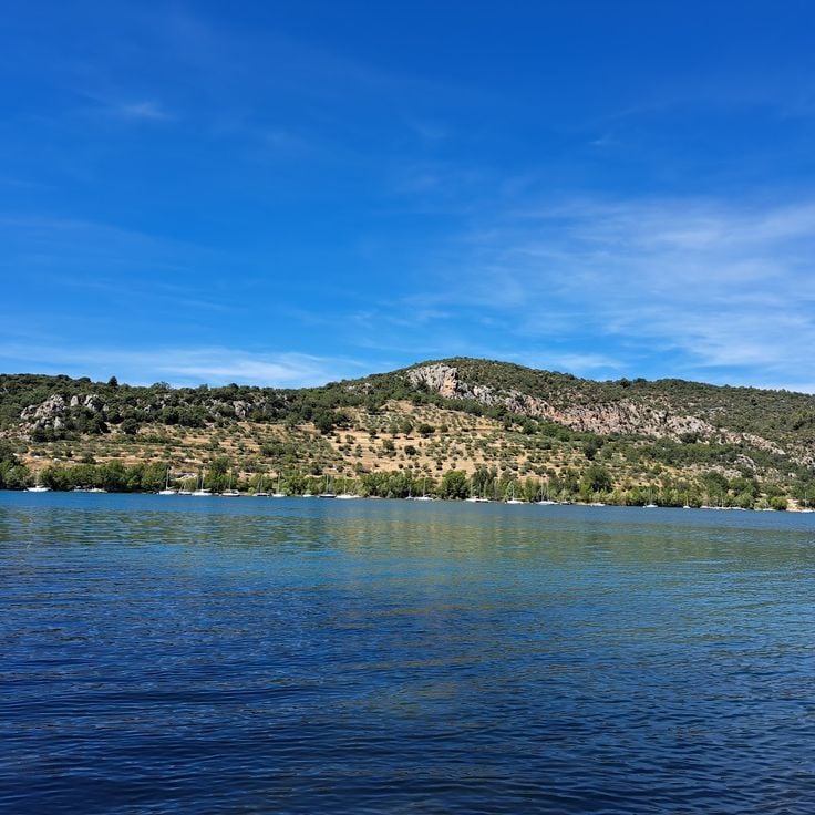
This peninsula extends into the turquoise Lac de Sainte-Croix, near the southern entrance to the Verdon Gorges. Trails pass through pine forests and along rocky shorelines surrounded by clear water. The area is well suited for walks in a quiet landscape, where boaters dock and hikers pause. From higher ground, the lake appears in its full extent, framed by the limestone cliffs of the surrounding terrain.
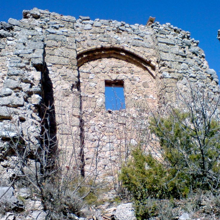
This chapel ruin stands in the Trévans Gorges and belongs to the historical traces found along routes between the coast and the inland areas of the French Riviera. The remains of Chapelle Saint-André d'Estoublon lie away from the more traveled paths and mark a place where religious traditions meet the rough landscape of the gorges.
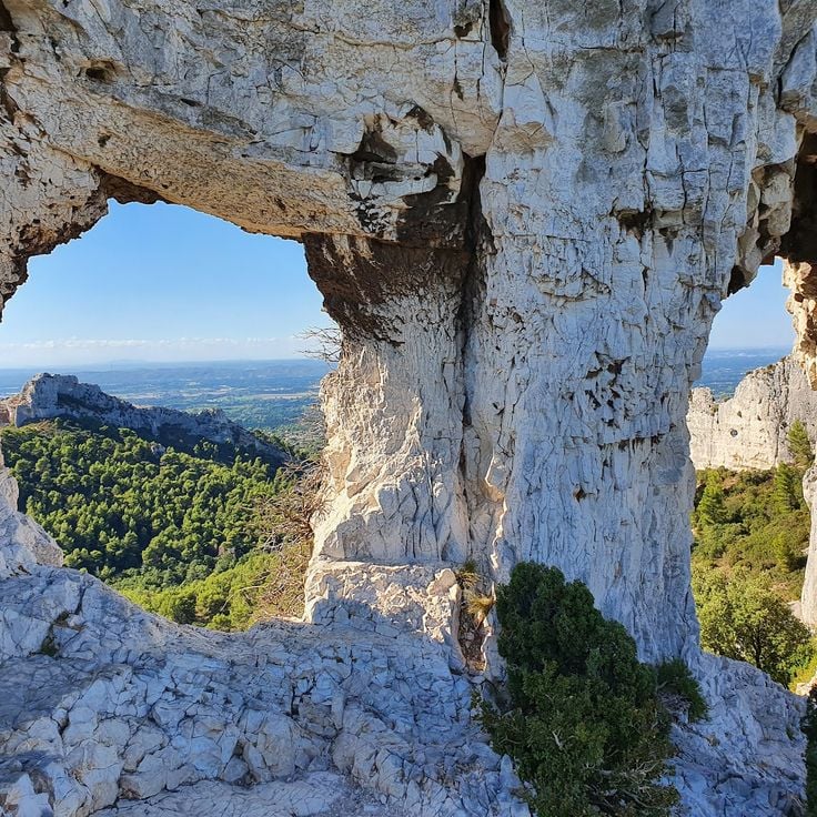
This rock formation along the coastal paths between Nice and Monaco takes its name from two natural openings in the limestone. The formation sits by the Mediterranean and appears different under varying light throughout the day. Hikers pass this point on routes that combine seaside sections with uphill segments, offering views over the water.
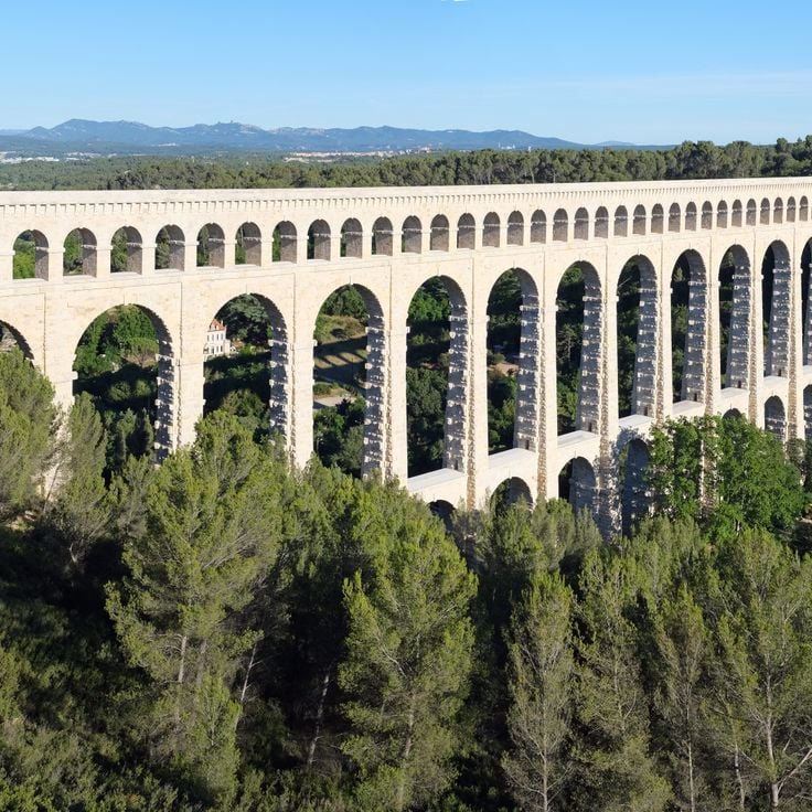
This stone aqueduct from the 19th century carries the Canal de Marseille over the valley of the Arc River. The structure rises through three tiers of arches to 83 meters (272 feet). The upper arches support the waterway, while the middle and lower levels consist of solid pillars arranged at regular intervals. Walking the surrounding paths reveals the scale of the construction against the hills of Provence. The bridge stands as evidence of the engineering methods of its era, connecting the coastal trails between Nice and Monaco with the historical heritage of the hinterland.
This Romanesque chapel in Tourves is among the historical landmarks found along the hiking routes between the coast and the hinterland of the French Riviera. Chapelle Saint-Probace stands on a small hill outside the village and dates from the 12th century. The simple stone building with its rectangular plan shows the typical features of Provençal Romanesque: small windows, thick walls, and a plain portal. Inside, the vaulting of rough stones is visible and the walls are bare. The surroundings are quiet, with olive groves and low oak trees on the hills. From here you can see across the plain toward the first mountains to the north. The chapel is used for a Mass once a year and otherwise remains closed. A short path from the village leads here, passing vineyards and dry-stone walls.
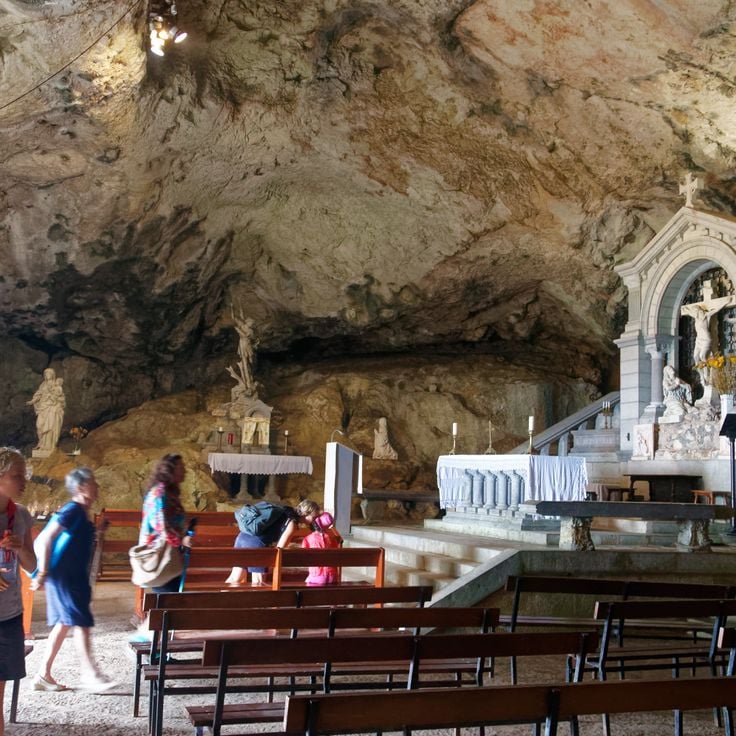
This Gothic church and mountain cave complex lies in the Sainte-Baume mountain range, about an hour inland from the coast. The basilica, built in the 13th century, stands in Saint-Maximin and is considered an important example of southern French Gothic architecture. The interior features high vaults, narrow windows, and a simple choir. The crypt houses old sarcophagi and relics from Roman times. A hiking trail leads from the town through forests and rocks to the Grotte de la Sainte-Baume, a cave at 3100 feet (946 meters) elevation. The climb takes about an hour and passes through beech forests that provide shade in summer. The cave itself is small, damp, and set in a rock face. Pilgrims have been coming here since the Middle Ages. A small chapel stands in front of the entrance. The connection between basilica and mountain cave shows the religious importance of these places to the region and adds insight into the hinterland to the coastal trails of the French Riviera.
This historic windmill in the village of Le Tholonet stands east of Aix-en-Provence at the foot of the Sainte-Victoire mountain. It belongs to the motifs Paul Cézanne painted several times when he worked in the area between 1885 and 1906. The building sits on a rise among pine forests and olive groves, surrounded by the Provençal landscape the painter often depicted. Visitors reach the mill through hiking trails that lead from the village into the hills. The area forms part of the routes that explore the nature and history of the French Riviera.
This artificial lake lies south of Aix-en-Provence in the Arc valley and was built between 1854 and 1859. The area offers a short loop of around 2.5 miles through pine forests and wooded hills. Lac Zola is part of the walking landscape between the coast near Nice and Monaco, where Mediterranean paths connect with routes further inland. From here, the northern foothills of the Sainte-Victoire massif are visible.
This lake sits within the Luberon Regional Natural Park, on a plateau near the Gorges de la Nesque. The area of Plan d'eau de Monieux consists of a man-made basin surrounded by rock walls and forested slopes. The spot serves as a starting point for hikes toward the gorges and the village of Monieux, perched on a rocky outcrop. The routes along the water connect to trails leading higher into the limestone formations. The lake reflects the colors of the seasons and shows the sparse landscape of the High Provence with oak and pine trees. From here, you can trace the structure of the plateau and the depth of the nearby gorges.
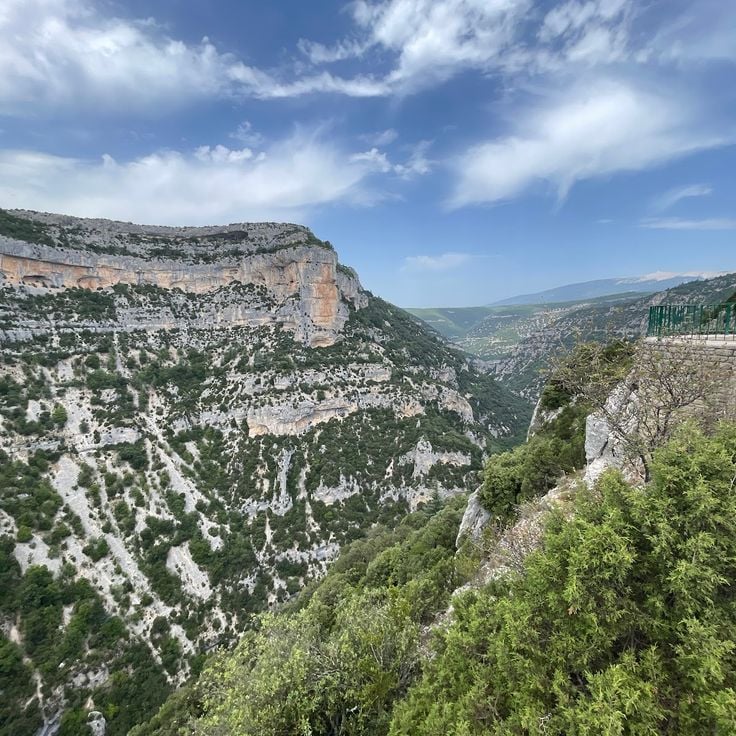
This canyon cuts 400 meters (1,300 feet) deep into the limestone of the Vaucluse plateau, connecting the coastal trails of the French Riviera with the mountain areas of Provence. The Route des Gorges de la Nesque follows the edge of the canyon for about 20 kilometers (12 miles) between Monieux and Villes-sur-Auzon. Several viewpoints along the route open onto the cliffs, the river bends, and the forests at the bottom of the gorge. The Nesque river carved this cut into the rock over time, and the walls show the layers of limestone.
This remote canyon in the hinterland of the French Riviera sits in a region marked by steep limestone walls and natural rock formations. La Combe de Vaumale runs through a narrow valley where hiking trails wind between the rock faces. The terrain rises through several hundred feet of elevation gain, connecting the proximity of the coast with the mountains of the Provençal backcountry. The paths through this canyon provide access to a landscape where Mediterranean and alpine vegetation meet, offering different views over the surrounding ridges and valleys.
This village in Vaucluse sits on a rocky outcrop above the plain, surrounded by wooded slopes and limestone formations. The narrow lanes climb steeply upward, while the remains of a medieval castle mark the highest point. From Le Beaucet, trails wind through oak forests and along dry valleys, showing the transitions between coastal paths and the Provençal interior that characterize these hiking routes.
This Benedictine abbey sits on a hill in the Vaucluse, surrounded by vineyards and lavender fields. The monks follow the Rule of Saint Benedict and celebrate the liturgy in Gregorian chant. The monastery was founded in the 20th century and combines traditional monastic life with manual work. The Romanesque architecture of the church blends into the Provençal landscape, while the interior conveys simplicity and silence. Visitors may attend the services or purchase products made by the monastery. This abbey offers insight into the contemplative life of a community living according to ancient order.
This dolmen stands away from the coastal routes of the French Riviera, recalling the earliest settlements in the La Londe-les-Maures region. The stone slabs that form this Neolithic burial site date from a time when hunter-gatherers began to bury their dead. The site sits in a wooded area, surrounded by Mediterranean vegetation, where silence and shade prevail.
Cadières de Brandis is a mountain in the Verdon area that rises above the surrounding terrain and offers hiking trails with views over the gorges and wooded valleys. This route connects the coastal paths of the French Riviera with the inland territory and adds to the diversity of landscapes between the Mediterranean and the limestone formations of the region. The ascent passes through Mediterranean vegetation, while the summit provides an overview of the geological structure of the Verdon area. This mountain is part of the routes that extend the coastal experience between Nice and Monaco into the natural spaces of the interior.
This lake sits at 7,060 feet (2,151 meters) above sea level in the Mercantour National Park, set within a high-altitude valley. Rocky slopes and sparse alpine meadows frame the water, which rests in a mineral landscape beneath open sky. The walk to reach it passes through mountain terrain with scattered vegetation and offers views across the surrounding uplands. Lac de Trécolpas serves as a stopping point for hikers on longer routes through the high mountain country of the French Alps and gives a sense of the geological character that shapes this upland region.
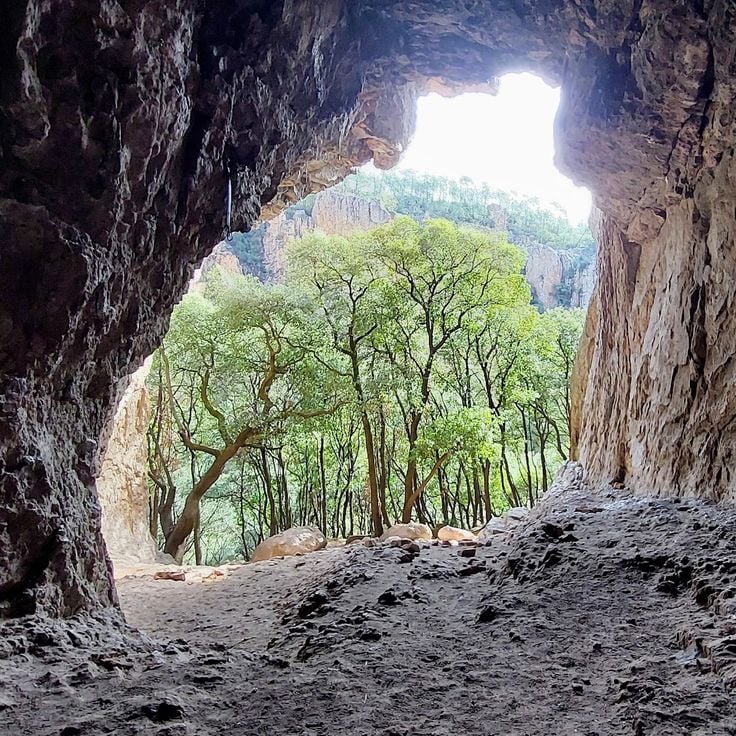
This cave in the Verdon valley sits among the steep limestone walls that frame the river. The Grotte de Mueron opens in the rock face above the water and can be reached by a narrow path that winds through the typical vegetation of the gorges. Inside, the space widens into a large chamber where light enters through the opening and illuminates the smooth surface of the walls. Bats inhabit the darker corners, and in summer the cave offers a cool refuge from the heat outside. The acoustics amplify every sound, and the rush of the Verdon river can be heard even from this height. Hikers often use this spot as a resting point before continuing along the canyon. The cave illustrates the geological history of the region and complements the collection of coastal and mountain paths between Nice and the Gorges du Verdon.
This trail sits in the hills above the coast and crosses wooded valleys as part of the collection of coastal paths between Nice and Monaco. The path climbs through pine forests and provides access to quieter sections away from the Mediterranean beaches. The route connects the inland nature with the historical and geological themes of the French Riviera, complementing the seaside walks with a look at the forested slopes of the region.
This waterfall sits in the backcountry of the French Riviera and forms part of the hiking routes that cross the forested valleys of the region. The water drops over several tiers between rocks and vegetation. The path leading to it follows a stream through a shaded forest, offering a quiet alternative to the coastal trails between Nice and Monaco. The surroundings remain cool even on warm days, and the route suits hikers looking to explore the wooded uplands of the Riviera.
This former customs path runs along the Mediterranean coast for 4 kilometers, connecting several beaches and coves between the port of Nice and Cap de Nice. The Sentier des Douaniers offers views over the turquoise waters and passes through sections of Mediterranean vegetation.
These gorges within the collection provide hikers with access to a canyon that cuts down to 700 meters in depth. The limestone walls form steep sides along which several marked paths run, totaling around 100 kilometers. The routes follow both the rim and lower sections closer to the riverbed, offering different perspectives on the geological formations. Walkers can observe the dimensions of the canyon from various elevations as the Verdon River flows through the gorge.
This road connects La Ciotat and Cassis over 15 kilometers (9 miles) along limestone cliffs that rise more than 350 meters (1,150 feet) above the Mediterranean Sea. The route runs between coastal sections and higher passages that offer views over the sea and the rocky formations. The cliffs show the geological makeup of the region, with white limestone standing in sharp contrast against the blue water. This connection between the two coastal towns is part of the hiking trails along the French Riviera that provide access to the Mediterranean coastal landscape and the rock formations.
The Nice Observatory has occupied the summit of Mont Gros since its foundation in 1879. This scientific establishment preserves several 19th-century domes housing historical instruments, including the large equatorial telescope. The gardens surrounding the buildings present a botanical collection adapted to the Mediterranean climate. The site demonstrates the development of French astronomy through its architecture and technical equipment.
The Chemin de Nietzsche is a mountain path with a 400-meter elevation difference connecting the medieval village of Èze to sea level. Philosopher Friedrich Nietzsche regularly walked this route during his stays on the Côte d'Azur between 1883 and 1888. The trail passes through Mediterranean vegetation and provides views of the Mediterranean Sea.
This military fort built in the 19th century stands at 696 meters altitude on the heights of Èze. The site features several hiking trails that provide access to different observation points over the Mediterranean coast. The historical fortifications showcase the military architecture of that era and offer an extended view over the sea and hinterland.
This area spreads over 57 hectares (140 acres) along the coast of Nice. It sits on the eastern side of the city, between the old port and the start of the hills. The park shows Mediterranean vegetation: pine trees, cypress, holm oaks and smaller shrubs cover the slopes. Eleven kilometers (7 miles) of marked trails run through the area, some following the coastline, others climbing inland. The paths differ in length and the slopes vary. Hikers find quiet routes here between the hills and the sea. From different points, you can look over the bay of Nice and toward the Alps in the background. The terrain forms part of the coastal trails between Nice and Monaco. These routes connect seaside sections with uphill segments into the inland areas.
Saint-Honorat Island is home to Lérins Abbey, a Cistercian monastic community active since the 5th century. The monks cultivate vineyards that produce local wines and maintain several historical chapels scattered across the island. Marked trails allow visitors to walk around the coastline and through pine forests and olive groves, providing viewpoints over the Mediterranean Sea and the neighboring Sainte-Marguerite Island.
Pointe des Sans Culottes is a rocky promontory extending into the Mediterranean east of Nice. This natural headland is covered with typical Mediterranean vegetation and provides viewpoints over the Bay of Nice and the surrounding coastline. The site is accessible via the coastal path that runs along the shore between Nice and Villefranche-sur-Mer.
The Tanneron Massif extends across the Var hinterland and consists of wooded hills reaching approximately 600 meters in elevation. This region is known for its mimosa forests that bloom during winter and early spring. The massif offers several hiking trails that cross forest areas of cork oaks and chestnut trees. The routes provide access to observation points with views of the Mediterranean and the Southern Alps. The Tanneron territory also contains Provençal villages and cut flower production sites.
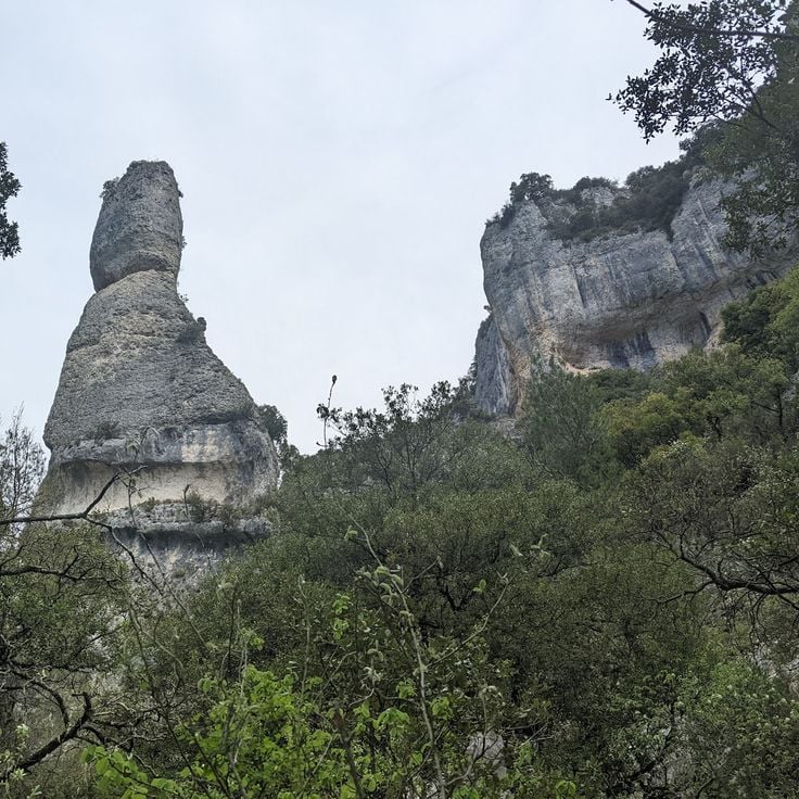
This state forest covers a wide area where trails wind through red porphyry rocks and Mediterranean plants. The paths in this forest connect the coast with inland areas and offer routes suitable for exploring the nature of the French Riviera. The rock formations in this forest show a reddish color typical of this region.
The Baou de Saint-Jeannet is an 800-meter (2,625-foot) limestone cliff in the Côte d'Azur hinterland, part of this hiking route between Nice and Monaco. Marked trails lead to the summit, while the vertical south face serves as a climbing area. From the top, the view extends over forested valleys, the rolling hills of the region, and the foothills of the Maritime Alps. The formation rises sharply above the village of Saint-Jeannet and acts as a natural landmark. The ascent follows partly rocky paths through Mediterranean vegetation. This cliff shows the geological character of the coastal region also visible along the route between Nice and Monaco.
This circular trail crosses the peninsula by the sea, between Monaco and Menton. The path mostly runs close to the coast and provides direct access to the water and to beaches set among rocks. In some sections, the route moves through dense pine vegetation that offers shade in summer. The tour takes about an hour and a half and is suitable for walking outside the hottest hours of the day. From several points, the Monaco coastline and the mountains opposite are visible. The path is paved and stays near sea level, without major ascents. It passes near the villa where Le Corbusier spent his final years and ends close to the spot where he swam in the sea in 1965.
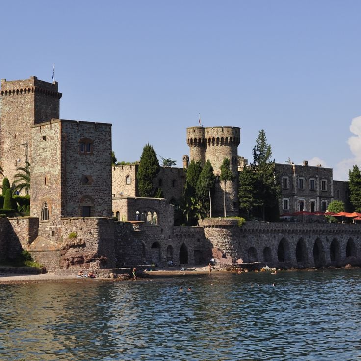
This medieval castle rises above Roquebrune-Cap-Martin and serves as a starting point for exploring the coastal paths between Nice and Monaco. Dating from the 10th century, Chateau de Roquebrune stands on a rocky outcrop overlooking the Mediterranean and the surrounding hills. Its stone walls and square keep reflect the medieval construction methods of the region. From the ramparts and terraces, the coastline stretches toward Monaco. The village clusters around the castle, with narrow lanes and staircases winding between old houses. The paths around the castle connect with the coastal trails to Cap d'Ail and the high routes of the French Riviera.
This promontory extends over the peninsula of Saint-Jean-Cap-Ferrat and forms its easternmost point. The coastal path around it passes through pine forests and follows the edge of the cliffs with views over the open sea and the opposite shore. On clear days, the Italian Alps appear in the distance. A chapel dating from the 11th century and a bronze statue erected in 1904 mark the outermost point of the headland. The path connects with the larger network of coastal trails between Nice and Monaco, providing access to quieter sections of the Riviera.
This coastal path loops around the peninsula of Saint-Jean-Cap-Ferrat and connects with the network of hiking trails along the French Riviera between Nice and Monaco. The route follows the shoreline and offers views over the Mediterranean, passing through Mediterranean vegetation and alongside villas from the 19th and early 20th centuries that characterize the architecture of the area.
This 16th-century fortress stands on a hill in Nice and offers hikers on the coastal paths of the French Riviera a place to explore. It was built to oversee the bay, and its thick walls show the military past of the region. The walk to Mont Alban leads through woodland and opens to wide views over the coast and the inland areas. You can visit the fortifications from the outside, and paths around it invite you to walk. From up here you see Nice, the shoreline, and the mountains beyond. The fortress is a stop on the hiking routes between Nice and Monaco, connecting history with views of the Mediterranean landscape.
The coastal path of Cap d'Antibes links the coves of this headland along a trail that runs between pine trees and rocks. This route along the Mediterranean coast between Nice and Monaco provides access to sections where the water meets the cliffs and passes through quiet zones with views over the open sea. The path follows the natural contour of the coastline and makes the geology and vegetation of the French Riviera accessible.
This 14th-century castle stands directly on the coast west of Cannes, combining medieval architecture with the artistic legacy of an American sculptor couple from the 1920s. The thick stone walls, towers, and courtyards were restored and now house sculptures, ceramics, and murals. The Château de la Napoule serves as a starting point for coastal hikes along the French Riviera, offering insight into the historical layering of the region between sea and hinterland.
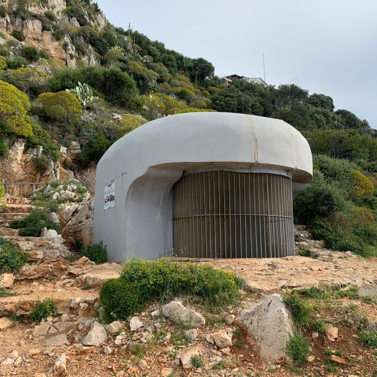
This fort sits on Sainte-Marguerite Island and forms part of the historical sites along the French Riviera. While coastal trails between Nice and Monaco provide access to cliffs, viewpoints and Mediterranean vegetation, routes to the islands off the coast reveal another side of the region. Fort Royal dates from the 17th century and was built under Louis XIV. The structure served to defend the coastline and housed various prisoners over time, including the legendary Man in the Iron Mask. Today the stone walls, casemates and cannons remain visible. From the ramparts you look out over the Mediterranean and the opposite shore near Cannes. The island itself is covered with forests and reached by a short boat ride from the mainland.
This trail follows the course of the Verdon River through the gorges, providing direct access to the limestone formations and turquoise water of the canyon. The route connects the coastal landscape of the French Riviera to the inland areas, passing through tunnels, over stairs, and along narrow paths beside the river. Sentier Martel crosses the deepest section of the gorge, showing the geological makeup of the region up close. Hikers move between tall rock walls and pass places where the river flows through tight passages.
This stone bridge in Montauroux connects forest paths in the hinterland of the Côte d'Azur and provides access to the heights between the coast and the Verdon Gorges. The trail passes through a hilly landscape where old stone structures show how people used this region over time. The bridge itself is built from local stone and crosses a stream that winds through dense vegetation. From here you can explore routes that follow old trade paths and offer views of the surrounding hills and valleys. The area is part of a network of trails that open up the inland territory of the French Riviera.
This artificial reservoir in the Var department sits surrounded by Mediterranean vegetation and rolling hills. The water reflects the surrounding forests and the Provençal sky. Walking paths follow the shoreline and provide views over the changing landscape between coastal region and inland areas. The Lac de Carcès shows the contrasts of Provence: green shores meet dry scrubland while birds circle above the still water. The surroundings connect the Mediterranean routes between coast and interior mountains.
These two waterfalls lie near Carcès, in the hinterland of the Côte d'Azur. The Caramy River drops over rock formations into natural pools. Walking paths in the region pass through forests and connect the coast with inland areas. The site sits along routes linking the Mediterranean shore with the mountains further in. Hikers follow the watercourse through a wooded gorge. The falls are part of a network of trails that cross the area.
This French castle stands in Cassis, a town on the Mediterranean coast between Marseille and Toulon. The coastal trails of the French Riviera pass through different landscapes, from the cliffs at Cap d'Ail to the limestone formations between La Ciotat and Cassis. The château de Port-Miou sits in this area where rock faces meet the sea. The walking routes connect historic sites with natural viewpoints. Cassis borders steep rock walls and small inlets that characterize this section of coastline. This castle is among the structures found along the hiking routes between Nice and Monaco.
These ochre quarries near the edge of Roussillon reveal red-brown to ochre-colored rock faces shaped by iron-rich sandstone layers. Walking trails through the former mining areas shift from reddish to orange and yellow tones. The paths run between the quarry walls and provide access to the naturally eroded surfaces of this coastal region. The route links the geological history of the French Riviera with the inland mountain landscape between Nice and the Verdon.
This peninsula extends into the turquoise Lac de Sainte-Croix, near the southern entrance to the Verdon Gorges. Trails pass through pine forests and along rocky shorelines surrounded by clear water. The area is well suited for walks in a quiet landscape, where boaters dock and hikers pause. From higher ground, the lake appears in its full extent, framed by the limestone cliffs of the surrounding terrain.
This chapel ruin stands in the Trévans Gorges and belongs to the historical traces found along routes between the coast and the inland areas of the French Riviera. The remains of Chapelle Saint-André d'Estoublon lie away from the more traveled paths and mark a place where religious traditions meet the rough landscape of the gorges.
This rock formation along the coastal paths between Nice and Monaco takes its name from two natural openings in the limestone. The formation sits by the Mediterranean and appears different under varying light throughout the day. Hikers pass this point on routes that combine seaside sections with uphill segments, offering views over the water.
This stone aqueduct from the 19th century carries the Canal de Marseille over the valley of the Arc River. The structure rises through three tiers of arches to 83 meters (272 feet). The upper arches support the waterway, while the middle and lower levels consist of solid pillars arranged at regular intervals. Walking the surrounding paths reveals the scale of the construction against the hills of Provence. The bridge stands as evidence of the engineering methods of its era, connecting the coastal trails between Nice and Monaco with the historical heritage of the hinterland.
This Romanesque chapel in Tourves is among the historical landmarks found along the hiking routes between the coast and the hinterland of the French Riviera. Chapelle Saint-Probace stands on a small hill outside the village and dates from the 12th century. The simple stone building with its rectangular plan shows the typical features of Provençal Romanesque: small windows, thick walls, and a plain portal. Inside, the vaulting of rough stones is visible and the walls are bare. The surroundings are quiet, with olive groves and low oak trees on the hills. From here you can see across the plain toward the first mountains to the north. The chapel is used for a Mass once a year and otherwise remains closed. A short path from the village leads here, passing vineyards and dry-stone walls.
This Gothic church and mountain cave complex lies in the Sainte-Baume mountain range, about an hour inland from the coast. The basilica, built in the 13th century, stands in Saint-Maximin and is considered an important example of southern French Gothic architecture. The interior features high vaults, narrow windows, and a simple choir. The crypt houses old sarcophagi and relics from Roman times. A hiking trail leads from the town through forests and rocks to the Grotte de la Sainte-Baume, a cave at 3100 feet (946 meters) elevation. The climb takes about an hour and passes through beech forests that provide shade in summer. The cave itself is small, damp, and set in a rock face. Pilgrims have been coming here since the Middle Ages. A small chapel stands in front of the entrance. The connection between basilica and mountain cave shows the religious importance of these places to the region and adds insight into the hinterland to the coastal trails of the French Riviera.
This historic windmill in the village of Le Tholonet stands east of Aix-en-Provence at the foot of the Sainte-Victoire mountain. It belongs to the motifs Paul Cézanne painted several times when he worked in the area between 1885 and 1906. The building sits on a rise among pine forests and olive groves, surrounded by the Provençal landscape the painter often depicted. Visitors reach the mill through hiking trails that lead from the village into the hills. The area forms part of the routes that explore the nature and history of the French Riviera.
This artificial lake lies south of Aix-en-Provence in the Arc valley and was built between 1854 and 1859. The area offers a short loop of around 2.5 miles through pine forests and wooded hills. Lac Zola is part of the walking landscape between the coast near Nice and Monaco, where Mediterranean paths connect with routes further inland. From here, the northern foothills of the Sainte-Victoire massif are visible.
This lake sits within the Luberon Regional Natural Park, on a plateau near the Gorges de la Nesque. The area of Plan d'eau de Monieux consists of a man-made basin surrounded by rock walls and forested slopes. The spot serves as a starting point for hikes toward the gorges and the village of Monieux, perched on a rocky outcrop. The routes along the water connect to trails leading higher into the limestone formations. The lake reflects the colors of the seasons and shows the sparse landscape of the High Provence with oak and pine trees. From here, you can trace the structure of the plateau and the depth of the nearby gorges.
This canyon cuts 400 meters (1,300 feet) deep into the limestone of the Vaucluse plateau, connecting the coastal trails of the French Riviera with the mountain areas of Provence. The Route des Gorges de la Nesque follows the edge of the canyon for about 20 kilometers (12 miles) between Monieux and Villes-sur-Auzon. Several viewpoints along the route open onto the cliffs, the river bends, and the forests at the bottom of the gorge. The Nesque river carved this cut into the rock over time, and the walls show the layers of limestone.
This remote canyon in the hinterland of the French Riviera sits in a region marked by steep limestone walls and natural rock formations. La Combe de Vaumale runs through a narrow valley where hiking trails wind between the rock faces. The terrain rises through several hundred feet of elevation gain, connecting the proximity of the coast with the mountains of the Provençal backcountry. The paths through this canyon provide access to a landscape where Mediterranean and alpine vegetation meet, offering different views over the surrounding ridges and valleys.
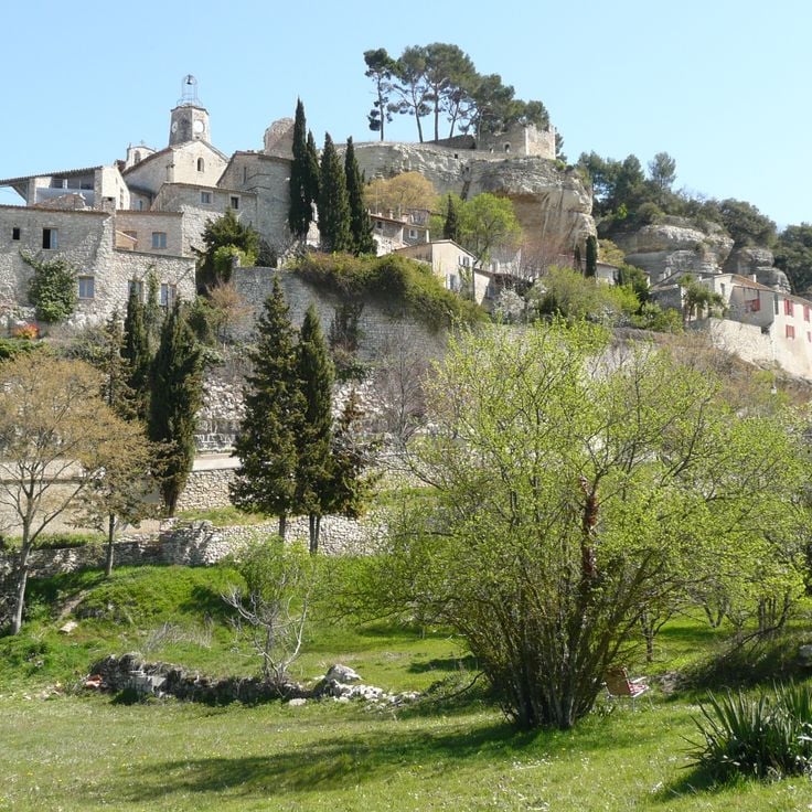
This village in Vaucluse sits on a rocky outcrop above the plain, surrounded by wooded slopes and limestone formations. The narrow lanes climb steeply upward, while the remains of a medieval castle mark the highest point. From Le Beaucet, trails wind through oak forests and along dry valleys, showing the transitions between coastal paths and the Provençal interior that characterize these hiking routes.
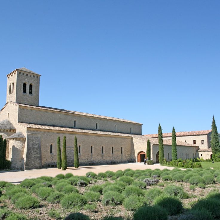
This Benedictine abbey sits on a hill in the Vaucluse, surrounded by vineyards and lavender fields. The monks follow the Rule of Saint Benedict and celebrate the liturgy in Gregorian chant. The monastery was founded in the 20th century and combines traditional monastic life with manual work. The Romanesque architecture of the church blends into the Provençal landscape, while the interior conveys simplicity and silence. Visitors may attend the services or purchase products made by the monastery. This abbey offers insight into the contemplative life of a community living according to ancient order.
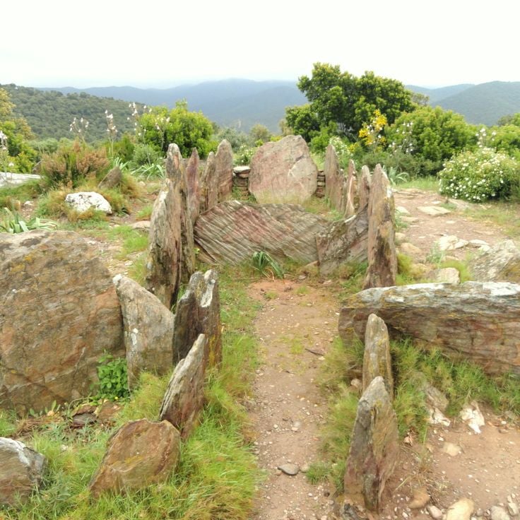
This dolmen stands away from the coastal routes of the French Riviera, recalling the earliest settlements in the La Londe-les-Maures region. The stone slabs that form this Neolithic burial site date from a time when hunter-gatherers began to bury their dead. The site sits in a wooded area, surrounded by Mediterranean vegetation, where silence and shade prevail.
Cadières de Brandis is a mountain in the Verdon area that rises above the surrounding terrain and offers hiking trails with views over the gorges and wooded valleys. This route connects the coastal paths of the French Riviera with the inland territory and adds to the diversity of landscapes between the Mediterranean and the limestone formations of the region. The ascent passes through Mediterranean vegetation, while the summit provides an overview of the geological structure of the Verdon area. This mountain is part of the routes that extend the coastal experience between Nice and Monaco into the natural spaces of the interior.
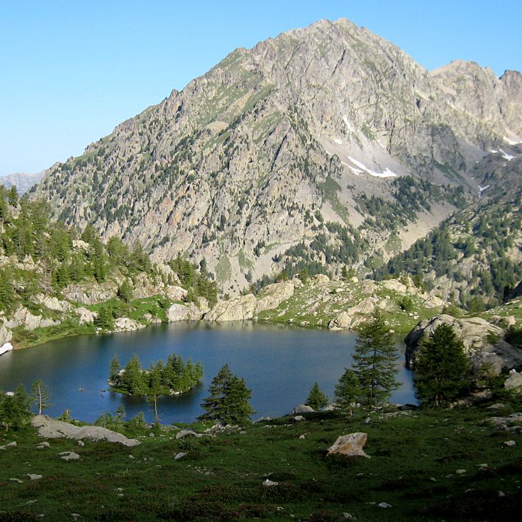
This lake sits at 7,060 feet (2,151 meters) above sea level in the Mercantour National Park, set within a high-altitude valley. Rocky slopes and sparse alpine meadows frame the water, which rests in a mineral landscape beneath open sky. The walk to reach it passes through mountain terrain with scattered vegetation and offers views across the surrounding uplands. Lac de Trécolpas serves as a stopping point for hikers on longer routes through the high mountain country of the French Alps and gives a sense of the geological character that shapes this upland region.
This cave in the Verdon valley sits among the steep limestone walls that frame the river. The Grotte de Mueron opens in the rock face above the water and can be reached by a narrow path that winds through the typical vegetation of the gorges. Inside, the space widens into a large chamber where light enters through the opening and illuminates the smooth surface of the walls. Bats inhabit the darker corners, and in summer the cave offers a cool refuge from the heat outside. The acoustics amplify every sound, and the rush of the Verdon river can be heard even from this height. Hikers often use this spot as a resting point before continuing along the canyon. The cave illustrates the geological history of the region and complements the collection of coastal and mountain paths between Nice and the Gorges du Verdon.
This trail sits in the hills above the coast and crosses wooded valleys as part of the collection of coastal paths between Nice and Monaco. The path climbs through pine forests and provides access to quieter sections away from the Mediterranean beaches. The route connects the inland nature with the historical and geological themes of the French Riviera, complementing the seaside walks with a look at the forested slopes of the region.
This waterfall sits in the backcountry of the French Riviera and forms part of the hiking routes that cross the forested valleys of the region. The water drops over several tiers between rocks and vegetation. The path leading to it follows a stream through a shaded forest, offering a quiet alternative to the coastal trails between Nice and Monaco. The surroundings remain cool even on warm days, and the route suits hikers looking to explore the wooded uplands of the Riviera.
This former customs path runs along the Mediterranean coast for 4 kilometers, connecting several beaches and coves between the port of Nice and Cap de Nice. The Sentier des Douaniers offers views over the turquoise waters and passes through sections of Mediterranean vegetation.
These gorges within the collection provide hikers with access to a canyon that cuts down to 700 meters in depth. The limestone walls form steep sides along which several marked paths run, totaling around 100 kilometers. The routes follow both the rim and lower sections closer to the riverbed, offering different perspectives on the geological formations. Walkers can observe the dimensions of the canyon from various elevations as the Verdon River flows through the gorge.
This road connects La Ciotat and Cassis over 15 kilometers (9 miles) along limestone cliffs that rise more than 350 meters (1,150 feet) above the Mediterranean Sea. The route runs between coastal sections and higher passages that offer views over the sea and the rocky formations. The cliffs show the geological makeup of the region, with white limestone standing in sharp contrast against the blue water. This connection between the two coastal towns is part of the hiking trails along the French Riviera that provide access to the Mediterranean coastal landscape and the rock formations.
The Nice Observatory has occupied the summit of Mont Gros since its foundation in 1879. This scientific establishment preserves several 19th-century domes housing historical instruments, including the large equatorial telescope. The gardens surrounding the buildings present a botanical collection adapted to the Mediterranean climate. The site demonstrates the development of French astronomy through its architecture and technical equipment.
The Chemin de Nietzsche is a mountain path with a 400-meter elevation difference connecting the medieval village of Èze to sea level. Philosopher Friedrich Nietzsche regularly walked this route during his stays on the Côte d'Azur between 1883 and 1888. The trail passes through Mediterranean vegetation and provides views of the Mediterranean Sea.
This military fort built in the 19th century stands at 696 meters altitude on the heights of Èze. The site features several hiking trails that provide access to different observation points over the Mediterranean coast. The historical fortifications showcase the military architecture of that era and offer an extended view over the sea and hinterland.
This area spreads over 57 hectares (140 acres) along the coast of Nice. It sits on the eastern side of the city, between the old port and the start of the hills. The park shows Mediterranean vegetation: pine trees, cypress, holm oaks and smaller shrubs cover the slopes. Eleven kilometers (7 miles) of marked trails run through the area, some following the coastline, others climbing inland. The paths differ in length and the slopes vary. Hikers find quiet routes here between the hills and the sea. From different points, you can look over the bay of Nice and toward the Alps in the background. The terrain forms part of the coastal trails between Nice and Monaco. These routes connect seaside sections with uphill segments into the inland areas.
Saint-Honorat Island is home to Lérins Abbey, a Cistercian monastic community active since the 5th century. The monks cultivate vineyards that produce local wines and maintain several historical chapels scattered across the island. Marked trails allow visitors to walk around the coastline and through pine forests and olive groves, providing viewpoints over the Mediterranean Sea and the neighboring Sainte-Marguerite Island.
Pointe des Sans Culottes is a rocky promontory extending into the Mediterranean east of Nice. This natural headland is covered with typical Mediterranean vegetation and provides viewpoints over the Bay of Nice and the surrounding coastline. The site is accessible via the coastal path that runs along the shore between Nice and Villefranche-sur-Mer.
The Tanneron Massif extends across the Var hinterland and consists of wooded hills reaching approximately 600 meters in elevation. This region is known for its mimosa forests that bloom during winter and early spring. The massif offers several hiking trails that cross forest areas of cork oaks and chestnut trees. The routes provide access to observation points with views of the Mediterranean and the Southern Alps. The Tanneron territory also contains Provençal villages and cut flower production sites.
This state forest covers a wide area where trails wind through red porphyry rocks and Mediterranean plants. The paths in this forest connect the coast with inland areas and offer routes suitable for exploring the nature of the French Riviera. The rock formations in this forest show a reddish color typical of this region.
The Baou de Saint-Jeannet is an 800-meter (2,625-foot) limestone cliff in the Côte d'Azur hinterland, part of this hiking route between Nice and Monaco. Marked trails lead to the summit, while the vertical south face serves as a climbing area. From the top, the view extends over forested valleys, the rolling hills of the region, and the foothills of the Maritime Alps. The formation rises sharply above the village of Saint-Jeannet and acts as a natural landmark. The ascent follows partly rocky paths through Mediterranean vegetation. This cliff shows the geological character of the coastal region also visible along the route between Nice and Monaco.
This circular trail crosses the peninsula by the sea, between Monaco and Menton. The path mostly runs close to the coast and provides direct access to the water and to beaches set among rocks. In some sections, the route moves through dense pine vegetation that offers shade in summer. The tour takes about an hour and a half and is suitable for walking outside the hottest hours of the day. From several points, the Monaco coastline and the mountains opposite are visible. The path is paved and stays near sea level, without major ascents. It passes near the villa where Le Corbusier spent his final years and ends close to the spot where he swam in the sea in 1965.
This medieval castle rises above Roquebrune-Cap-Martin and serves as a starting point for exploring the coastal paths between Nice and Monaco. Dating from the 10th century, Chateau de Roquebrune stands on a rocky outcrop overlooking the Mediterranean and the surrounding hills. Its stone walls and square keep reflect the medieval construction methods of the region. From the ramparts and terraces, the coastline stretches toward Monaco. The village clusters around the castle, with narrow lanes and staircases winding between old houses. The paths around the castle connect with the coastal trails to Cap d'Ail and the high routes of the French Riviera.
This promontory extends over the peninsula of Saint-Jean-Cap-Ferrat and forms its easternmost point. The coastal path around it passes through pine forests and follows the edge of the cliffs with views over the open sea and the opposite shore. On clear days, the Italian Alps appear in the distance. A chapel dating from the 11th century and a bronze statue erected in 1904 mark the outermost point of the headland. The path connects with the larger network of coastal trails between Nice and Monaco, providing access to quieter sections of the Riviera.
This coastal path loops around the peninsula of Saint-Jean-Cap-Ferrat and connects with the network of hiking trails along the French Riviera between Nice and Monaco. The route follows the shoreline and offers views over the Mediterranean, passing through Mediterranean vegetation and alongside villas from the 19th and early 20th centuries that characterize the architecture of the area.
This 16th-century fortress stands on a hill in Nice and offers hikers on the coastal paths of the French Riviera a place to explore. It was built to oversee the bay, and its thick walls show the military past of the region. The walk to Mont Alban leads through woodland and opens to wide views over the coast and the inland areas. You can visit the fortifications from the outside, and paths around it invite you to walk. From up here you see Nice, the shoreline, and the mountains beyond. The fortress is a stop on the hiking routes between Nice and Monaco, connecting history with views of the Mediterranean landscape.
The coastal path of Cap d'Antibes links the coves of this headland along a trail that runs between pine trees and rocks. This route along the Mediterranean coast between Nice and Monaco provides access to sections where the water meets the cliffs and passes through quiet zones with views over the open sea. The path follows the natural contour of the coastline and makes the geology and vegetation of the French Riviera accessible.
This 14th-century castle stands directly on the coast west of Cannes, combining medieval architecture with the artistic legacy of an American sculptor couple from the 1920s. The thick stone walls, towers, and courtyards were restored and now house sculptures, ceramics, and murals. The Château de la Napoule serves as a starting point for coastal hikes along the French Riviera, offering insight into the historical layering of the region between sea and hinterland.
This fort sits on Sainte-Marguerite Island and forms part of the historical sites along the French Riviera. While coastal trails between Nice and Monaco provide access to cliffs, viewpoints and Mediterranean vegetation, routes to the islands off the coast reveal another side of the region. Fort Royal dates from the 17th century and was built under Louis XIV. The structure served to defend the coastline and housed various prisoners over time, including the legendary Man in the Iron Mask. Today the stone walls, casemates and cannons remain visible. From the ramparts you look out over the Mediterranean and the opposite shore near Cannes. The island itself is covered with forests and reached by a short boat ride from the mainland.
This trail follows the course of the Verdon River through the gorges, providing direct access to the limestone formations and turquoise water of the canyon. The route connects the coastal landscape of the French Riviera to the inland areas, passing through tunnels, over stairs, and along narrow paths beside the river. Sentier Martel crosses the deepest section of the gorge, showing the geological makeup of the region up close. Hikers move between tall rock walls and pass places where the river flows through tight passages.
This stone bridge in Montauroux connects forest paths in the hinterland of the Côte d'Azur and provides access to the heights between the coast and the Verdon Gorges. The trail passes through a hilly landscape where old stone structures show how people used this region over time. The bridge itself is built from local stone and crosses a stream that winds through dense vegetation. From here you can explore routes that follow old trade paths and offer views of the surrounding hills and valleys. The area is part of a network of trails that open up the inland territory of the French Riviera.
This artificial reservoir in the Var department sits surrounded by Mediterranean vegetation and rolling hills. The water reflects the surrounding forests and the Provençal sky. Walking paths follow the shoreline and provide views over the changing landscape between coastal region and inland areas. The Lac de Carcès shows the contrasts of Provence: green shores meet dry scrubland while birds circle above the still water. The surroundings connect the Mediterranean routes between coast and interior mountains.
These two waterfalls lie near Carcès, in the hinterland of the Côte d'Azur. The Caramy River drops over rock formations into natural pools. Walking paths in the region pass through forests and connect the coast with inland areas. The site sits along routes linking the Mediterranean shore with the mountains further in. Hikers follow the watercourse through a wooded gorge. The falls are part of a network of trails that cross the area.
This French castle stands in Cassis, a town on the Mediterranean coast between Marseille and Toulon. The coastal trails of the French Riviera pass through different landscapes, from the cliffs at Cap d'Ail to the limestone formations between La Ciotat and Cassis. The château de Port-Miou sits in this area where rock faces meet the sea. The walking routes connect historic sites with natural viewpoints. Cassis borders steep rock walls and small inlets that characterize this section of coastline. This castle is among the structures found along the hiking routes between Nice and Monaco.
These ochre quarries near the edge of Roussillon reveal red-brown to ochre-colored rock faces shaped by iron-rich sandstone layers. Walking trails through the former mining areas shift from reddish to orange and yellow tones. The paths run between the quarry walls and provide access to the naturally eroded surfaces of this coastal region. The route links the geological history of the French Riviera with the inland mountain landscape between Nice and the Verdon.
This peninsula extends into the turquoise Lac de Sainte-Croix, near the southern entrance to the Verdon Gorges. Trails pass through pine forests and along rocky shorelines surrounded by clear water. The area is well suited for walks in a quiet landscape, where boaters dock and hikers pause. From higher ground, the lake appears in its full extent, framed by the limestone cliffs of the surrounding terrain.
This chapel ruin stands in the Trévans Gorges and belongs to the historical traces found along routes between the coast and the inland areas of the French Riviera. The remains of Chapelle Saint-André d'Estoublon lie away from the more traveled paths and mark a place where religious traditions meet the rough landscape of the gorges.
This rock formation along the coastal paths between Nice and Monaco takes its name from two natural openings in the limestone. The formation sits by the Mediterranean and appears different under varying light throughout the day. Hikers pass this point on routes that combine seaside sections with uphill segments, offering views over the water.
This stone aqueduct from the 19th century carries the Canal de Marseille over the valley of the Arc River. The structure rises through three tiers of arches to 83 meters (272 feet). The upper arches support the waterway, while the middle and lower levels consist of solid pillars arranged at regular intervals. Walking the surrounding paths reveals the scale of the construction against the hills of Provence. The bridge stands as evidence of the engineering methods of its era, connecting the coastal trails between Nice and Monaco with the historical heritage of the hinterland.
This Romanesque chapel in Tourves is among the historical landmarks found along the hiking routes between the coast and the hinterland of the French Riviera. Chapelle Saint-Probace stands on a small hill outside the village and dates from the 12th century. The simple stone building with its rectangular plan shows the typical features of Provençal Romanesque: small windows, thick walls, and a plain portal. Inside, the vaulting of rough stones is visible and the walls are bare. The surroundings are quiet, with olive groves and low oak trees on the hills. From here you can see across the plain toward the first mountains to the north. The chapel is used for a Mass once a year and otherwise remains closed. A short path from the village leads here, passing vineyards and dry-stone walls.
This Gothic church and mountain cave complex lies in the Sainte-Baume mountain range, about an hour inland from the coast. The basilica, built in the 13th century, stands in Saint-Maximin and is considered an important example of southern French Gothic architecture. The interior features high vaults, narrow windows, and a simple choir. The crypt houses old sarcophagi and relics from Roman times. A hiking trail leads from the town through forests and rocks to the Grotte de la Sainte-Baume, a cave at 3100 feet (946 meters) elevation. The climb takes about an hour and passes through beech forests that provide shade in summer. The cave itself is small, damp, and set in a rock face. Pilgrims have been coming here since the Middle Ages. A small chapel stands in front of the entrance. The connection between basilica and mountain cave shows the religious importance of these places to the region and adds insight into the hinterland to the coastal trails of the French Riviera.
This historic windmill in the village of Le Tholonet stands east of Aix-en-Provence at the foot of the Sainte-Victoire mountain. It belongs to the motifs Paul Cézanne painted several times when he worked in the area between 1885 and 1906. The building sits on a rise among pine forests and olive groves, surrounded by the Provençal landscape the painter often depicted. Visitors reach the mill through hiking trails that lead from the village into the hills. The area forms part of the routes that explore the nature and history of the French Riviera.
This artificial lake lies south of Aix-en-Provence in the Arc valley and was built between 1854 and 1859. The area offers a short loop of around 2.5 miles through pine forests and wooded hills. Lac Zola is part of the walking landscape between the coast near Nice and Monaco, where Mediterranean paths connect with routes further inland. From here, the northern foothills of the Sainte-Victoire massif are visible.
This lake sits within the Luberon Regional Natural Park, on a plateau near the Gorges de la Nesque. The area of Plan d'eau de Monieux consists of a man-made basin surrounded by rock walls and forested slopes. The spot serves as a starting point for hikes toward the gorges and the village of Monieux, perched on a rocky outcrop. The routes along the water connect to trails leading higher into the limestone formations. The lake reflects the colors of the seasons and shows the sparse landscape of the High Provence with oak and pine trees. From here, you can trace the structure of the plateau and the depth of the nearby gorges.
This canyon cuts 400 meters (1,300 feet) deep into the limestone of the Vaucluse plateau, connecting the coastal trails of the French Riviera with the mountain areas of Provence. The Route des Gorges de la Nesque follows the edge of the canyon for about 20 kilometers (12 miles) between Monieux and Villes-sur-Auzon. Several viewpoints along the route open onto the cliffs, the river bends, and the forests at the bottom of the gorge. The Nesque river carved this cut into the rock over time, and the walls show the layers of limestone.
This remote canyon in the hinterland of the French Riviera sits in a region marked by steep limestone walls and natural rock formations. La Combe de Vaumale runs through a narrow valley where hiking trails wind between the rock faces. The terrain rises through several hundred feet of elevation gain, connecting the proximity of the coast with the mountains of the Provençal backcountry. The paths through this canyon provide access to a landscape where Mediterranean and alpine vegetation meet, offering different views over the surrounding ridges and valleys.
This village in Vaucluse sits on a rocky outcrop above the plain, surrounded by wooded slopes and limestone formations. The narrow lanes climb steeply upward, while the remains of a medieval castle mark the highest point. From Le Beaucet, trails wind through oak forests and along dry valleys, showing the transitions between coastal paths and the Provençal interior that characterize these hiking routes.
This Benedictine abbey sits on a hill in the Vaucluse, surrounded by vineyards and lavender fields. The monks follow the Rule of Saint Benedict and celebrate the liturgy in Gregorian chant. The monastery was founded in the 20th century and combines traditional monastic life with manual work. The Romanesque architecture of the church blends into the Provençal landscape, while the interior conveys simplicity and silence. Visitors may attend the services or purchase products made by the monastery. This abbey offers insight into the contemplative life of a community living according to ancient order.
This dolmen stands away from the coastal routes of the French Riviera, recalling the earliest settlements in the La Londe-les-Maures region. The stone slabs that form this Neolithic burial site date from a time when hunter-gatherers began to bury their dead. The site sits in a wooded area, surrounded by Mediterranean vegetation, where silence and shade prevail.
Cadières de Brandis is a mountain in the Verdon area that rises above the surrounding terrain and offers hiking trails with views over the gorges and wooded valleys. This route connects the coastal paths of the French Riviera with the inland territory and adds to the diversity of landscapes between the Mediterranean and the limestone formations of the region. The ascent passes through Mediterranean vegetation, while the summit provides an overview of the geological structure of the Verdon area. This mountain is part of the routes that extend the coastal experience between Nice and Monaco into the natural spaces of the interior.
This lake sits at 7,060 feet (2,151 meters) above sea level in the Mercantour National Park, set within a high-altitude valley. Rocky slopes and sparse alpine meadows frame the water, which rests in a mineral landscape beneath open sky. The walk to reach it passes through mountain terrain with scattered vegetation and offers views across the surrounding uplands. Lac de Trécolpas serves as a stopping point for hikers on longer routes through the high mountain country of the French Alps and gives a sense of the geological character that shapes this upland region.
This cave in the Verdon valley sits among the steep limestone walls that frame the river. The Grotte de Mueron opens in the rock face above the water and can be reached by a narrow path that winds through the typical vegetation of the gorges. Inside, the space widens into a large chamber where light enters through the opening and illuminates the smooth surface of the walls. Bats inhabit the darker corners, and in summer the cave offers a cool refuge from the heat outside. The acoustics amplify every sound, and the rush of the Verdon river can be heard even from this height. Hikers often use this spot as a resting point before continuing along the canyon. The cave illustrates the geological history of the region and complements the collection of coastal and mountain paths between Nice and the Gorges du Verdon.
This trail sits in the hills above the coast and crosses wooded valleys as part of the collection of coastal paths between Nice and Monaco. The path climbs through pine forests and provides access to quieter sections away from the Mediterranean beaches. The route connects the inland nature with the historical and geological themes of the French Riviera, complementing the seaside walks with a look at the forested slopes of the region.
This waterfall sits in the backcountry of the French Riviera and forms part of the hiking routes that cross the forested valleys of the region. The water drops over several tiers between rocks and vegetation. The path leading to it follows a stream through a shaded forest, offering a quiet alternative to the coastal trails between Nice and Monaco. The surroundings remain cool even on warm days, and the route suits hikers looking to explore the wooded uplands of the Riviera.