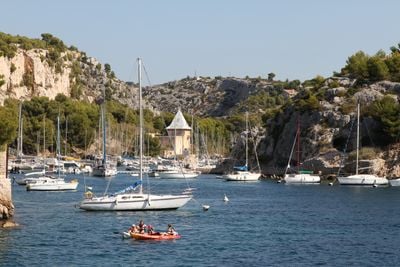
Château de Port-Miou, château français situé à Cassis
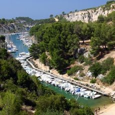
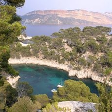
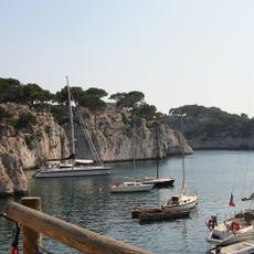
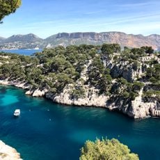
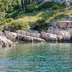
The Château de Port-Miou is a multi-story stone building with a tower standing on the north shore of the inlet that shares its name. It sits right by the water in a zone for boats and light equipment, surrounded by steep limestone cliffs shaped by former quarry work.
The building was first mentioned in official records in 1810 when purchased by the state, though its construction date and origin remain unclear. In the late 1800s the property became part of a Belgian industrial enterprise that extracted limestone here for soda production, an ingredient in Marseille soap.
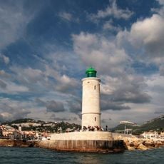
The name Port-Miou likely comes from the Provençal word for a small sheltered harbor where fishermen once moored their boats. The building now serves as a harbor master's office and information center where visitors learn about the national park and how the inlet is used today.
The site is about a 30-minute walk from Cassis or reachable by shuttle from the parking area. The upper floor and terrace open to the public during warmer months on certain days for exhibitions and events, so checking current access conditions beforehand is helpful.
The roof has beams shaped like animals that some believe came from an old ship, giving the building a maritime connection. Painter Joseph Garibaldi captured the property in an 1893 painting when quarry work was still ongoing and the inlet already showed signs of human activity.
Location: Cassis
Address: Unnamed Road, 13260 Cassis, France
GPS coordinates: 43.20860,5.51800
Latest update: December 5, 2025 12:43
Between Nice and Monaco, coastal trails provide the opportunity to explore the Mediterranean coastline through various routes. The Cap d'Ail Coastal Path, Nietzsche's Path in Èze with 400 meters of elevation gain, and the Mont Boron Park in Nice with its 11 kilometers of marked trails allow exploration of the region from different perspectives. These routes alternate between seaside sections and uphill segments, offering views over the coast and inland areas. The geological diversity of the region is evident in the limestone cliffs lining the Route des Crêtes between La Ciotat and Cassis, the rock formations of Cap d'Ail, and the red rocks of the Esterel Massif. Further inland, the Verdon Gorges feature a canyon 700 meters deep, while the Mercantour National Park houses the Sentier des Géants within its ancient forest. The historical heritage marks these routes: the Nice Observatory on Mont Gros dates from the 19th century, Fort La Revere overlooks the coast from 696 meters altitude, and Saint-Honorat Island preserves its active monastery. These trails serve as direct accesses to the nature and history of the French Riviera.
Calanque de Port-Miou
405 m
Plage de Port Pin
789 m
Port-Pin
790 m
Exsurgence de Port-Miou
553 m
Plage du Bestouan
1.2 km
Grotte des Trémies
998 m
Scenic viewpoint
1.1 km
Cassis Lighthouse
1.4 km
Scenic viewpoint
1.4 km
Scenic viewpoint
1.3 km
Propriété de la Fondation Camargo
1.4 km
Scenic viewpoint
527 m
Scenic viewpoint
144 m
Scenic viewpoint
365 m
Scenic viewpoint
1 km
View point
1.4 km
Scenic viewpoint
526 m
Scenic viewpoint
691 m
Scenic viewpoint
929 m
Trou Souffleur
791 m
Calanque de Port-Miou
479 m
Cliff jumping point
525 m
Calanque de Port-Pin
1 km
Port Mior Un lieu – la vie en or
367 m
Scenic viewpoint
152 m
Scenic viewpoint
193 m
Protée 1943
1.5 km
Memorial, commemorative plaque
1.5 kmReviews
Visited this place? Tap the stars to rate it and share your experience / photos with the community! Try now! You can cancel it anytime.
Discover hidden gems everywhere you go!
From secret cafés to breathtaking viewpoints, skip the crowded tourist spots and find places that match your style. Our app makes it easy with voice search, smart filtering, route optimization, and insider tips from travelers worldwide. Download now for the complete mobile experience.
A unique approach to discovering new places❞
— Le Figaro
All the places worth exploring❞
— France Info
A tailor-made excursion in just a few clicks❞
— 20 Minutes