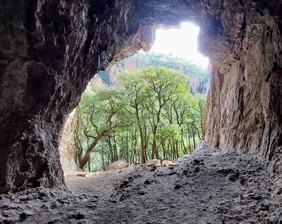
Enable Location

We need your location to show you interesting places around you

Discover nearby places

Find interesting locations and hidden gems around you

Precise directions

Get accurate directions and distances to places

Your location is never shared with other users. It's only used when you tap the location button.

Grotte de Mueron

Log in to your account

Start exploring — it's free

Trusted by 63,174 travelers worldwide

Continue with Google
Continue with Apple
or

We will send you a code to connect

By continuing, you accept our Terms and Conditions and our Privacy Policy

Check your inbox

We've sent a pincode in your inbox. Please enter the code below.

Grotte de Mueron
Discussion Reviews 1 Photos 1 Collections
100+ Popularity

Grotte de Mueron

Grotte de Muéron is a large natural cave with a wide entrance and a high ceiling carved into the red volcanic rhyolite rock of the Estérel massif near the Blavet River. The entrance sits at the base of a cliff face in the Gorges du Blavet, offering ample shelter from rain and wind.

Archaeological finds show that people lived in this cave about 12,000 years ago during the Magdalenian period, when it served as shelter during their migrations. The archaeologist Max Escalon de Fonton emphasized the importance of this site for understanding prehistoric settlements between Provence and Languedoc.

The name Muéron recalls the prehistoric inhabitants who sought shelter in this protected space. Today, climbers from across the Var département come here to scale the red volcanic walls that rise above the cave.

Access to the cave follows a hiking trail starting from the parking area below the RD 47, leading through a path of about two and a half miles that takes roughly two and a half hours. The route includes several fords across the Blavet and rocky sections with steep climbs and descents, so sturdy walking shoes are recommended.

Heavy use by climbers has prevented further archaeological excavation, leaving part of the cave's story still buried and unexplored. Visitors can observe natural hollows in the rock, called potholes, carved by the flowing water of the Blavet over thousands of years into the red rhyolite.

The community of curious travelers

AroundUs brings together thousands of curated places, local tips, and hidden gems, enriched daily by 60,000 contributors worldwide.

Start exploring
Address
Unnamed Road, 83600 Bagnols-en-Forêt, France
GPS coordinates
43.51741,6.65527
Latest update
December 5, 2025 11:25
Hiking along the French Riviera: Coastal paths between Nice and Monaco, from Cap d'Ail to the Gorges du Verdon

Between Nice and Monaco, coastal trails provide the opportunity to explore the Mediterranean coastline through various routes. The Cap d'Ail Coastal Path, Nietzsche's Path in Èze with 400 meters of elevation gain, and the Mont Boron Park in Nice with its 11 kilometers of marked trails allow...

Reviews
Share your experience

No review yet

Discussions
Start a discussion...

No discussion yet

« Grotte de Mueron » is provided by Around Us (aroundus.com). Images and texts are derived from Wikimedia project under a Creative Commons license. You are allowed to copy, distribute, and modify copies of this page, under the conditions set by the license, as long as this note is clearly visible.

Discover hidden gems everywhere you go!

From secret cafés to breathtaking viewpoints, skip the crowded tourist spots and find places that match your style. Our app makes it easy with voice search, smart filtering, route optimization, and insider tips from travelers worldwide. Download now for the complete mobile experience.

Around Us App Screenshot

A unique approach to discovering new places

Le Figaro

All the places worth exploring

France Info

A tailor-made excursion in just a few clicks

20 Minutes

Around Us
Travel Guide & Maps
Download

Send to your phone

QR Code
1

Open the camera app on your mobile.

2

Point at the QR code with your camera. A notification will appear.

3

Tap the notification to open the link.