The Atlantic Road
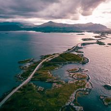
The Atlantic Road is a route in Norway about 8 kilometers long that crosses eight bridges connecting the island of Averøy to the mainland. It passes through an archipelago of small islands and skerries, with water and sea views from nearly every point along the journey.
Construction began in the early 1980s and the road opened in 1989, despite frequent severe storms that hindered the builders. This major infrastructure project created the first permanent link between isolated islands and the mainland, transforming access to the region.
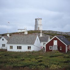
The road connects fishing communities that have depended on the sea for generations. Visitors today can observe how coastal traditions shape daily life, from local restaurants serving fresh seafood to small workshops keeping maritime crafts alive.
The road is free to drive and can be quite windy, especially during storms, so drivers should take their time and watch for gusts. Several parking areas and viewpoints are located along the route where you can stop to enjoy the scenery.
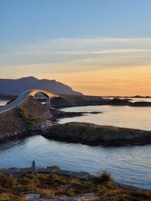
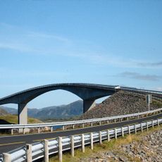
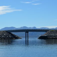
The most famous bridge on the route is Storseisundet, which curves elegantly and appears to float above the water. It has been featured in car commercials and films, becoming the image most people associate with this road.
Address: Fv64 120, 6494 Vevang, Norway
Website: https://nasjonaleturistveger.no/en/routes/atlanterhavsvegen
GPS coordinates: 63.01692,7.35569
Latest update: December 26, 2025 14:01
Norway is explored through areas that change from south to north. Beyond the Arctic Circle, Tromsø becomes a place to see the Northern Lights in winter, while Nordkapp marks the northern tip of continental Europe. Further south, the Lofoten islands rise from the sea with their fishing villages and...
Atlantic Ocean Road
65 m
Storseisundet Bridge
73 m
Kvitholmen Lighthouse
6.1 km
Geitøybrua
1.5 km
Gaustad kapell
4 kmSandblåst/Gaustadvågen
5.5 km
Minne over omkomne på havet
358 mStraumshaugbrua
4 kmHendvågen
5.3 kmGådalsfossen
6.9 kmSkildrihamran
7.8 kmLauvåsen
4.4 kmKronborghammaren
8.9 kmKnarrashaugmyra
5.9 kmTromskjera-Mannskjera
2.1 kmØrntollhammaren
6.6 kmLosstasjon på Teistklubben
7.3 kmBålhuset
4.1 kmLighthouse
3 kmVevang kystfort
4 kmStorheia
4.9 kmScenic viewpoint
557 mBjergje
8 kmScenic viewpoint
361 mScenic viewpoint
1.5 kmScenic viewpoint
2.8 kmScenic viewpoint
460 mGådalsfossen
6.9 kmVisited this place? Tap the stars to rate it and share your experience / photos with the community! Try now! You can cancel it anytime.
Discover hidden gems everywhere you go!
From secret cafés to breathtaking viewpoints, skip the crowded tourist spots and find places that match your style. Our app makes it easy with voice search, smart filtering, route optimization, and insider tips from travelers worldwide. Download now for the complete mobile experience.
A unique approach to discovering new places❞
— Le Figaro
All the places worth exploring❞
— France Info
A tailor-made excursion in just a few clicks❞
— 20 Minutes