Beachy Head Cliffs
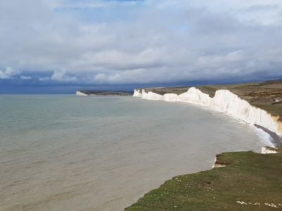
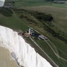
Beachy Head Cliffs are chalk headland in East Sussex that rises steeply about 160 meters above the sea. The white cliffs extend for several miles and offer expansive views across the English Channel and along the coast to distant points like Dungeness and the Isle of Wight.
The cliffs formed millions of years ago when the area was covered by sea and later exposed through land uplift. Sailors have used them as a navigation landmark for centuries, and in 1690 the Battle of Beachy Head took place in nearby waters.
The name "Beachy Head" comes from French words meaning beautiful headland and has been recorded since the 1200s. The white cliffs have become a familiar landmark in stories and art about the English coast and its seafaring heritage.
Wear sturdy shoes as paths can be uneven and the area is often windy and chilly even on sunny days. Most walking trails are well-maintained with some sections wheelchair accessible, and nearby cafes and a pub offer refreshments with views of the cliffs.
The site has become known as one of the world's most common places for suicides, prompting local groups to patrol the area and place support service numbers along the trails. The dramatic cliffs have also featured in films like Harry Potter and James Bond productions.
Address: Beachy Head Rd, Eastbourne BN20 0AB, UK
Opening Hours: Monday-Sunday 10:00-17:00
Phone: +441323423197
Website: http://nationaltrust.org.uk/birling-gap-and-the-seven-sisters
GPS coordinates: 50.74316,0.20105
Latest update: January 9, 2026 12:34
Sussex extends along the south coast of England, between London and the Channel. This area has different types of scenery: white chalk cliffs that rise above the sea, gentle hills of the South Downs, old forests, and valleys with quiet rivers. There are seaside towns such as Brighton and Eastbourne,...
Beachy Head Lighthouse
3 km
Belle Tout lighthouse
1.1 km
Seven Sisters Sheep Centre
1.1 kmBarn To The North Of Birling Manor
1.1 kmBirling Manor
1 kmMedieval farmstead and regular aggregate field system, 805m west of Crapham Barn
2.3 km
Camp near Belle Tout lighthouse, Birling Gap
649 mBowl barrow on Pashley Hill
4.1 kmBardolf's Hall, Birling Manor
948 mBowl barrow west of Paradise Plantation
4.5 kmBowl barrow 500m SSE of Cornish Farm
1.3 kmTwo bowl barrows south of Pashley
3.8 kmCross dyke on Pashley Hill
4.1 km
Hodeslea
5.2 kmSummer-House To South-East Of Birling Manor
1 kmMain Block And Chapel Of All Saints Hospital
5 kmShepherd's Hut To The North East Of New Barn, Birling Farm, East Dean
2 kmBowl barrow 500m north-east of Cornish Farm
1.7 kmBowl barrow and adjacent double bowl barrow E of Pashley
4.4 kmBowl barrow 150m south of Well Combe
4.3 kmBowl barrow west of Well Combe
4 kmField system on Bullock Down
2.9 kmGazebo In The Back Garden Of No 1
4.9 kmOutbuildings And Gate-Pier To South-West Of Birling Manor
960 mThree Barns To North West Of Birling Manor
1 kmCow Gap
4.2 kmScenic viewpoint
57 mScenic viewpoint
3.2 kmVisited this place? Tap the stars to rate it and share your experience / photos with the community! Try now! You can cancel it anytime.
Discover hidden gems everywhere you go!
From secret cafés to breathtaking viewpoints, skip the crowded tourist spots and find places that match your style. Our app makes it easy with voice search, smart filtering, route optimization, and insider tips from travelers worldwide. Download now for the complete mobile experience.
A unique approach to discovering new places❞
— Le Figaro
All the places worth exploring❞
— France Info
A tailor-made excursion in just a few clicks❞
— 20 Minutes