Enable Location

We need your location to show you interesting places around you

Discover nearby places

Find interesting locations and hidden gems around you

Precise directions

Get accurate directions and distances to places

Your location is never shared with other users. It's only used when you tap the location button.

Vilarinho da Furna

Log in to your account

Start exploring — it's free

Trusted by 62,474 travelers worldwide

Continue with Google
Continue with Apple
or

We will send you a code to connect

By continuing, you accept our Terms and Conditions and our Privacy Policy

Check your inbox

We've sent a pincode in your inbox. Please enter the code below.

Vilarinho da Furna

Vilarinho da Furna

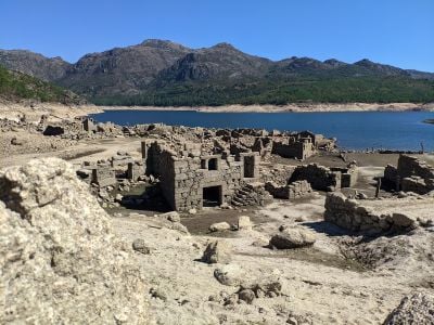
Vilarinho da Furna was a small mountain village in northern Portugal that now lies submerged beneath a reservoir. The settlement consisted of stone dwellings built on two levels, with livestock and storage on the lower floor and family living spaces above.

The village likely originated around the time of the Roman Geira road construction, which connected Braga to Astorga. In the 1970s, the construction of a dam flooded the area and forced all inhabitants to leave their homes.

This village was built on shared labor and mutual support, with decisions made collectively at regular community meetings. Traditional gatherings and horn music played important roles in maintaining the bonds between inhabitants.

When water levels drop in summer, ruins of the old village become visible at the water's edge. Wear sturdy shoes and bring water and sun protection, as reaching the site requires hiking over rough terrain.

An ethnographic museum preserves the village's history with original objects, photographs, and tools from the daily lives of former inhabitants. Each August, descendants and former residents gather for a reunion to honor their shared heritage.

The community of curious travelers

AroundUs brings together thousands of curated places, local tips, and hidden gems, enriched daily by 60,000 contributors worldwide.

Start exploring
Location
Address
4840 Campo do Gerês, Portugal
GPS coordinates
41.78049,-8.19683
Latest update
January 21, 2026 10:37
Northern Portugal: sights, Atlantic coast and Douro valley

Northern Portugal includes towns full of history, valleys shaped by vineyards, and mountains reaching to the Spanish border. Porto leads the region with its old center that slopes down towards the Douro River, iron bridges, baroque churches, and shopping streets lined with hundred-year-old...

« Vilarinho da Furna » is provided by Around Us (aroundus.com). Images and texts are derived from Wikimedia project under a Creative Commons license. You are allowed to copy, distribute, and modify copies of this page, under the conditions set by the license, as long as this note is clearly visible.

Discover hidden gems everywhere you go!

From secret cafés to breathtaking viewpoints, skip the crowded tourist spots and find places that match your style. Our app makes it easy with voice search, smart filtering, route optimization, and insider tips from travelers worldwide. Download now for the complete mobile experience.

Around Us App Screenshot

A unique approach to discovering new places

Le Figaro

All the places worth exploring

France Info

A tailor-made excursion in just a few clicks

20 Minutes

Around Us
Travel Guide & Maps
Download

Send to your phone

QR Code
1

Open the camera app on your mobile.

2

Point at the QR code with your camera. A notification will appear.

3

Tap the notification to open the link.