Enable Location

We need your location to show you interesting places around you

Discover nearby places

Find interesting locations and hidden gems around you

Precise directions

Get accurate directions and distances to places

Your location is never shared with other users. It's only used when you tap the location button.

Zillertaler Höhenstraße

Log in to your account

Save your favorite places
Create custom travel routes
Rate and review places
Access the full interactive map
Continue with Google
Continue with Apple
Continue with email
By continuing, you accept our Terms and Conditions and our Privacy Policy
Create an account

Zillertaler Höhenstraße

Add to collection
Map
Suggest a change
Share

Zillertaler Höhenstraße

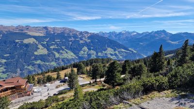
The Zillertaler Höhenstraße is a well-maintained mountain road in the Zillertal region of Austria that climbs to approximately 1815 meters elevation. It connects five different starting points and offers wide views of peaks, valleys, and open alpine pastures along the route.

Built in the 1960s to help mountain farmers manage pastures and control mountain streams, the road gradually became a popular tourist destination. Over time it transformed from a practical access route into a scenic drive that allows visitors to experience alpine landscapes with minimal effort.

The road was originally created to serve mountain farmers managing high pastures, a purpose still visible in the landscape today. Visitors can stop at mountain lodges along the route where traditional regional food reflects the local way of life in the Alps.

The road is accessible to various vehicle types including cars, motorcycles, and small buses up to about 33 feet (10 meters) long, with different tolls for each. Visitors should note that seasonal conditions affect access, and snow or poor weather may temporarily close sections of the route.

The road was designed from the start to serve a dual purpose: managing pastures and controlling mountain streams, not just providing scenic access. This practical foundation gives the landscape a working character that visitors often overlook when enjoying the views.

Address: Zillertaler Höhenstraße, 6274, Austria

Opening Hours: Monday-Saturday 09:00-17:00; Sunday 00:00-00:00

Website: http://zillertaler-hoehenstrasse.com

GPS coordinates: 47.25438,11.83647

Latest update: January 27, 2026 14:18

Photos
Tyrol Austria: must-visit places, mountain villages and natural sites

The Austrian Tyrol combines mountain landscapes, historic towns, and valleys where mountain life has gone on for hundreds of years. Innsbruck, the regional capital, has a old center with colorful buildings and archways. Valleys like Zillertal and Ötztal go deep into the Alps. They have villages...

Reviews

Visited this place? Tap the stars to rate it and share your experience / photos with the community! Try now! You can cancel it anytime.

« Zillertaler Höhenstraße » is provided by Around Us (aroundus.com). Images and texts are derived from Wikimedia project under a Creative Commons license. You are allowed to copy, distribute, and modify copies of this page, under the conditions set by the license, as long as this note is clearly visible.

Discover hidden gems everywhere you go!

From secret cafés to breathtaking viewpoints, skip the crowded tourist spots and find places that match your style. Our app makes it easy with voice search, smart filtering, route optimization, and insider tips from travelers worldwide. Download now for the complete mobile experience.

Around Us App Screenshot

A unique approach to discovering new places

Le Figaro

All the places worth exploring

France Info

A tailor-made excursion in just a few clicks

20 Minutes