Chest opened
+${chestReward.xp} XP
Explorer
NOUVEAU ×${chestReward.collectible.quantity}
tapez pour fermer

See the monuments around you in AR Open chests in the app

Around Us is built for your phone — point your camera at the streets and discover the monuments and places around you in augmented reality. Around Us is built for your phone — chests unlock when you walk, explore and capture nearby places.

•

Enable Location

We need your location to show you interesting places around you

Discover nearby places

Find interesting locations and hidden gems around you

Precise directions

Get accurate directions and distances to places

Your location is never shared with other users. It's only used when you tap the location button.

Pramenáč

Log in to your account

Start exploring — it's free

Trusted by 94,004 travelers worldwide

Continue with Google
Continue with Apple
or

We will send you a code to connect

By continuing, you accept our Terms and Conditions and our Privacy Policy

Check your inbox

We've sent a pincode in your inbox. Please enter the code below.

Pramenáč, Mountain summit in Košťany, Czech Republic

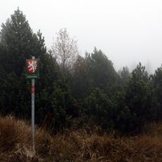
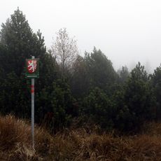
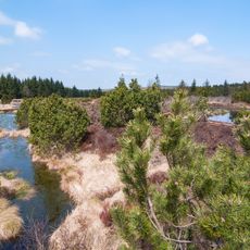
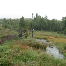
Bornhauberg, called Pramenáč in Czech, is the highest point of the Cínovec Highlands at 910 metres. Its broad, flat summit ridge holds remnants of a levelled surface with peat bogs, while the steeper southeast slope carries scattered scree and scree flows. Spruce forest covers the mountain, mixed with a little birch and pine.

Pramenáč lies in the Cínovec Highlands, the highest point of that range at 910 m. Its summit area keeps remnants of a levelled surface with peat bogs, while the steeper southeastern slope carries scattered scree and scree flows. The mountain is forested with spruce, with a little birch and pine.

The Czech name Pramenáč and the German Bornhauberg both appear on maps and in records, a pairing typical of the Krušné hory borderland. The summit lies in the cadastre of Košťany, though the village of Mikulov v Krušných horách sits 2 km to the southwest. The moorland on the northeast shoulder is marked on older maps as "Die See".

No marked trail leads to the summit; from the European long-distance path E3 at the Vitiška lodge, a forest road reaches the top in about 20 minutes. In winter a cross-country ski trail network runs over the forest roads and across the summit itself.

On the northeastern shoulder of Bornhauberg lies a high moor complex, marked on older maps as "Die See", which reaches as far as the Georgenfelder Hochmoor on German territory. In winter a cross-country ski trail network runs over the forest paths and across the summit itself.

The community of curious travelers

AroundUs brings together thousands of curated places, local tips, and hidden gems, enriched daily by 94,004 contributors worldwide.

Start exploring
Location
GPS coordinates
50.69920,13.73197
Latest update
October 24, 2026 10:20
Around this place
Georgenfelder Hochmoor
Germany

Georgenfelder Hochmoor

2.2 mi
Bouřňák
Czech Republic

Bouřňák

1.4 mi
Rašeliniště U jezera - Cínovecké rašeliniště
Czech Republic

Rašeliniště U jezera - Cínovecké rašeliniště

2 mi
Mikulovský tunel
Czech Republic

Mikulovský tunel

0.6 mi
Buky na Bouřňáku
Czech Republic

Buky na Bouřňáku

1.5 mi
Novoměstský tunel
Czech Republic

Novoměstský tunel

1.2 mi
Štola Lehnschafter
Czech Republic

Štola Lehnschafter

0.7 mi
Church of Saint Nicholas in Mikulov
Czech Republic

Church of Saint Nicholas in Mikulov

0.9 mi
Římskokatolická farnost Mikulov
Czech Republic

Římskokatolická farnost Mikulov

0.9 mi
Mikulov-Nové Město
Czech Republic

Mikulov-Nové Město

1.3 mi
Cínovecká hornatina
Czech Republic

Cínovecká hornatina

1.8 mi
Socha svatého Josefa v parku na náměstí v Mikulově
Czech Republic

Socha svatého Josefa v parku na náměstí v Mikulově

0.9 mi
Hřbitov
Czech Republic

Hřbitov

1 mi
Železniční viadukt u Mikulova v Krušných horách
Czech Republic

Železniční viadukt u Mikulova v Krušných horách

0.9 mi
Usedlost čp. 147
Czech Republic

Usedlost čp. 147

0.9 mi
Moldava 113
Czech Republic

Moldava 113

2.4 mi
Rašeliniště U jezera - Cínovecké rašeliniště
Czech Republic

Rašeliniště U jezera - Cínovecké rašeliniště

1.1 mi
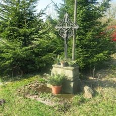
Dřevěný kříž v Košťanech na kopci Pramenáč
Czech Republic

Dřevěný kříž v Košťanech na kopci Pramenáč

80 ft
Kříž u silnice na dolním konci Mikulova
Czech Republic

Kříž u silnice na dolním konci Mikulova

1.1 mi
Tříkrálová štola
Czech Republic

Tříkrálová štola

1.1 mi
Kříž u rozcestí k golfišti v Cínovci
Czech Republic

Kříž u rozcestí k golfišti v Cínovci

2.4 mi
Kříž u rozcestí v centru Nového Města
Czech Republic

Kříž u rozcestí v centru Nového Města

1.6 mi
Kříž u autobusové zastávky Nové Město
Czech Republic

Kříž u autobusové zastávky Nové Město

1.7 mi
Pomník padlým v 1.světové válce na zdi kostela v Mikulově
Czech Republic

Pomník padlým v 1.světové válce na zdi kostela v Mikulově

0.9 mi
Kříž u kostela v Mikulově
Czech Republic

Kříž u kostela v Mikulově

0.9 mi
Kříž u chaty Mikulka v Mikulově
Czech Republic

Kříž u chaty Mikulka v Mikulově

0.9 mi
Kříž v ulici K Nádraží v Mikulově
Czech Republic

Kříž v ulici K Nádraží v Mikulově

0.7 mi
Georgenfelder Hochmoor
Germany

Georgenfelder Hochmoor

2.2 mi
Show the full map
Reviews
Share your experience

No review yet

Discussions
Start a discussion...

No discussion yet

« Pramenáč - Mountain summit in Košťany, Czech Republic » is provided by Around Us (aroundus.com). Images and texts are derived from Wikimedia project under a Creative Commons license. You are allowed to copy, distribute, and modify copies of this page, under the conditions set by the license, as long as this note is clearly visible.

Discover hidden gems everywhere you go!

From secret cafés to breathtaking viewpoints, skip the crowded tourist spots and find places that match your style. Our app makes it easy with voice search, smart filtering, route optimization, and insider tips from travelers worldwide. Download now for the complete mobile experience.

Around Us App Screenshot
❝

A unique approach to discovering new places❞

— Le Figaro

❝

All the places worth exploring❞

— France Info

❝

A tailor-made excursion in just a few clicks❞

— 20 Minutes

Around Us
Travel Guide & Maps
Download

Send to your phone

QR Code
1

Open the camera app on your mobile.

2

Point at the QR code with your camera. A notification will appear.

3

Tap the notification to open the link.