Enable Location

We need your location to show you interesting places around you

Discover nearby places

Find interesting locations and hidden gems around you

Precise directions

Get accurate directions and distances to places

Your location is never shared with other users. It's only used when you tap the location button.

Pastviny Reservoir

Log in to your account

Start exploring — it's free

Trusted by 62,369 travelers worldwide

Continue with Google
Continue with Apple
or

We will send you a code to connect

By continuing, you accept our Terms and Conditions and our Privacy Policy

Check your inbox

We've sent a pincode in your inbox. Please enter the code below.

Pastviny Reservoir

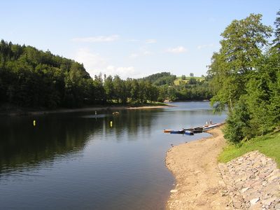
Pastviny Reservoir, reservoir in Pastviny, Czech Republic

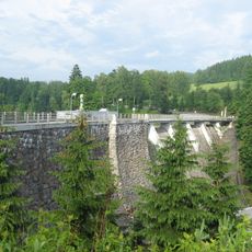
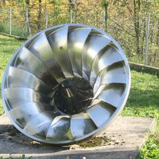
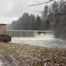
Pastviny Reservoir is a dam on the Divoká Orlice river in the Orlické mountains, stretching about 7 kilometers with a water surface covering around 110 hectares. The dam stands approximately 43 meters high and nearly 200 meters long, housing a hydroelectric power plant that generates electricity for the local area.

The reservoir was built between 1933 and 1938 to serve electricity generation and water management purposes. The hydroelectric plant was the largest of its kind in Czechoslovakia when completed and initially operated as a pump station before switching to run-of-river mode from the 1960s onward.

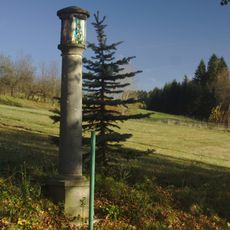
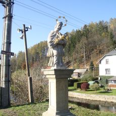
The area features walking and cycling paths with access to the shore for various activities. During summer months, swimming, water skiing, and fishing are popular, while winter brings skiing and cross-country skiing trails in the nearby village of Pastviny.

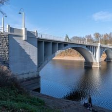
This dam is the last stone gravity dam of its kind in Czech Republic, showcasing remarkable engineering from the 1930s. A distinctive feature is the concrete arch bridge with two large arches that carries the road between Žamberk and Králíky across the water.

The community of curious travelers

AroundUs brings together thousands of curated places, local tips, and hidden gems, enriched daily by 60,000 contributors worldwide.

Start exploring
Location
Location
Inception
1933
GPS coordinates
50.08801,16.56059
Latest update
February 9, 2026 08:24
Around this place
Vejdova lípa
Czech Republic

Vejdova lípa

901 m
Bridge over Pastviny Reservoir
Czech Republic

Bridge over Pastviny Reservoir

638 m
Church of Holy Trinity
Czech Republic

Church of Holy Trinity

2.7 km
Klášterecký klen
Czech Republic

Klášterecký klen

2.7 km
Bouchalovy lípy
Czech Republic

Bouchalovy lípy

1.2 km
Maria column in Klášterec nad Orlicí
Czech Republic

Maria column in Klášterec nad Orlicí

2.7 km
Column shrine
Czech Republic

Column shrine

2.9 km
Socha Ježíše na hřbitově v Klášterci nad Orlicí
Czech Republic

Socha Ježíše na hřbitově v Klášterci nad Orlicí

2.6 km
Hloh obecný
Czech Republic

Hloh obecný

1.7 km
Památník obětem první světové války v Klášterci nad Orlicí
Czech Republic

Památník obětem první světové války v Klášterci nad Orlicí

2.9 km
Boží muka v Klášterci nad Orlicí v místní části Lhotka
Czech Republic

Boží muka v Klášterci nad Orlicí v místní části Lhotka

1.7 km
Kamenný kříž, Kalvárie
Czech Republic

Kamenný kříž, Kalvárie

756 m
Dům čp. 4
Czech Republic

Dům čp. 4

2.7 km
Pastviny Dam
Czech Republic

Pastviny Dam

1.4 km
Socha svatého Jana Nepomuckého v Nekoři
Czech Republic

Socha svatého Jana Nepomuckého v Nekoři

3 km
Turbína u vodní elektrárny Pastviny
Czech Republic

Turbína u vodní elektrárny Pastviny

1.5 km
Chapel in Studené
Czech Republic

Chapel in Studené

3 km
Boží muka na okraji Pastvin
Czech Republic

Boží muka na okraji Pastvin

1.5 km
Cemetery
Czech Republic

Cemetery

2.7 km
Pomník padlým ve Vlčkovicích
Czech Republic

Pomník padlým ve Vlčkovicích

2.8 km
Smírčí kříž ve Vlčkovicích
Czech Republic

Smírčí kříž ve Vlčkovicích

3 km
Kaplička v Pastvinách u silnice
Czech Republic

Kaplička v Pastvinách u silnice

768 m
Kaple svatého Dominika v Pastvinách v místní části zvané Vitanov
Czech Republic

Kaple svatého Dominika v Pastvinách v místní části zvané Vitanov

1.5 km
Kříž v Líšnici jihovýchodní okraj obce
Czech Republic

Kříž v Líšnici jihovýchodní okraj obce

2.9 km
Kaple sv. Josefa
Czech Republic

Kaple sv. Josefa

747 m
Kaple Panny Marie Růžencové v Pastvinách
Czech Republic

Kaple Panny Marie Růžencové v Pastvinách

132 m
Vodní nádrž Pastviny II
Czech Republic

Vodní nádrž Pastviny II

2 km
Křížek v Klášterci nad Orlicí
Czech Republic

Křížek v Klášterci nad Orlicí

2.3 km
Show the full map
« Pastviny Reservoir - reservoir in Pastviny, Czech Republic » is provided by Around Us (aroundus.com). Images and texts are derived from Wikimedia project under a Creative Commons license. You are allowed to copy, distribute, and modify copies of this page, under the conditions set by the license, as long as this note is clearly visible.

Discover hidden gems everywhere you go!

From secret cafés to breathtaking viewpoints, skip the crowded tourist spots and find places that match your style. Our app makes it easy with voice search, smart filtering, route optimization, and insider tips from travelers worldwide. Download now for the complete mobile experience.

Around Us App Screenshot

A unique approach to discovering new places

Le Figaro

All the places worth exploring

France Info

A tailor-made excursion in just a few clicks

20 Minutes

Around Us
Travel Guide & Maps
Download

Send to your phone

QR Code
1

Open the camera app on your mobile.

2

Point at the QR code with your camera. A notification will appear.

3

Tap the notification to open the link.