Enable Location

We need your location to show you interesting places around you

Discover nearby places

Find interesting locations and hidden gems around you

Precise directions

Get accurate directions and distances to places

Your location is never shared with other users. It's only used when you tap the location button.

Vraní skála

Log in to your account

Start exploring — it's free

Trusted by 63,188 travelers worldwide

Continue with Google
Continue with Apple
or

We will send you a code to connect

By continuing, you accept our Terms and Conditions and our Privacy Policy

Check your inbox

We've sent a pincode in your inbox. Please enter the code below.

Discussion Reviews 1 Photos
2.6k Popularity

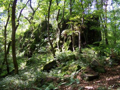
Vraní skála, Protected natural monument in Svatá, Czech Republic

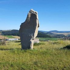
Vraní skála is a protected rock formation comprising four silicite blocks rising above 20 meters within a protected area spanning roughly 20 hectares. The stones offer panoramic views of the surrounding landscape from their height and create a distinctive landmark in the region.

The Czech Tourist Club secured protection for the site in 1948 to preserve this rare silicite formation. This early conservation effort reflects a long commitment to safeguarding the area for public benefit.

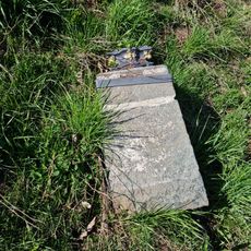
The site draws climbers who appreciate the established routes with equipment still visible, though climbing has been officially prohibited since 2003. The formations hold meaning for those interested in the rock climbing heritage of the region.

You can reach the site by driving to Svatá village and then following a marked hiking trail for about 1.7 kilometers. Comfortable walking shoes are recommended for this route, and visitors should note that climbing activities are not permitted.

The area is home to more than 50 spider species, including rare bark crab spiders and steppe crab spiders in their natural habitat. This rich diversity makes it a significant location for observing spider populations and their ecosystems.

The community of curious travelers

AroundUs brings together thousands of curated places, local tips, and hidden gems, enriched daily by 60,000 contributors worldwide.

Start exploring
Location
Inception
November 5, 1948
Elevation above the sea
536 m
GPS coordinates
49.92770,13.94110
Latest update
December 12, 2025 17:48
Around this place
Vila Hermína
Czech Republic

Vila Hermína

2.6 km
Stroupínský potok
Czech Republic

Stroupínský potok

3.2 km
Church of the Nativity of the Virgin Mary
Czech Republic

Church of the Nativity of the Virgin Mary

3.1 km
Town hall in Zdice
Czech Republic

Town hall in Zdice

3.1 km
Socha u pomníku padlým u obecního úřadu ve Svaté
Czech Republic

Socha u pomníku padlým u obecního úřadu ve Svaté

1.9 km
Zemědělský dvůr čp. 28
Czech Republic

Zemědělský dvůr čp. 28

3 km
World War I memorial in Zdice
Czech Republic

World War I memorial in Zdice

3.1 km
Kříž na hlavní křižovatce ve Svaté
Czech Republic

Kříž na hlavní křižovatce ve Svaté

1.8 km
Památník obětí politických procesů na hřbitově ve Zdicích
Czech Republic

Památník obětí politických procesů na hřbitově ve Zdicích

2.9 km
Kaplička na hřbitově ve Zdicích
Czech Republic

Kaplička na hřbitově ve Zdicích

2.9 km
Dub letní
Czech Republic

Dub letní

2.3 km
World Wars memorial in Svatá
Czech Republic

World Wars memorial in Svatá

1.9 km
Kříž na návsi v Černíně
Czech Republic

Kříž na návsi v Černíně

2.4 km
Kříž u silnice z Hředlí do Zdic
Czech Republic

Kříž u silnice z Hředlí do Zdic

3.1 km
World War II memorial in Zdice
Czech Republic

World War II memorial in Zdice

3.1 km
Pomník padlým v Černíně
Czech Republic

Pomník padlým v Černíně

2.5 km
Kříž u kostela Narození Panny Marie ve Zdicích
Czech Republic

Kříž u kostela Narození Panny Marie ve Zdicích

3.1 km
Kříž jižně od Černína
Czech Republic

Kříž jižně od Černína

2.6 km
Kříž východně od Obecné skály ve Svaté
Czech Republic

Kříž východně od Obecné skály ve Svaté

2.2 km
Kříž u obecního úřadu ve Svaté
Czech Republic

Kříž u obecního úřadu ve Svaté

1.9 km
Kaplička v Černíně
Czech Republic

Kaplička v Černíně

2.4 km
Kaple u kostela Narození Panny Marie ve Zdicích
Czech Republic

Kaple u kostela Narození Panny Marie ve Zdicích

3.1 km
Kámen tisíciletí východně od Černína
Czech Republic

Kámen tisíciletí východně od Černína

3.1 km
Pamětní deska u silnice západně od Svaté
Czech Republic

Pamětní deska u silnice západně od Svaté

1.1 km
Kříž v lese východně od Velízu
Czech Republic

Kříž v lese východně od Velízu

2.1 km
Kříž u polní cesty severovýchodně Svaté
Czech Republic

Kříž u polní cesty severovýchodně Svaté

2.6 km
Kříž u silnice jižně od Svaté
Czech Republic

Kříž u silnice jižně od Svaté

1.5 km
Kaple svatého Huberta jihozápadně Černína
Czech Republic

Kaple svatého Huberta jihozápadně Černína

2.1 km
Show the full map
Reviews
Share your experience

No review yet

Discussions
Start a discussion...

No discussion yet

« Vraní skála - Protected natural monument in Svatá, Czech Republic » is provided by Around Us (aroundus.com). Images and texts are derived from Wikimedia project under a Creative Commons license. You are allowed to copy, distribute, and modify copies of this page, under the conditions set by the license, as long as this note is clearly visible.

Discover hidden gems everywhere you go!

From secret cafés to breathtaking viewpoints, skip the crowded tourist spots and find places that match your style. Our app makes it easy with voice search, smart filtering, route optimization, and insider tips from travelers worldwide. Download now for the complete mobile experience.

Around Us App Screenshot

A unique approach to discovering new places

Le Figaro

All the places worth exploring

France Info

A tailor-made excursion in just a few clicks

20 Minutes

Around Us
Travel Guide & Maps
Download

Send to your phone

QR Code
1

Open the camera app on your mobile.

2

Point at the QR code with your camera. A notification will appear.

3

Tap the notification to open the link.