Enable Location

We need your location to show you interesting places around you

Discover nearby places

Find interesting locations and hidden gems around you

Precise directions

Get accurate directions and distances to places

Your location is never shared with other users. It's only used when you tap the location button.

Belmore State Forest

Log in to your account

Start exploring — it's free

Trusted by 61,676 travelers worldwide

Continue with Google
Continue with Apple
or

We will send you a code to connect

By continuing, you accept our Terms and Conditions and our Privacy Policy

Check your inbox

We've sent a pincode in your inbox. Please enter the code below.

Belmore State Forest

Belmore State Forest, State forest in Clay County, Florida, United States.

Description

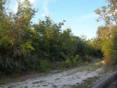
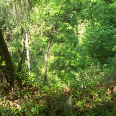
Belmore State Forest is a state forest in Clay County, Florida, consisting of two separate tracts spread across the region. The landscape includes sandhills, flatwoods, and floodplain forests that create varied natural environments.

History

The Florida Department of Agriculture created this forest to protect natural resources and provide public access to Florida's natural landscapes. The site developed as part of efforts to preserve important ecosystems for the future.

Culture

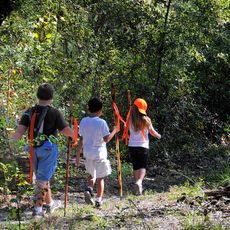
The forest serves as a gathering space where local residents participate in nature programs and outdoor education activities, building connections with the surrounding natural world.

Practical

The northern Satsuma Tract can be reached from State Road 16, while the southern Ates Creek Tract is accessible via County Road 315 and Bellamy Road. Visitors should check exact access points before heading out.

Did you know?

The forest contains nine distinct biological communities that provide habitat for protected species including gopher tortoises, Sherman's fox squirrels, and eastern indigo snakes. This diversity makes it an important refuge for rare wildlife.

Location
GPS coordinates
29.85172,-81.87720
Latest update
December 13, 2025 12:21

AroundUs brings together thousands of curated places, local tips, and hidden gems, enriched daily by 60,000 contributors worldwide. Discover all places nearby (Clay County).

Around this place
Shands Bridge
United States of America

Shands Bridge

29.1 km
Mike Roess Gold Head Branch State Park
United States of America

Mike Roess Gold Head Branch State Park

7.7 km
Etoniah Creek State Forest
United States of America

Etoniah Creek State Forest

11.8 km
Clay County Courthouse
United States of America

Clay County Courthouse

24.2 km
Middleburg United Methodist Church
United States of America

Middleburg United Methodist Church

24.1 km
St. Mary's Episcopal Church
United States of America

St. Mary's Episcopal Church

25.1 km
Old Bradford County Courthouse
United States of America

Old Bradford County Courthouse

24.7 km
Green Cove Springs Historic District
United States of America

Green Cove Springs Historic District

24.7 km
Call Street Historic District
United States of America

Call Street Historic District

24.5 km
Middleburg Historic District
United States of America

Middleburg Historic District

24.3 km
Trinity Episcopal Church
United States of America

Trinity Episcopal Church

22.3 km
Melrose Historic District
United States of America

Melrose Historic District

22.8 km
Memorial Home Community Historic District
United States of America

Memorial Home Community Historic District

16 km
Clay County Historical Museum
United States of America

Clay County Historical Museum

24.3 km
Holly Cottage
United States of America

Holly Cottage

29.4 km
Woman's Club of Starke
United States of America

Woman's Club of Starke

24.7 km
St. Mark's Episcopal Church
United States of America

St. Mark's Episcopal Church

24.4 km
Clark-Chalker House
United States of America

Clark-Chalker House

24.2 km
George A. Chalker House
United States of America

George A. Chalker House

24.1 km
Waldo Historic District
United States of America

Waldo Historic District

29.1 km
Bostwick School
United States of America

Bostwick School

25.2 km
Haskell-Long House
United States of America

Haskell-Long House

24.4 km
Frosard W. Budington House
United States of America

Frosard W. Budington House

24.2 km
Melrose Woman's Club
United States of America

Melrose Woman's Club

22.7 km
Interlachen Hall
United States of America

Interlachen Hall

25.5 km
George Randolph Frisbee, Jr. House
United States of America

George Randolph Frisbee, Jr. House

24.3 km
Florida Twin Theatre
United States of America

Florida Twin Theatre

24.7 km
Clay Theatre
United States of America

Clay Theatre

24.8 km
Show the full map
« Belmore State Forest - State forest in Clay County, Florida, United States » is provided by Around Us (aroundus.com). Images and texts are derived from Wikimedia project under a Creative Commons license. You are allowed to copy, distribute, and modify copies of this page, under the conditions set by the license, as long as this note is clearly visible.

Discover hidden gems everywhere you go!

From secret cafés to breathtaking viewpoints, skip the crowded tourist spots and find places that match your style. Our app makes it easy with voice search, smart filtering, route optimization, and insider tips from travelers worldwide. Download now for the complete mobile experience.

Around Us App Screenshot

A unique approach to discovering new places

Le Figaro

All the places worth exploring

France Info

A tailor-made excursion in just a few clicks

20 Minutes

Around Us
Travel Guide & Maps
Download

Send to your phone

QR Code
1

Open the camera app on your mobile.

2

Point at the QR code with your camera. A notification will appear.

3

Tap the notification to open the link.