Enable Location

We need your location to show you interesting places around you

Discover nearby places

Find interesting locations and hidden gems around you

Precise directions

Get accurate directions and distances to places

Your location is never shared with other users. It's only used when you tap the location button.

Log in to your account

Start exploring — it's free

Trusted by 62,530 travelers worldwide

Continue with Google
Continue with Apple
or

We will send you a code to connect

By continuing, you accept our Terms and Conditions and our Privacy Policy

Check your inbox

We've sent a pincode in your inbox. Please enter the code below.

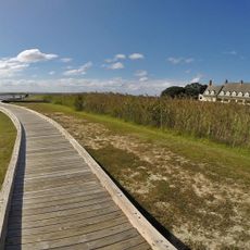
Caffeys Inlet Lifesaving Station, life saving station in Dare County, North Carolina, north of the Town of Duck

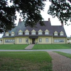
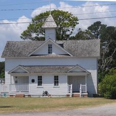
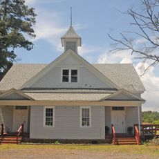
Caffeys Inlet Lifesaving Station is a historic rescue post in Dare County, North Carolina, located at a dangerous tidal inlet. The 1897 building has two stories with wooden walls, a sloped roof, and a tall observation tower rising from the center that offers wide views across the sky and water.

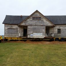
The station was built in 1874 to rescue sailors and travelers from the dangerous waters around the inlet. It remained active until about 1899 when it closed, with the 1897 replacement building surviving to the present day as the original structure no longer exists.

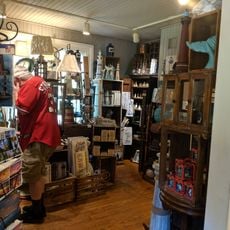
The name Caffeys Inlet refers to the dangerous waterway where the station operated. Today the 1897 building functions as a restaurant, allowing visitors to experience the space where lifesavers once worked and planned their rescues.

The building is part of the Sanderling Resort and can be visited as a restaurant. The coastal location means visitors should expect windy conditions and changing weather, so comfortable shoes are helpful.

The original 1874 building no longer exists, but the lesser-known history shows that upgrades in 1885 and 1897 made the station stronger. Many visitors overlook that the structure visible today is actually the replacement building that came after those improvements.

The community of curious travelers

AroundUs brings together thousands of curated places, local tips, and hidden gems, enriched daily by 60,000 contributors worldwide.

Start exploring
Location
Inception
1897
GPS coordinates
36.22580,-75.77080
Latest update
February 9, 2026 07:45
Around this place
Wright Brothers National Memorial
United States of America

Wright Brothers National Memorial

25.3 km
Jockey's Ridge State Park
United States of America

Jockey's Ridge State Park

31.8 km
Currituck Beach Lighthouse
United States of America

Currituck Beach Lighthouse

17.6 km
Currituck Beach Lighthouse
United States of America

Currituck Beach Lighthouse

17.6 km
Whalehead Club
United States of America

Whalehead Club

17.5 km
Wright Brothers National Memorial
United States of America

Wright Brothers National Memorial

25 km
Wright Memorial Bridge
United States of America

Wright Memorial Bridge

15.2 km
H2OBX Waterpark
United States of America

H2OBX Waterpark

13.8 km
Jarvisburg Colored School
United States of America

Jarvisburg Colored School

9.5 km
Coinjock Colored School
United States of America

Coinjock Colored School

23.3 km
Mattie Midgett Store and House
United States of America

Mattie Midgett Store and House

32.8 km
Culong
United States of America

Culong

31.4 km
Whalehead in Historic Corolla
United States of America

Whalehead in Historic Corolla

17.3 km
Queen Elizabeth I of England statue
United States of America

Queen Elizabeth I of England statue

32.5 km
Grandy School
United States of America

Grandy School

10.8 km
Wright Brothers National Memorial Visitor Center
United States of America

Wright Brothers National Memorial Visitor Center

24.6 km
Wright Brothers Monument
United States of America

Wright Brothers Monument

25.3 km
Virginia Dare Monument
United States of America

Virginia Dare Monument

32.6 km
First Flight Boulder
United States of America

First Flight Boulder

24.7 km
Fort Raleigh
United States of America

Fort Raleigh

32.5 km
December 17, 1903 Sculpture
United States of America

December 17, 1903 Sculpture

25.6 km
Waterside Theatre
United States of America

Waterside Theatre

32.4 km
First Light of Freedom Memorial
United States of America

First Light of Freedom Memorial

32.6 km
Currituck Beach
United States of America

Currituck Beach

18 km
1st Flight Marker
United States of America

1st Flight Marker

24.7 km
Elizabethan Gardens
United States of America

Elizabethan Gardens

32.5 km
3rd Flight Marker
United States of America

3rd Flight Marker

24.6 km
4th Flight Marker
United States of America

4th Flight Marker

24.5 km
Show the full map
« Caffeys Inlet Lifesaving Station - life saving station in Dare County, North Carolina, north of the Town of Duck » is provided by Around Us (aroundus.com). Images and texts are derived from Wikimedia project under a Creative Commons license. You are allowed to copy, distribute, and modify copies of this page, under the conditions set by the license, as long as this note is clearly visible.

Discover hidden gems everywhere you go!

From secret cafés to breathtaking viewpoints, skip the crowded tourist spots and find places that match your style. Our app makes it easy with voice search, smart filtering, route optimization, and insider tips from travelers worldwide. Download now for the complete mobile experience.

Around Us App Screenshot

A unique approach to discovering new places

Le Figaro

All the places worth exploring

France Info

A tailor-made excursion in just a few clicks

20 Minutes

Around Us
Travel Guide & Maps
Download

Send to your phone

QR Code
1

Open the camera app on your mobile.

2

Point at the QR code with your camera. A notification will appear.

3

Tap the notification to open the link.