Enable Location

We need your location to show you interesting places around you

Discover nearby places

Find interesting locations and hidden gems around you

Precise directions

Get accurate directions and distances to places

Your location is never shared with other users. It's only used when you tap the location button.

Ryefield Bridge

Log in to your account

Start exploring — it's free

Trusted by 62,350 travelers worldwide

Continue with Google
Continue with Apple
or

We will send you a code to connect

By continuing, you accept our Terms and Conditions and our Privacy Policy

Check your inbox

We've sent a pincode in your inbox. Please enter the code below.

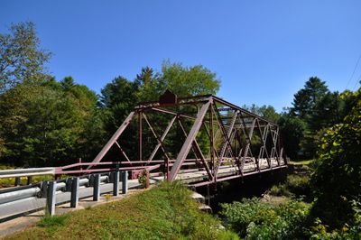
Ryefield Bridge, Road bridge in Stuart's Corner, Maine, United States

Ryefield Bridge is a road bridge spanning across the Crooked River in Maine that links Harrison and Otisfield. It is built with steel beams supporting a wooden roadway and rests on solid granite abutments.

This structure was built in 1912 by the American Bridge Company using a Warren truss design. The double-intersection diagonal pattern was a proven engineering approach chosen to enhance structural stability.

The bridge connects two communities and shows how people in this area built their infrastructure to bring towns closer together. Its design reflects how much care local builders put into engineering solutions that would serve the region for many years.

The bridge is accessible by vehicle and connects Ryefield Bridge Road with West Andrew Hill Road. It provides adequate width for traffic flow and is straightforward to reach when traveling in this rural area.

This structure ranks among Maine's few Warren truss bridges built before 1916 and features manufacturer plaques at its entrances. These plaques serve as records of the craftsmanship and clearly display when the work was completed.

The community of curious travelers

AroundUs brings together thousands of curated places, local tips, and hidden gems, enriched daily by 60,000 contributors worldwide.

Start exploring
Location
GPS coordinates
44.14280,-70.59530
Latest update
December 14, 2025 18:03
Around this place
Oxford Casino
United States of America

Oxford Casino

12.3 km
Deertrees Theatre
United States of America

Deertrees Theatre

6.2 km
William F. Perry House
United States of America

William F. Perry House

13.7 km
Bell Hill School
United States of America

Bell Hill School

6.8 km
Bell Hill Meetinghouse
United States of America

Bell Hill Meetinghouse

6.7 km
Walker Memorial Hall
United States of America

Walker Memorial Hall

12.5 km
Center Meeting House and Common
United States of America

Center Meeting House and Common

9.9 km
Sturtevant Hall
United States of America

Sturtevant Hall

16.2 km
Waterford Historic District
United States of America

Waterford Historic District

10.6 km
Benjamin Cleaves House
United States of America

Benjamin Cleaves House

14.7 km
John and Maria Webb House
United States of America

John and Maria Webb House

13.4 km
Samuel Penney House
United States of America

Samuel Penney House

16.3 km
Paris Public Library
United States of America

Paris Public Library

11 km
Nutting Homestead
United States of America

Nutting Homestead

9 km
Hersey Plow Company Building
United States of America

Hersey Plow Company Building

11.3 km
McLaughlin House and Garden
United States of America

McLaughlin House and Garden

10.5 km
Scribner Homestead
United States of America

Scribner Homestead

6.4 km
Dalton Holmes Davis Memorial Library
United States of America

Dalton Holmes Davis Memorial Library

13.5 km
Norway Historic District
United States of America

Norway Historic District

9 km
Robinson-Parsons Farm
United States of America

Robinson-Parsons Farm

9.3 km
Levi Sargent House
United States of America

Levi Sargent House

2.6 km
Lakeside Grange No. 63
United States of America

Lakeside Grange No. 63

7.8 km
Caswell Public Library
United States of America

Caswell Public Library

7.7 km
McWain-Hall House
United States of America

McWain-Hall House

7.7 km
Elisha F. Stone House
United States of America

Elisha F. Stone House

11.1 km
Former Otisfield Town House
United States of America

Former Otisfield Town House

7.6 km
United States of America

Thompson Lake

11.6 km
United States of America

Highland Lake

13.5 km
Show the full map
« Ryefield Bridge - Road bridge in Stuart's Corner, Maine, United States » is provided by Around Us (aroundus.com). Images and texts are derived from Wikimedia project under a Creative Commons license. You are allowed to copy, distribute, and modify copies of this page, under the conditions set by the license, as long as this note is clearly visible.

Discover hidden gems everywhere you go!

From secret cafés to breathtaking viewpoints, skip the crowded tourist spots and find places that match your style. Our app makes it easy with voice search, smart filtering, route optimization, and insider tips from travelers worldwide. Download now for the complete mobile experience.

Around Us App Screenshot

A unique approach to discovering new places

Le Figaro

All the places worth exploring

France Info

A tailor-made excursion in just a few clicks

20 Minutes

Around Us
Travel Guide & Maps
Download

Send to your phone

QR Code
1

Open the camera app on your mobile.

2

Point at the QR code with your camera. A notification will appear.

3

Tap the notification to open the link.