Enable Location

We need your location to show you interesting places around you

Discover nearby places

Find interesting locations and hidden gems around you

Precise directions

Get accurate directions and distances to places

Your location is never shared with other users. It's only used when you tap the location button.

Babb's Bridge

Log in to your account

Start exploring — it's free

Trusted by 61,345 travelers worldwide

Continue with Google
Continue with Apple
or

We will send you a code to connect

By continuing, you accept our Terms and Conditions and our Privacy Policy

Check your inbox

We've sent a pincode in your inbox. Please enter the code below.

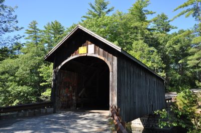
Babb's Bridge, Covered bridge in Cumberland County, United States.

Description

Babb's Bridge is a wooden covered bridge that crosses the Presumpscot River and joins Gorham to Windham. The structure features a single span with a traditional timber truss design typical of New England construction methods.

History

The original bridge was built in 1864 and stood until a fire destroyed it in 1973. It was rebuilt in 1976 using traditional construction methods to restore its historical form.

Culture

The bridge represents local engineering traditions of the 19th century, demonstrating the importance of covered bridges in New England transportation networks.

Practical

Heavy vehicles and oversized trucks should not attempt to cross this bridge due to weight and height restrictions. It is wise to check conditions before traveling and avoid commercial or large transport.

Did you know?

A dump truck carrying gravel severely damaged the deck in 2024 by exceeding the weight limit. This incident revealed how vulnerable this historic structure is to modern traffic loads.

Inception
1864
GPS coordinates
43.76610,-70.44810
Latest update
December 13, 2025 11:44

AroundUs brings together thousands of curated places, local tips, and hidden gems, enriched daily by 60,000 contributors worldwide. Discover all places nearby (Cumberland County).

Around this place
Sebago Lake
United States of America

Sebago Lake

13.3 km
United States of America

Gorham Academy

9.4 km
McLellan House
United States of America

McLellan House

9 km
Marrett House
United States of America

Marrett House

8.9 km
Maplewood Farm
United States of America

Maplewood Farm

7.5 km
Baxter House
United States of America

Baxter House

9.9 km
Walker Memorial Library
United States of America

Walker Memorial Library

12.1 km
Baxter Memorial Library
United States of America

Baxter Memorial Library

9.9 km
Vallee Family House
United States of America

Vallee Family House

12.5 km
Academy Building
United States of America

Academy Building

9.4 km
Great Falls Historic District
United States of America

Great Falls Historic District

4.1 km
Gorham Campus Historic District
United States of America

Gorham Campus Historic District

9.5 km
Goold House
United States of America

Goold House

4.3 km
Parson Smith House
United States of America

Parson Smith House

7.1 km
Paine Neighborhood Historic District
United States of America

Paine Neighborhood Historic District

12.6 km
Isaac W. Dyer Estate
United States of America

Isaac W. Dyer Estate

8.7 km
Old Westbrook High School
United States of America

Old Westbrook High School

12.1 km
Gorham Historic District
United States of America

Gorham Historic District

9.6 km
University of Southern Maine Art Gallery
United States of America

University of Southern Maine Art Gallery

9.6 km
First Parish Meetinghouse
United States of America

First Parish Meetinghouse

9.2 km
Freeman Farm Historic District
United States of America

Freeman Farm Historic District

11.1 km
Falmouth House
United States of America

Falmouth House

11.8 km
Stephen Longfellow House
United States of America

Stephen Longfellow House

11.6 km
Hall's Tavern
United States of America

Hall's Tavern

11.8 km
Elisha Purington House
United States of America

Elisha Purington House

8.4 km
Standish Corner Historic District
United States of America

Standish Corner Historic District

9 km
Nathan Harris House
United States of America

Nathan Harris House

12.4 km
Cumberland Mills Historic District
United States of America

Cumberland Mills Historic District

12.1 km
Show the full map
« Babb's Bridge - Covered bridge in Cumberland County, United States » is provided by Around Us (aroundus.com). Images and texts are derived from Wikimedia project under a Creative Commons license. You are allowed to copy, distribute, and modify copies of this page, under the conditions set by the license, as long as this note is clearly visible.

Discover hidden gems everywhere you go!

From secret cafés to breathtaking viewpoints, skip the crowded tourist spots and find places that match your style. Our app makes it easy with voice search, smart filtering, route optimization, and insider tips from travelers worldwide. Download now for the complete mobile experience.

Around Us App Screenshot

A unique approach to discovering new places

Le Figaro

All the places worth exploring

France Info

A tailor-made excursion in just a few clicks

20 Minutes

Around Us
Travel Guide & Maps
Download

Send to your phone

QR Code
1

Open the camera app on your mobile.

2

Point at the QR code with your camera. A notification will appear.

3

Tap the notification to open the link.