Chest opened
+${chestReward.xp} XP
Explorer
NOUVEAU ×${chestReward.collectible.quantity}
tapez pour fermer
Chest locked

Open chests in the app

Around Us is built for your phone — chests unlock when you walk, explore and capture nearby places.

Enable Location

We need your location to show you interesting places around you

Discover nearby places

Find interesting locations and hidden gems around you

Precise directions

Get accurate directions and distances to places

Your location is never shared with other users. It's only used when you tap the location button.

Log in to your account

Start exploring — it's free

Trusted by 72,882 travelers worldwide

Continue with Google
Continue with Apple
or

We will send you a code to connect

By continuing, you accept our Terms and Conditions and our Privacy Policy

Check your inbox

We've sent a pincode in your inbox. Please enter the code below.

Discussion Reviews Photo
1.6k Popularity

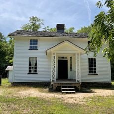
Fairntosh Plantation, Historic plantation complex in Durham County, North Carolina, United States.

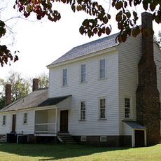
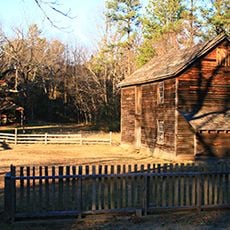
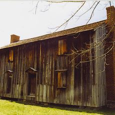
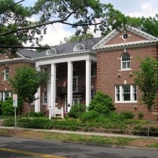
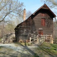
Fairntosh Plantation is a historic complex of two main houses built in Georgian and Federal styles and arranged in a T-shaped configuration across 100 acres. Several ancillary buildings are scattered across the property, each serving distinct functional purposes on the grounds.

Duncan Cameron established the plantation in 1810 and developed it into a center of agricultural production in the region. The estate's operations depended on the forced labor of enslaved people.

The buildings on the property show how life was organized across different roles and classes during the antebellum period. Visitors can observe how each structure served specific purposes and how the daily routines unfolded across the plantation grounds.

The property is located near the intersection of State Routes 1004 and 1632, making it accessible by car. Guided tours are the main way to explore the buildings and learn about the site's history.

The main house blends two distinct architectural layouts: the rear section features a side hall plan while the front has a center hall design. This combination reveals how the building evolved and was expanded over different periods.

The community of curious travelers

AroundUs brings together thousands of curated places, local tips, and hidden gems, enriched daily by 60,000 contributors worldwide.

Start exploring
Location
GPS coordinates
36.09890,-78.82830
Latest update
December 14, 2025 13:01
Around this place
Museum of Life and Science
United States of America

Museum of Life and Science

10 km
Stagville
United States of America

Stagville

2.2 km
Duke Homestead and Tobacco Factory
United States of America

Duke Homestead and Tobacco Factory

11 km
West Point on the Eno
United States of America

West Point on the Eno

7.9 km
Horton Grove
United States of America

Horton Grove

3.2 km
Russell School
United States of America

Russell School

10.9 km
Trinity Historic District
United States of America

Trinity Historic District

12.8 km
West Point Mill
United States of America

West Point Mill

7.9 km
Wright's Automatic Machinery Company
United States of America

Wright's Automatic Machinery Company

12.6 km
Bullington Warehouse
United States of America

Bullington Warehouse

12.8 km
Ephphatha Church
United States of America

Ephphatha Church

12.1 km
Watts-Hillandale Historic District
United States of America

Watts-Hillandale Historic District

12.6 km
Bassett House
United States of America

Bassett House

12.8 km
Pearl Mill Village Historic District
United States of America

Pearl Mill Village Historic District

12.4 km
Foster and West Geer Streets Historic District
United States of America

Foster and West Geer Streets Historic District

12.5 km
Lakewood Park Historic District
United States of America

Lakewood Park Historic District

12.6 km
Crowell House
United States of America

Crowell House

12.8 km
Liberty Warehouse Nos. 1 and 2
United States of America

Liberty Warehouse Nos. 1 and 2

12.6 km
City Garage Yard and Fire Drill Tower
United States of America

City Garage Yard and Fire Drill Tower

12.3 km
Cleveland Street District
United States of America

Cleveland Street District

12.6 km
Cranford-Wannamaker House
United States of America

Cranford-Wannamaker House

12.7 km
Pegram House
United States of America

Pegram House

12.8 km
North Durham-Duke Park District
United States of America

North Durham-Duke Park District

11.9 km
West Durham Historic District
United States of America

West Durham Historic District

12.4 km
Dillard-Gamble Houses
United States of America

Dillard-Gamble Houses

11.6 km
Kinchen Holloway House
United States of America

Kinchen Holloway House

9.9 km
Duke Homestead Tobacco Museum
United States of America

Duke Homestead Tobacco Museum

10.9 km
Stadium 10 at Northgate
United States of America

Stadium 10 at Northgate

11.4 km
Show the full map
Reviews
Share your experience

No review yet

Discussions
Start a discussion...

No discussion yet

« Fairntosh Plantation - Historic plantation complex in Durham County, North Carolina, United States » is provided by Around Us (aroundus.com). Images and texts are derived from Wikimedia project under a Creative Commons license. You are allowed to copy, distribute, and modify copies of this page, under the conditions set by the license, as long as this note is clearly visible.

Discover hidden gems everywhere you go!

From secret cafés to breathtaking viewpoints, skip the crowded tourist spots and find places that match your style. Our app makes it easy with voice search, smart filtering, route optimization, and insider tips from travelers worldwide. Download now for the complete mobile experience.

Around Us App Screenshot

A unique approach to discovering new places

Le Figaro

All the places worth exploring

France Info

A tailor-made excursion in just a few clicks

20 Minutes

Around Us
Travel Guide & Maps
Download

Send to your phone

QR Code
1

Open the camera app on your mobile.

2

Point at the QR code with your camera. A notification will appear.

3

Tap the notification to open the link.