Enable Location

We need your location to show you interesting places around you

Discover nearby places

Find interesting locations and hidden gems around you

Precise directions

Get accurate directions and distances to places

Your location is never shared with other users. It's only used when you tap the location button.

Gay City State Park

Log in to your account

Start exploring — it's free

Trusted by 62,557 travelers worldwide

Continue with Google
Continue with Apple
or

We will send you a code to connect

By continuing, you accept our Terms and Conditions and our Privacy Policy

Check your inbox

We've sent a pincode in your inbox. Please enter the code below.

Gay City State Park

Gay City State Park, recreation area in Connecticut, United States

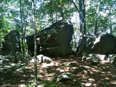
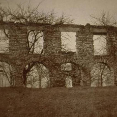
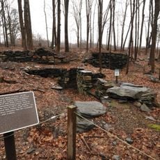
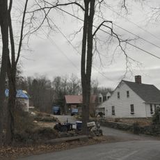
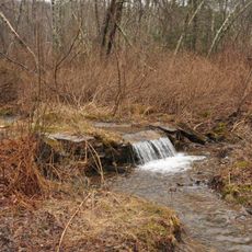
Gay City State Park is a Connecticut state park with trails winding through forests and open spaces. The property contains ruins and foundations from the early settlement, including remains of mills and homes that are scattered throughout the wooded landscape.

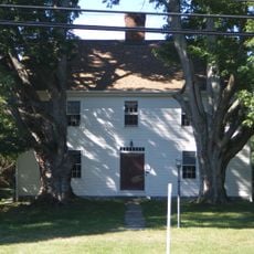
The community was established in 1796 by a religiously motivated group led by Elijah Andrus, with later leadership under Reverend Henry P. Sumner. The settlement declined around the time of the Civil War as the population dwindled and residents eventually moved away.

The name Gay City came from an early landowner and reflects the community that once thrived here. Visitors walking the trails can spot remnants of old foundations and mill structures scattered through the woods, offering glimpses into how residents organized their daily lives.

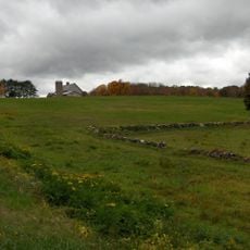
The park has hiking trails that wind through the woods and past the old ruins. Visitors should wear sturdy footwear and expect uneven ground as the paths pass through natural terrain and around the historical foundations.

Several old mills in the park burned down during different periods of American history, contributing to the community's decline. These losses represent a turning point in why residents eventually abandoned the settlement.

The community of curious travelers

AroundUs brings together thousands of curated places, local tips, and hidden gems, enriched daily by 60,000 contributors worldwide.

Start exploring
Location
Inception
1944
GPS coordinates
41.72611,-72.44000
Latest update
February 7, 2026 11:01
Around this place
Cheney Brothers Historic District
United States of America

Cheney Brothers Historic District

8.3 km
Marlborough Tavern
United States of America

Marlborough Tavern

10.7 km
Lutz Children's Museum
United States of America

Lutz Children's Museum

7.4 km
Pitkin Glassworks Ruin
United States of America

Pitkin Glassworks Ruin

7.7 km
Strong House
United States of America

Strong House

8.8 km
Manchester Main Post Office
United States of America

Manchester Main Post Office

8.8 km
Fifth Camp of Rochambeau's Infantry
United States of America

Fifth Camp of Rochambeau's Infantry

5 km
White's Tavern
United States of America

White's Tavern

4.7 km
Willimantic Elks Club
United States of America

Willimantic Elks Club

9 km
Oliver White Tavern
United States of America

Oliver White Tavern

5 km
Case Brothers Historic District
United States of America

Case Brothers Historic District

5.8 km
Elias Sprague House
United States of America

Elias Sprague House

9.3 km
Augustus Post House
United States of America

Augustus Post House

9.8 km
Andover Center Historic District
United States of America

Andover Center Historic District

5.5 km
Bolton Green Historic District
United States of America

Bolton Green Historic District

5.2 km
Hebron Center Historic District
United States of America

Hebron Center Historic District

9.7 km
Union Village Historic District
United States of America

Union Village Historic District

10.7 km
Loomis-Pomeroy House
United States of America

Loomis-Pomeroy House

9.6 km
Coventry Glass Factory Historic District
United States of America

Coventry Glass Factory Historic District

11 km
Manchester Historic District
United States of America

Manchester Historic District

8.8 km
Valley Falls Cotton Mill Site
United States of America

Valley Falls Cotton Mill Site

10.6 km
Dr. Elizur Hale House
United States of America

Dr. Elizur Hale House

2.7 km
Parker-Hutchinson Farm
United States of America

Parker-Hutchinson Farm

9.9 km
Sharpe's Trout Hatchery Site
United States of America

Sharpe's Trout Hatchery Site

10.6 km
Woodbridge Farmstead
United States of America

Woodbridge Farmstead

8.2 km
Marlborough Congregational Church
United States of America

Marlborough Congregational Church

10.9 km
Nathan Hale Homestead
United States of America

Nathan Hale Homestead

8.9 km
Manchester Country Club
United States of America

Manchester Country Club

6.4 km
Show the full map
« Gay City State Park - recreation area in Connecticut, United States » is provided by Around Us (aroundus.com). Images and texts are derived from Wikimedia project under a Creative Commons license. You are allowed to copy, distribute, and modify copies of this page, under the conditions set by the license, as long as this note is clearly visible.

Discover hidden gems everywhere you go!

From secret cafés to breathtaking viewpoints, skip the crowded tourist spots and find places that match your style. Our app makes it easy with voice search, smart filtering, route optimization, and insider tips from travelers worldwide. Download now for the complete mobile experience.

Around Us App Screenshot

A unique approach to discovering new places

Le Figaro

All the places worth exploring

France Info

A tailor-made excursion in just a few clicks

20 Minutes

Around Us
Travel Guide & Maps
Download

Send to your phone

QR Code
1

Open the camera app on your mobile.

2

Point at the QR code with your camera. A notification will appear.

3

Tap the notification to open the link.