·

Enable Location

We need your location to show you interesting places around you

Discover nearby places

Find interesting locations and hidden gems around you

Precise directions

Get accurate directions and distances to places

Your location is never shared with other users. It's only used when you tap the location button.

Frederiksted Pier

Log in to your account

Start exploring — it's free

Trusted by 62,653 travelers worldwide

Continue with Google
Continue with Apple
or

We will send you a code to connect

By continuing, you accept our Terms and Conditions and our Privacy Policy

Check your inbox

We've sent a pincode in your inbox. Please enter the code below.

Frederiksted Pier

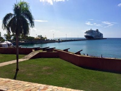
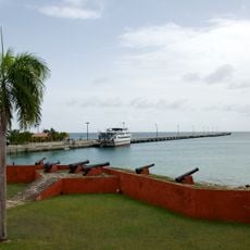
Frederiksted Pier, cruise ship pier in Saint Croix, U.S. Virgin Islands

Frederiksted Pier is a long dock extending into the ocean that serves as a ship docking point and a popular snorkeling and diving location. The structure features coral-covered pylons that create an underwater environment full of fish and sea creatures.

The pier was built in the early 1900s and underwent major renovation in the early 2000s that transformed its appearance and function. This upgrade made the waterfront more attractive and improved its role as both a port facility and visitor destination.

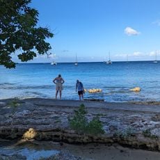
The pier is a gathering spot for locals, especially at sunset when families and couples watch the sky change colors. Jumping from a designated area is a local tradition that shows how people connect with the water and share this experience.

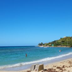
The pier is located right in the center of Frederiksted town along Strand Street with parking available nearby, making it easy to access. Entry into the water is possible from a small sandy beach on the left side or over rocks, and wearing diving booties and sturdy fins is recommended to protect your feet from slippery surfaces and barnacles.

Night divers report encountering octopuses, lobsters, and other sea creatures that are more active after dark, revealing a completely different underwater world. This nocturnal activity creates an exciting alternative to daytime snorkeling and shows the hidden life beneath the pier.

The community of curious travelers

AroundUs brings together thousands of curated places, local tips, and hidden gems, enriched daily by 60,000 contributors worldwide.

Start exploring
Location
GPS coordinates
17.71394,-64.88835
Latest update
February 9, 2026 08:23
Around this place
Salt River Bay National Historical Park and Ecological Preserve
United States of America

Salt River Bay National Historical Park and Ecological Preserve

15.5 km
Sandy Point National Wildlife Refuge
United States of America

Sandy Point National Wildlife Refuge

4.2 km
Fort Frederik
United States of America

Fort Frederik

539 m
United States of America

Mount Eagle

9.7 km
St. George Village Botanical Garden
United States of America

St. George Village Botanical Garden

5.6 km
Hams Bluff Light
United States of America

Hams Bluff Light

6.7 km
Estate Judith's Fancy
United States of America

Estate Judith's Fancy

16.7 km
Frederiksted Historic District
United States of America

Frederiksted Historic District

334 m
Slob Historic District
United States of America

Slob Historic District

11.6 km
Estate Saint George Historic District
United States of America

Estate Saint George Historic District

6.2 km
Caribbean Museum Center for the Arts
United States of America

Caribbean Museum Center for the Arts

550 m
Rainbow Beach
United States of America

Rainbow Beach

2.3 km
Den hellige treenighetskirke
United States of America

Den hellige treenighetskirke

906 m
Cane Bay Beach
United States of America

Cane Bay Beach

10.7 km
Sandy Point Beach
United States of America

Sandy Point Beach

4.4 km
LaGrange Beach
United States of America

LaGrange Beach

922 m
Cormorant Beach Club
United States of America

Cormorant Beach Club

16.9 km
Carlton Beach
United States of America

Carlton Beach

6.8 km
Monks Bath Beach
United States of America

Monks Bath Beach

5.4 km
Saint Croix Country Club Beach
United States of America

Saint Croix Country Club Beach

720 m
Judiths Fancy Beach
United States of America

Judiths Fancy Beach

16.9 km
Pelican Cove Beach
United States of America

Pelican Cove Beach

17.2 km
Frederiksted Beach
United States of America

Frederiksted Beach

478 m
Davis Beach
United States of America

Davis Beach

8 km
Cathys Fancy Beach
United States of America

Cathys Fancy Beach

18.1 km
Sprat Hall Beach
United States of America

Sprat Hall Beach

3.1 km
West Beach
United States of America

West Beach

2.3 km
Salt River Beach
United States of America

Salt River Beach

15.4 km
Show the full map
« Frederiksted Pier - cruise ship pier in Saint Croix, U.S. Virgin Islands » is provided by Around Us (aroundus.com). Images and texts are derived from Wikimedia project under a Creative Commons license. You are allowed to copy, distribute, and modify copies of this page, under the conditions set by the license, as long as this note is clearly visible.

Discover hidden gems everywhere you go!

From secret cafés to breathtaking viewpoints, skip the crowded tourist spots and find places that match your style. Our app makes it easy with voice search, smart filtering, route optimization, and insider tips from travelers worldwide. Download now for the complete mobile experience.

Around Us App Screenshot

A unique approach to discovering new places

Le Figaro

All the places worth exploring

France Info

A tailor-made excursion in just a few clicks

20 Minutes

Around Us
Travel Guide & Maps
Download

Send to your phone

QR Code
1

Open the camera app on your mobile.

2

Point at the QR code with your camera. A notification will appear.

3

Tap the notification to open the link.