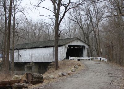
Darlington Covered Bridge, Covered bridge in Montgomery County, US.
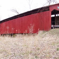
The Darlington Covered Bridge is a wooden covered structure that spans Sugar Creek using a Howe truss design that combines wood beams and metal reinforcements. Stone supports anchor the bridge at each end, creating a stable connection across the water that measures approximately 166 feet in length.
The bridge was built in 1868 by superintendent Richard M. Epperson and builder Joseph Kress using donations and materials from the local area. It served as a vital transportation link for the region until vehicle traffic ended in 1976.
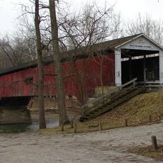
The bridge takes its name from a nearby family that was prominent in the area during its construction period. Today visitors can see how communities in the 1800s invested in sturdy wooden structures that connected their neighborhoods and farms.
The bridge is located at the intersection of County Roads 500 North and 600 East in a rural area that is calm and accessible for viewing. Since it no longer carries traffic, visitors can walk near or around the structure to examine its design and construction methods.
The bridge was constructed using oak and poplar wood sourced from trees in the surrounding area, both species chosen for their strength and availability. This local material selection shows how builders worked with what nature provided nearby rather than importing timber from distant locations.
The community of curious travelers
AroundUs brings together thousands of curated places, local tips, and hidden gems, enriched daily by 60,000 contributors worldwide.