Enable Location

We need your location to show you interesting places around you

Discover nearby places

Find interesting locations and hidden gems around you

Precise directions

Get accurate directions and distances to places

Your location is never shared with other users. It's only used when you tap the location button.

Grist Mill Bridge, Dam and Mill Site

Log in to your account

Start exploring — it's free

Trusted by 62,818 travelers worldwide

Continue with Google
Continue with Apple
or

We will send you a code to connect

By continuing, you accept our Terms and Conditions and our Privacy Policy

Check your inbox

We've sent a pincode in your inbox. Please enter the code below.

Grist Mill Bridge, Dam and Mill Site

Grist Mill Bridge, Dam and Mill Site, Historic mill complex in Duplain Township, United States

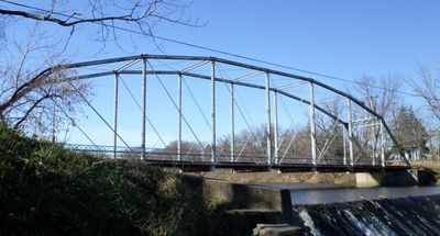
Grist Mill Bridge, Dam and Mill Site comprises three distinct structures: a metal truss bridge on Upton Road, a dam that created a mill pond, and the foundation remains of the Kellogg Bros. & Johnson Mill. The site now functions as a park where visitors can observe the remnants of this working industrial landscape.

The site began in 1865 when Kellogg Bros. & Johnson purchased the property and converted an existing sawmill into a flour and grain mill. This transformation expanded production capacity and established the complex as a major processing center for the region.

The mill complex served as a gathering place where local farmers brought grain to be processed and connected with neighbors. This site anchored the agricultural economy of the township, making it central to how farming families organized their work and trade.

The site is now a public park maintained by Duplain Township and the Elsie Lions Club, freely accessible to visitors. Walking around the grounds works best in fair weather, allowing you to see all three structures comfortably.

The Upton Road Bridge stands as one of Michigan's last metal truss highway bridges and was built by the Detroit Bridge & Iron Works company. This 19th century engineering structure reveals the technical skill of that era and remains a rare survivor of its design type.

The community of curious travelers

AroundUs brings together thousands of curated places, local tips, and hidden gems, enriched daily by 60,000 contributors worldwide.

Start exploring
Location
GPS coordinates
43.09000,-84.40583
Latest update
December 14, 2025 17:02
Around this place
Sleepy Hollow State Park
United States of America

Sleepy Hollow State Park

16.9 km
First Congregational Church of Ovid
United States of America

First Congregational Church of Ovid

9.7 km
East Ward School
United States of America

East Ward School

15.3 km
Oliver Street Historic District
United States of America

Oliver Street Historic District

21.3 km
Union School
United States of America

Union School

16.3 km
Amos Gould House
United States of America

Amos Gould House

21.3 km
Elias Comstock Cabin
United States of America

Elias Comstock Cabin

21.3 km
Lyman Woodard Company Workers' Housing
United States of America

Lyman Woodard Company Workers' Housing

21.2 km
Christian-Ellis House
United States of America

Christian-Ellis House

21.3 km
Nathan Ayres House
United States of America

Nathan Ayres House

21.3 km
Ebenezer Gould House
United States of America

Ebenezer Gould House

21.2 km
Edwin Todd House
United States of America

Edwin Todd House

21.2 km
Sylvester Opdyke House
United States of America

Sylvester Opdyke House

21 km
Alfred Williams House
United States of America

Alfred Williams House

21.3 km
Albert Palmer House
United States of America

Albert Palmer House

21.1 km
George Perrigo House
United States of America

George Perrigo House

20.8 km
Frederick Frieseke Birthplace and Boyhood Home
United States of America

Frederick Frieseke Birthplace and Boyhood Home

21.2 km
Benjamin Williams House
United States of America

Benjamin Williams House

21.3 km
Eugene Jacobs House
United States of America

Eugene Jacobs House

21.2 km
House at 314 W. King St.
United States of America

House at 314 W. King St.

21.1 km
Selden Miner House
United States of America

Selden Miner House

21 km
Saint John's Church Historical Marker
United States of America

Saint John's Church Historical Marker

15.5 km
St. Johns Cinema
United States of America

St. Johns Cinema

15 km
Saint Johns
United States of America

Saint Johns

15.9 km
Clinton Theater
United States of America

Clinton Theater

15.9 km
Paine-Gillam-Scott House Historical Marker
United States of America

Paine-Gillam-Scott House Historical Marker

16 km
Briggs Public Library
United States of America

Briggs Public Library

15.6 km
Lake Ovid
United States of America

Lake Ovid

17.3 km
Show the full map
« Grist Mill Bridge, Dam and Mill Site - Historic mill complex in Duplain Township, United States » is provided by Around Us (aroundus.com). Images and texts are derived from Wikimedia project under a Creative Commons license. You are allowed to copy, distribute, and modify copies of this page, under the conditions set by the license, as long as this note is clearly visible.

Discover hidden gems everywhere you go!

From secret cafés to breathtaking viewpoints, skip the crowded tourist spots and find places that match your style. Our app makes it easy with voice search, smart filtering, route optimization, and insider tips from travelers worldwide. Download now for the complete mobile experience.

Around Us App Screenshot

A unique approach to discovering new places

Le Figaro

All the places worth exploring

France Info

A tailor-made excursion in just a few clicks

20 Minutes

Around Us
Travel Guide & Maps
Download

Send to your phone

QR Code
1

Open the camera app on your mobile.

2

Point at the QR code with your camera. A notification will appear.

3

Tap the notification to open the link.