Enable Location

We need your location to show you interesting places around you

Discover nearby places

Find interesting locations and hidden gems around you

Precise directions

Get accurate directions and distances to places

Your location is never shared with other users. It's only used when you tap the location button.

Sleepy Hollow State Park

Log in to your account

Start exploring — it's free

Trusted by 62,822 travelers worldwide

Continue with Google
Continue with Apple
or

We will send you a code to connect

By continuing, you accept our Terms and Conditions and our Privacy Policy

Check your inbox

We've sent a pincode in your inbox. Please enter the code below.

Sleepy Hollow State Park

Sleepy Hollow State Park, State park in Clinton County, Michigan.

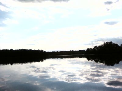
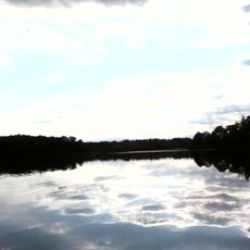
Sleepy Hollow State Park is a 2,600-acre park in Clinton County centered around Lake Ovid, which was created by damming the Little Maple River. The water body sits surrounded by woods and open fields that make up the park's landscape.

The park was established in May 1976 as a new outdoor recreation area for Michigan. Over the following years it expanded with modern camping facilities and trail networks to serve more visitors.

The park hosts community events throughout the year, connecting residents with nature through educational programs and seasonal outdoor activities in the Michigan wilderness.

The park offers 16 miles of hiking trails and 6.5 miles of horseback riding paths for outdoor activities. Visitors can also reserve specialized hunting blinds, including options with hydraulic lifts for accessibility.

The park maintains a dedicated metal detecting zone where visitors can search for items in the ground. It also provides free beach wheelchairs and mobility scooters to help all visitors access the lake.

The community of curious travelers

AroundUs brings together thousands of curated places, local tips, and hidden gems, enriched daily by 60,000 contributors worldwide.

Start exploring
Location
Location
Inception
May 1976
GPS coordinates
42.93860,-84.41280
Latest update
December 9, 2025 18:44
Around this place
Curwood Castle
United States of America

Curwood Castle

20.3 km
Grist Mill Bridge, Dam and Mill Site
United States of America

Grist Mill Bridge, Dam and Mill Site

16.9 km
First Congregational Church of Ovid
United States of America

First Congregational Church of Ovid

8.3 km
East Ward School
United States of America

East Ward School

13.1 km
Stony Creek Bridge
United States of America

Stony Creek Bridge

13.9 km
Lincoln School
United States of America

Lincoln School

20.5 km
Oliver Street Historic District
United States of America

Oliver Street Historic District

20.7 km
Union School
United States of America

Union School

13.7 km
Elias Comstock Cabin
United States of America

Elias Comstock Cabin

20.5 km
Lyman Woodard Company Workers' Housing
United States of America

Lyman Woodard Company Workers' Housing

20.1 km
Charles H. Calkins House
United States of America

Charles H. Calkins House

20.4 km
Ebenezer Gould House
United States of America

Ebenezer Gould House

20.2 km
Hezekiah W. and Sarah E. Fishell Cobb House
United States of America

Hezekiah W. and Sarah E. Fishell Cobb House

20.2 km
Edwin Todd House
United States of America

Edwin Todd House

20.7 km
Sylvester Opdyke House
United States of America

Sylvester Opdyke House

20.6 km
William Horton Farmhouse
United States of America

William Horton Farmhouse

19.4 km
Albert Palmer House
United States of America

Albert Palmer House

20.2 km
George Perrigo House
United States of America

George Perrigo House

20 km
Michigan Avenue-Genesee Street Historic Residential District
United States of America

Michigan Avenue-Genesee Street Historic Residential District

20.3 km
Selden Miner House
United States of America

Selden Miner House

20.7 km
Saint John's Church Historical Marker
United States of America

Saint John's Church Historical Marker

13.5 km
St. Johns Cinema
United States of America

St. Johns Cinema

14.1 km
Gunnisonville United Methodist Church Historical Marker
United States of America

Gunnisonville United Methodist Church Historical Marker

16.6 km
Saint Johns
United States of America

Saint Johns

13.8 km
Clinton Theater
United States of America

Clinton Theater

13.8 km
Paine-Gillam-Scott House Historical Marker
United States of America

Paine-Gillam-Scott House Historical Marker

13.8 km
Briggs Public Library
United States of America

Briggs Public Library

13.9 km
Lake Ovid
United States of America

Lake Ovid

461 m
Show the full map
« Sleepy Hollow State Park - State park in Clinton County, Michigan » is provided by Around Us (aroundus.com). Images and texts are derived from Wikimedia project under a Creative Commons license. You are allowed to copy, distribute, and modify copies of this page, under the conditions set by the license, as long as this note is clearly visible.

Discover hidden gems everywhere you go!

From secret cafés to breathtaking viewpoints, skip the crowded tourist spots and find places that match your style. Our app makes it easy with voice search, smart filtering, route optimization, and insider tips from travelers worldwide. Download now for the complete mobile experience.

Around Us App Screenshot

A unique approach to discovering new places

Le Figaro

All the places worth exploring

France Info

A tailor-made excursion in just a few clicks

20 Minutes

Around Us
Travel Guide & Maps
Download

Send to your phone

QR Code
1

Open the camera app on your mobile.

2

Point at the QR code with your camera. A notification will appear.

3

Tap the notification to open the link.