Enable Location

We need your location to show you interesting places around you

Discover nearby places

Find interesting locations and hidden gems around you

Precise directions

Get accurate directions and distances to places

Your location is never shared with other users. It's only used when you tap the location button.

Log in to your account

Start exploring — it's free

Trusted by 62,561 travelers worldwide

Continue with Google
Continue with Apple
or

We will send you a code to connect

By continuing, you accept our Terms and Conditions and our Privacy Policy

Check your inbox

We've sent a pincode in your inbox. Please enter the code below.

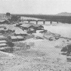
Antelope Hill Highway Bridge, bridge in United States of America

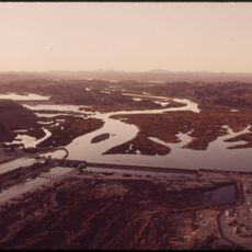
The Antelope Hill Highway Bridge is a concrete bridge crossing the Gila River in Tacna, Arizona. Built as a twin concrete girder structure with ten spans and nearly 1000 feet in length, it was designed to connect the route between Yuma and Phoenix when completed in 1915.

Construction began in 1914 with completion in 1915, utilizing prison labor from the Arizona State Penitentiary. Major floods in 1919 and 1920 severely damaged the structure, prompting officials to establish a new route through Gila Bend with a different bridge, after which this crossing was abandoned by 1929.

The bridge is no longer accessible by vehicle but can be reached on foot via Roll Road if visitors are prepared for rough conditions and dry terrain. No facilities such as restrooms or parking are available nearby, so visitors should bring water and check for flooding conditions before approaching.

This is one of only three remaining twin concrete girder bridges in Arizona and was constructed using labor from the Arizona State Penitentiary. The unusual dual concrete beam design represented an innovative structure for its time, showcasing early experiments with concrete in early 20th-century bridge engineering.

The community of curious travelers

AroundUs brings together thousands of curated places, local tips, and hidden gems, enriched daily by 60,000 contributors worldwide.

Start exploring
Location
GPS coordinates
32.71889,-114.01194
Latest update
February 9, 2026 07:40
Around this place
Yuma Territorial Prison
United States of America

Yuma Territorial Prison

56.4 km
All-American Canal
United States of America

All-American Canal

46.5 km
Ocean To Ocean Bridge
United States of America

Ocean To Ocean Bridge

56.5 km
McPhaul Suspension Bridge
United States of America

McPhaul Suspension Bridge

38.6 km
Yuma Crossing
United States of America

Yuma Crossing

56.5 km
Imperial Reservoir
United States of America

Imperial Reservoir

46.4 km
Mission Puerto de Purísima Concepción
United States of America

Mission Puerto de Purísima Concepción

56.5 km
Brown House
United States of America

Brown House

57 km
Z Fun Factory and Waylon's Water World
United States of America

Z Fun Factory and Waylon's Water World

51.1 km
Muggins Mountain Wilderness
United States of America

Muggins Mountain Wilderness

22.6 km
St. Paul's Episcopal Church
United States of America

St. Paul's Episcopal Church

57.1 km
United States Post Office–Yuma Main
United States of America

United States Post Office–Yuma Main

56.7 km
Masonic Temple
United States of America

Masonic Temple

57.1 km
Methodist Episcopal Church
United States of America

Methodist Episcopal Church

57 km
Blaisdell Slow Sand Filter Washing Machine
United States of America

Blaisdell Slow Sand Filter Washing Machine

56.7 km
Southern Pacific Railroad Passenger Coach Car-S.P. X7
United States of America

Southern Pacific Railroad Passenger Coach Car-S.P. X7

57.1 km
Ortiz House
United States of America

Ortiz House

57 km
Cactus Press-Plaza Paint Building
United States of America

Cactus Press-Plaza Paint Building

56.8 km
Yuma County Courthouse
United States of America

Yuma County Courthouse

57.1 km
Jerry Kent House
United States of America

Jerry Kent House

57.3 km
Yuma City Hall
United States of America

Yuma City Hall

57 km
Gandolfo Theatre
United States of America

Gandolfo Theatre

57 km
Frank Ewing House
United States of America

Frank Ewing House

57.2 km
Balsz House
United States of America

Balsz House

57.1 km
J. Homer Smith House
United States of America

J. Homer Smith House

57.4 km
Caruthers House
United States of America

Caruthers House

57.2 km
Ruth Ewing House
United States of America

Ruth Ewing House

57.2 km
Westwind Golf Course
United States of America

Westwind Golf Course

42.5 km
Show the full map
« Antelope Hill Highway Bridge - bridge in United States of America » is provided by Around Us (aroundus.com). Images and texts are derived from Wikimedia project under a Creative Commons license. You are allowed to copy, distribute, and modify copies of this page, under the conditions set by the license, as long as this note is clearly visible.

Discover hidden gems everywhere you go!

From secret cafés to breathtaking viewpoints, skip the crowded tourist spots and find places that match your style. Our app makes it easy with voice search, smart filtering, route optimization, and insider tips from travelers worldwide. Download now for the complete mobile experience.

Around Us App Screenshot

A unique approach to discovering new places

Le Figaro

All the places worth exploring

France Info

A tailor-made excursion in just a few clicks

20 Minutes

Around Us
Travel Guide & Maps
Download

Send to your phone

QR Code
1

Open the camera app on your mobile.

2

Point at the QR code with your camera. A notification will appear.

3

Tap the notification to open the link.