All-American Canal

Log in to your account

AroundUs is a community-driven map of interesting places, built by curious explorers like you. It grows with every review, story, and photo you share.
Connect to save your favorite spots, contribute locations, and create personalized routes.
Continue with Google
Continue with Apple
Continue with X
Continue with Facebook
Continue with email
By continuing, you accept our Terms and Conditions and our Privacy Policy
Create an account
Add to collection
Map
Suggest a change
Share

All-American Canal, Water transport infrastructure in Imperial Valley, California.

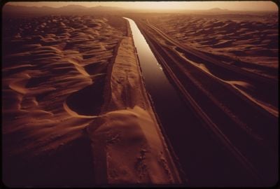
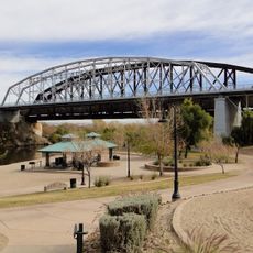
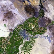
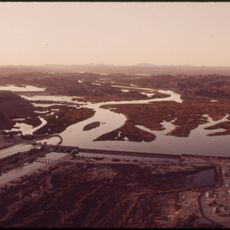
The All-American Canal is a concrete-lined waterway stretching over 80 miles through southeastern California that carries water from the Colorado River into the Imperial Valley. The channel delivers irrigation water to farmland across this dry region and was built as a major engineering project in the mid-1900s.

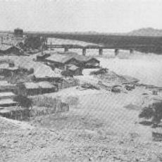
The waterway was constructed during the 1930s and completed in the early 1940s as part of a major irrigation initiative for the region. It opened the Imperial Valley to large-scale farming where the land was previously too dry to support significant agriculture.

The waterway shaped how people settled and farmed in this region, creating a shared resource that brought communities together around agriculture. You can see this influence in the way towns and villages developed along its path over the decades.

You can best explore the canal from the roads and pathways that run alongside it, which give you views of the waterway as it cuts through the landscape. The area is quite hot and dry during summer months, so visiting in cooler seasons makes for a more comfortable experience.

What makes this waterway memorable is its concrete lining, which was added to stop water from seeping away into the surrounding soil where it would be lost. Without this protective coating, a significant amount of water would drain away before reaching the farmland downstream.

Location: California

GPS coordinates: 32.87588,-114.47245

Latest update: December 14, 2025 00:37

Photos
Around this place
Yuma Territorial Prison
United States of America

Yuma Territorial Prison

21.3 km
Old Plank Road
United States of America

Old Plank Road

46 km
Desert Sun Stadium
United States of America

Desert Sun Stadium

28.2 km
Ocean To Ocean Bridge
United States of America

Ocean To Ocean Bridge

21.2 km
Yuma Crossing
United States of America

Yuma Crossing

21.2 km
Pilot Knob
United States of America

Pilot Knob

30.5 km
Yuma Quartermaster Depot State Historic Park
United States of America

Yuma Quartermaster Depot State Historic Park

22 km
Imperial Reservoir
United States of America

Imperial Reservoir

925 m
United States of America

Brock Reservoir

55.7 km
Mission Puerto de Purísima Concepción
United States of America

Mission Puerto de Purísima Concepción

21 km
Museo Sol del Niño
Mexico

Museo Sol del Niño

96.8 km
United States of America

All-American Canal Bridge

48.4 km
Mexico

Instituto de Investigaciones Culturales Museo

95 km
Brown House
United States of America

Brown House

22 km
Z Fun Factory and Waylon's Water World
United States of America

Z Fun Factory and Waylon's Water World

22.6 km
United States of America

Redondo Reservoir

24 km
St. Paul's Episcopal Church
United States of America

St. Paul's Episcopal Church

22.7 km
United States Post Office–Yuma Main
United States of America

United States Post Office–Yuma Main

21.9 km
Masonic Temple
United States of America

Masonic Temple

21.9 km
Methodist Episcopal Church
United States of America

Methodist Episcopal Church

22 km
Blaisdell Slow Sand Filter Washing Machine
United States of America

Blaisdell Slow Sand Filter Washing Machine

21.4 km
United States of America

Mexican Consulate

22.3 km
Calexico Carnegie Library
United States of America

Calexico Carnegie Library

98.2 km
Southern Pacific Railroad Passenger Coach Car-S.P. X7
United States of America

Southern Pacific Railroad Passenger Coach Car-S.P. X7

21.6 km
Ortiz House
United States of America

Ortiz House

21.9 km
Cactus Press-Plaza Paint Building
United States of America

Cactus Press-Plaza Paint Building

21.9 km
Yuma County Courthouse
United States of America

Yuma County Courthouse

21.9 km
Jerry Kent House
United States of America

Jerry Kent House

22.5 km
Show the full map
Reviews

Visited this place? Tap the stars to rate it and share your experience / photos with the community! Try now! You can cancel it anytime.

« All-American Canal - Water transport infrastructure in Imperial Valley, California » is provided by Around Us (aroundus.com). Images and texts are derived from Wikimedia project under a Creative Commons license. You are allowed to copy, distribute, and modify copies of this page, under the conditions set by the license, as long as this note is clearly visible.

Discover hidden gems everywhere you go!

From secret cafés to breathtaking viewpoints, skip the crowded tourist spots and find places that match your style. Our app makes it easy with voice search, smart filtering, route optimization, and insider tips from travelers worldwide. Download now for the complete mobile experience.

Around Us App Screenshot

A unique approach to discovering new places

Le Figaro

All the places worth exploring

France Info

A tailor-made excursion in just a few clicks

20 Minutes