Enable Location

We need your location to show you interesting places around you

Discover nearby places

Find interesting locations and hidden gems around you

Precise directions

Get accurate directions and distances to places

Your location is never shared with other users. It's only used when you tap the location button.

Log in to your account

Start exploring — it's free

Trusted by 63,035 travelers worldwide

Continue with Google
Continue with Apple
or

We will send you a code to connect

By continuing, you accept our Terms and Conditions and our Privacy Policy

Check your inbox

We've sent a pincode in your inbox. Please enter the code below.

All-American Canal Bridge
Discussion Reviews Photo
1.9k Popularity

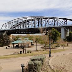
All-American Canal Bridge, Road bridge over All-American Canal in Imperial County, California, US

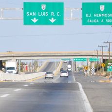
The All-American Canal Bridge is a road bridge carrying Interstate 8 across an irrigation waterway in Imperial County. The structure spans a canal that brings water to farmland in the surrounding desert region.

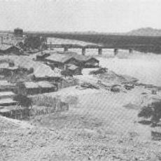
The bridge opened in 1939 as part of the original US Route 80, serving as a critical crossing between California and Arizona. In the 1960s, it was rebuilt to accommodate interstate freeway traffic and engineered to carry significantly heavier vehicle loads.

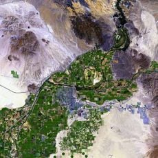
The bridge represents the connection between water management infrastructure and transportation networks that support agriculture in the Imperial Valley region.

You can drive across the bridge any time as it is part of Interstate 8, one of the main routes connecting California and Arizona. The crossing is brief and allows you to observe the irrigation system below that supports agriculture in this region.

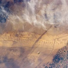
The bridge spans a canal system that irrigates 630,000 acres of farmland, transforming desert terrain into productive agricultural fields through Colorado River water.

The community of curious travelers

AroundUs brings together thousands of curated places, local tips, and hidden gems, enriched daily by 60,000 contributors worldwide.

Start exploring
Location
Official opening
1939
GPS coordinates
32.70800,-114.94900
Latest update
December 14, 2025 11:23
Around this place
Algodones Dunes
United States of America

Algodones Dunes

30.6 km
Old Plank Road
United States of America

Old Plank Road

2.5 km
Alamo Canal
United States of America

Alamo Canal

11.4 km
Desert Sun Stadium
United States of America

Desert Sun Stadium

29.7 km
Ocean To Ocean Bridge
United States of America

Ocean To Ocean Bridge

31.3 km
Yuma Crossing
United States of America

Yuma Crossing

31.3 km
Pilot Knob
United States of America

Pilot Knob

18.8 km
Yuma Quartermaster Depot State Historic Park
United States of America

Yuma Quartermaster Depot State Historic Park

30.2 km
Hermosillo
Mexico

Hermosillo

22.1 km
Brown House
United States of America

Brown House

30.8 km
St. Paul's Episcopal Church
United States of America

St. Paul's Episcopal Church

30.7 km
United States Post Office–Yuma Main
United States of America

United States Post Office–Yuma Main

31.1 km
Masonic Temple
United States of America

Masonic Temple

30.7 km
Methodist Episcopal Church
United States of America

Methodist Episcopal Church

30.8 km
Blaisdell Slow Sand Filter Washing Machine
United States of America

Blaisdell Slow Sand Filter Washing Machine

31.2 km
Southern Pacific Railroad Passenger Coach Car-S.P. X7
United States of America

Southern Pacific Railroad Passenger Coach Car-S.P. X7

30.7 km
Ortiz House
United States of America

Ortiz House

30.8 km
Cactus Press-Plaza Paint Building
United States of America

Cactus Press-Plaza Paint Building

31 km
Yuma County Courthouse
United States of America

Yuma County Courthouse

30.7 km
Jerry Kent House
United States of America

Jerry Kent House

30.5 km
Yuma City Hall
United States of America

Yuma City Hall

30.9 km
Gandolfo Theatre
United States of America

Gandolfo Theatre

30.8 km
Frank Ewing House
United States of America

Frank Ewing House

30.6 km
Balsz House
United States of America

Balsz House

30.7 km
J. Homer Smith House
United States of America

J. Homer Smith House

30.4 km
Brownstetter House
United States of America

Brownstetter House

30.3 km
Caruthers House
United States of America

Caruthers House

30.6 km
Ruth Ewing House
United States of America

Ruth Ewing House

30.6 km
Show the full map
Reviews
Share your experience

No review yet

Discussions
Start a discussion...

No discussion yet

« All-American Canal Bridge - Road bridge over All-American Canal in Imperial County, California, US » is provided by Around Us (aroundus.com). Images and texts are derived from Wikimedia project under a Creative Commons license. You are allowed to copy, distribute, and modify copies of this page, under the conditions set by the license, as long as this note is clearly visible.

Discover hidden gems everywhere you go!

From secret cafés to breathtaking viewpoints, skip the crowded tourist spots and find places that match your style. Our app makes it easy with voice search, smart filtering, route optimization, and insider tips from travelers worldwide. Download now for the complete mobile experience.

Around Us App Screenshot

A unique approach to discovering new places

Le Figaro

All the places worth exploring

France Info

A tailor-made excursion in just a few clicks

20 Minutes

Around Us
Travel Guide & Maps
Download

Send to your phone

QR Code
1

Open the camera app on your mobile.

2

Point at the QR code with your camera. A notification will appear.

3

Tap the notification to open the link.