Enable Location

We need your location to show you interesting places around you

Discover nearby places

Find interesting locations and hidden gems around you

Precise directions

Get accurate directions and distances to places

Your location is never shared with other users. It's only used when you tap the location button.

Walnut Park Farm Historic District

Log in to your account

Start exploring — it's free

Trusted by 61,983 travelers worldwide

Continue with Google
Continue with Apple
or

We will send you a code to connect

By continuing, you accept our Terms and Conditions and our Privacy Policy

Check your inbox

We've sent a pincode in your inbox. Please enter the code below.

Walnut Park Farm Historic District

Walnut Park Farm Historic District, Historic farm district near St. Joseph, Missouri.

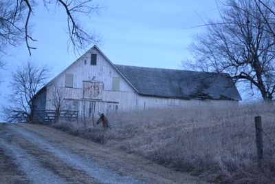
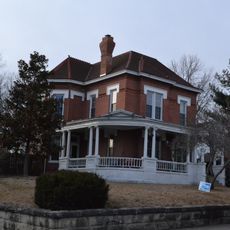
Walnut Park Farm Historic District is a rural agricultural property near St. Joseph that covers 87 acres and preserves multiple original structures from the late 1800s. The centerpiece is a large L-shaped barn with a basement and a separate stable building, accompanied by additional original structures that reveal how farming operations were conducted during this period.

The property evolved from a modest farm into a major livestock breeding operation between 1870 and 1914. During this span, most buildings were constructed according to the modern agricultural standards of the era, reflecting the growing demands of an expanding farming enterprise.

The farm's name reflects the walnut trees that once dotted the land, shaping local identity and landscape memory. The layout of buildings follows patterns typical of 19th-century agricultural settlements, where homes and working structures were positioned to support daily farming rhythms.

The site sits at the junction of highways MO 59 and MO 71, making it easy to locate and access. The buildings can be viewed from outside, and the rural setting allows you to understand the historical context without modern distractions surrounding the property.

The property contains remnants of an enclosed track and show ring where purebred horses were trained and displayed to prospective buyers. This infrastructure reveals that the operation served as a sales center for high-quality breeding stock, not just as a production farm.

The community of curious travelers

AroundUs brings together thousands of curated places, local tips, and hidden gems, enriched daily by 60,000 contributors worldwide.

Start exploring
Location
GPS coordinates
39.83222,-94.81278
Latest update
December 14, 2025 18:46
Around this place
United States of America

Krug Park

4.8 km
Terrible's St. Jo Frontier Casino
United States of America

Terrible's St. Jo Frontier Casino

7.7 km
Robidoux Row
United States of America

Robidoux Row

7.4 km
Albrecht-Kemper Museum
United States of America

Albrecht-Kemper Museum

6.3 km
Hall Street Historic District
United States of America

Hall Street Historic District

7.4 km
St. Joseph City Hall
United States of America

St. Joseph City Hall

7.6 km
Cathedral Hill Historic District
United States of America

Cathedral Hill Historic District

7.2 km
St. Joseph Public Library
United States of America

St. Joseph Public Library

7.9 km
Century Apartments
United States of America

Century Apartments

7 km
Krug Park Place Historic District
United States of America

Krug Park Place Historic District

5.4 km
Miller-Porter-Lacy House
United States of America

Miller-Porter-Lacy House

6.3 km
McIntyre-Burri House
United States of America

McIntyre-Burri House

6.4 km
Christian Sachau Saloon
United States of America

Christian Sachau Saloon

7.1 km
Buchanan County Infirmary
United States of America

Buchanan County Infirmary

1.5 km
Dr. Jacob Geiger House-Maud Wyeth Painter House
United States of America

Dr. Jacob Geiger House-Maud Wyeth Painter House

6.3 km
Isaac Miller House
United States of America

Isaac Miller House

4 km
Robidoux Hill Historic District
United States of America

Robidoux Hill Historic District

7.6 km
Kemper Addition Historic District
United States of America

Kemper Addition Historic District

7 km
Virginia Flats
United States of America

Virginia Flats

7.5 km
Harris Addition Historic District
United States of America

Harris Addition Historic District

7.5 km
City Hose Company No. 9
United States of America

City Hose Company No. 9

6.5 km
Ryan Block
United States of America

Ryan Block

7.5 km
Wyeth Flats
United States of America

Wyeth Flats

7.6 km
Lawler Motor Company Building
United States of America

Lawler Motor Company Building

7.2 km
Maple Grove
United States of America

Maple Grove

6 km
Kelley and Browne Flats
United States of America

Kelley and Browne Flats

7.4 km
John Sublett Jr. and Caroline Ashton Logan House
United States of America

John Sublett Jr. and Caroline Ashton Logan House

5.5 km
Dewey Avenue-West Rosine Historic District
United States of America

Dewey Avenue-West Rosine Historic District

7.3 km
Show the full map
« Walnut Park Farm Historic District - Historic farm district near St. Joseph, Missouri » is provided by Around Us (aroundus.com). Images and texts are derived from Wikimedia project under a Creative Commons license. You are allowed to copy, distribute, and modify copies of this page, under the conditions set by the license, as long as this note is clearly visible.

Discover hidden gems everywhere you go!

From secret cafés to breathtaking viewpoints, skip the crowded tourist spots and find places that match your style. Our app makes it easy with voice search, smart filtering, route optimization, and insider tips from travelers worldwide. Download now for the complete mobile experience.

Around Us App Screenshot

A unique approach to discovering new places

Le Figaro

All the places worth exploring

France Info

A tailor-made excursion in just a few clicks

20 Minutes

Around Us
Travel Guide & Maps
Download

Send to your phone

QR Code
1

Open the camera app on your mobile.

2

Point at the QR code with your camera. A notification will appear.

3

Tap the notification to open the link.