Enable Location

We need your location to show you interesting places around you

Discover nearby places

Find interesting locations and hidden gems around you

Precise directions

Get accurate directions and distances to places

Your location is never shared with other users. It's only used when you tap the location button.

Log in to your account

Start exploring — it's free

Trusted by 61,382 travelers worldwide

Continue with Google
Continue with Apple
or

We will send you a code to connect

By continuing, you accept our Terms and Conditions and our Privacy Policy

Check your inbox

We've sent a pincode in your inbox. Please enter the code below.

Freedom Riders National Monument

Freedom Riders National Monument, Civil rights memorial in Anniston, Alabama, United States.

Description

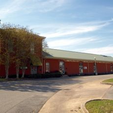
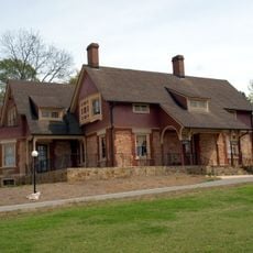
The Freedom Riders National Monument is a civil rights memorial in Anniston, Alabama, comprising two main locations: a former Greyhound bus station downtown and the site where a bus was attacked in 1961. Both places are connected by their central role in the pivotal events of the American civil rights movement.

History

The monument was established in 2017 when President Barack Obama designated these sites to preserve the events of May 1961. During that time, civil rights activists traveled south to challenge segregation in interstate bus travel.

Culture

The monument documents how integrated groups of black and white activists traveled together to challenge racial segregation in transportation. Today, visitors can stand at these locations and grasp the personal courage it took to face violent opposition for equality.

Practical

The visit requires minimal preparation, as both sites are within walking distance and feature informational panels on location. The visitor center at Anniston City Hall offers additional materials and guidance for those wanting more context.

Did you know?

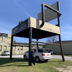
A wall adjacent to the former bus station features murals and panels depicting the attacks of May 1961. These visual representations help visitors understand the intensity of the violence that occurred there.

Location
Operator
National Park Service
GPS coordinates
33.63454,-85.90797
Latest update
December 8, 2025 13:42

AroundUs brings together thousands of curated places, local tips, and hidden gems, enriched daily by 60,000 contributors worldwide. Discover all places nearby (Calhoun County).

Around this place
Coldwater Covered Bridge
United States of America

Coldwater Covered Bridge

9 km
Parker Memorial Baptist Church
United States of America

Parker Memorial Baptist Church

8.1 km
St. Michael and All Angels Episcopal Church
United States of America

St. Michael and All Angels Episcopal Church

7 km
Samuel Noble Monument
United States of America

Samuel Noble Monument

8 km
Grace Episcopal Church
United States of America

Grace Episcopal Church

8.1 km
Temple Beth-El
United States of America

Temple Beth-El

8.2 km
Saint Paul's Methodist Episcopal Church
United States of America

Saint Paul's Methodist Episcopal Church

8.3 km
Mount Zion Baptist Church
United States of America

Mount Zion Baptist Church

7.1 km
Calhoun County Courthouse
United States of America

Calhoun County Courthouse

7.6 km
Davis C. Cooper House
United States of America

Davis C. Cooper House

7.1 km
Dudley Snow House
United States of America

Dudley Snow House

10.6 km
Union Depot and Freight House
United States of America

Union Depot and Freight House

7.5 km
Kilby House
United States of America

Kilby House

8.6 km
Anniston Manufacturing Company
United States of America

Anniston Manufacturing Company

7.3 km
Hillside Cemetery
United States of America

Hillside Cemetery

8.7 km
Glen Addie Volunteer Hose Company Fire Hall
United States of America

Glen Addie Volunteer Hose Company Fire Hall

6.8 km
Richard P. Huger House
United States of America

Richard P. Huger House

8.3 km
McKleroy-Wilson-Kirby House
United States of America

McKleroy-Wilson-Kirby House

8.2 km
Crowan Cottage
United States of America

Crowan Cottage

8.7 km
Bank of Anniston
United States of America

Bank of Anniston

7.7 km
World’s Largest Chair
United States of America

World’s Largest Chair

7.5 km
United States of America

Carmike Plaza 6

9.8 km
United States of America

Cameo Theatre

7.7 km
United States of America

Calhoun Theater

7.8 km
United States of America

Thomas Newbern Museum

8.6 km
United States of America

Cone Reservoir

8.7 km
United States of America

Anniston Country Club

8.7 km
United States of America

Greyhound Mural

7.6 km
Show the full map
« Freedom Riders National Monument - Civil rights memorial in Anniston, Alabama, United States » is provided by Around Us (aroundus.com). Images and texts are derived from Wikimedia project under a Creative Commons license. You are allowed to copy, distribute, and modify copies of this page, under the conditions set by the license, as long as this note is clearly visible.

Discover hidden gems everywhere you go!

From secret cafés to breathtaking viewpoints, skip the crowded tourist spots and find places that match your style. Our app makes it easy with voice search, smart filtering, route optimization, and insider tips from travelers worldwide. Download now for the complete mobile experience.

Around Us App Screenshot

A unique approach to discovering new places

Le Figaro

All the places worth exploring

France Info

A tailor-made excursion in just a few clicks

20 Minutes

Around Us
Travel Guide & Maps
Download

Send to your phone

QR Code
1

Open the camera app on your mobile.

2

Point at the QR code with your camera. A notification will appear.

3

Tap the notification to open the link.