Enable Location

We need your location to show you interesting places around you

Discover nearby places

Find interesting locations and hidden gems around you

Precise directions

Get accurate directions and distances to places

Your location is never shared with other users. It's only used when you tap the location button.

Coldwater Covered Bridge

Log in to your account

Start exploring — it's free

Trusted by 65,817 travelers worldwide

Continue with Google
Continue with Apple
or

We will send you a code to connect

By continuing, you accept our Terms and Conditions and our Privacy Policy

Check your inbox

We've sent a pincode in your inbox. Please enter the code below.

Discussion Reviews 1 Photos
3.2k Popularity

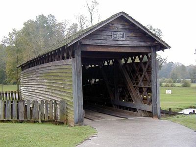
Coldwater Covered Bridge, Covered bridge in Oxford, Calhoun County, US.

The Coldwater Covered Bridge is a wooden covered bridge in Calhoun County, Michigan, crossing a creek near the city of Coldwater. It is built with timber beams and a protective roof that shelters the load-bearing structure from the weather.

The bridge was built in 1850, making it one of the oldest surviving wooden bridges in Michigan. After a fire in 1920 damaged it, repairs were made, and it was later added to the National Register of Historic Places.

The bridge shows how craftsmen in the 1800s crossed local waterways by combining a timber frame with a protective cover. Visitors can still see the original wooden beams and the joinery methods that were common at the time.

The bridge sits within a park and can be reached on foot, with walking paths nearby. It is open year-round, though spring and fall tend to offer the most comfortable conditions for a visit.

The bridge combines two different timber framing systems in a single structure, which is unusual for a bridge of its era. This makes it a useful reference for researchers studying how wooden bridge construction evolved in the region.

The community of curious travelers

AroundUs brings together thousands of curated places, local tips, and hidden gems, enriched daily by 60,000 contributors worldwide.

Start exploring
Location
Inception
1850
Made from material
wood
GPS coordinates
33.60761,-85.81641
Latest update
March 3, 2026 13:56
Around this place
Cheaha Mountain
United States of America

Cheaha Mountain

13.6 km
Cheaha State Park
United States of America

Cheaha State Park

14.5 km
Bunker Tower
United States of America

Bunker Tower

13.6 km
Anniston Museum of Natural History
United States of America

Anniston Museum of Natural History

9.9 km
Parker Memorial Baptist Church
United States of America

Parker Memorial Baptist Church

5.9 km
St. Michael and All Angels Episcopal Church
United States of America

St. Michael and All Angels Episcopal Church

7.1 km
Samuel Noble Monument
United States of America

Samuel Noble Monument

5.7 km
Grace Episcopal Church
United States of America

Grace Episcopal Church

5.6 km
Temple Beth-El
United States of America

Temple Beth-El

6 km
John Morgan House
United States of America

John Morgan House

21.8 km
Saint Paul's Methodist Episcopal Church
United States of America

Saint Paul's Methodist Episcopal Church

6 km
Mount Zion Baptist Church
United States of America

Mount Zion Baptist Church

4.6 km
Calhoun County Courthouse
United States of America

Calhoun County Courthouse

5.8 km
Ross Creek Bridge
United States of America

Ross Creek Bridge

21.1 km
Ten Oaks
United States of America

Ten Oaks

23 km
Aderholdt's Mill
United States of America

Aderholdt's Mill

19.8 km
Davis C. Cooper House
United States of America

Davis C. Cooper House

1.9 km
Union Depot and Freight House
United States of America

Union Depot and Freight House

6.1 km
Dudley Snow House
United States of America

Dudley Snow House

2.7 km
First Presbyterian Church
United States of America

First Presbyterian Church

23.2 km
Kilby House
United States of America

Kilby House

5.8 km
Walt Farr Native American Relic Museum
United States of America

Walt Farr Native American Relic Museum

14.5 km
Richard P. Huger House
United States of America

Richard P. Huger House

6.9 km
McKleroy-Wilson-Kirby House
United States of America

McKleroy-Wilson-Kirby House

6.5 km
Crowan Cottage
United States of America

Crowan Cottage

6.1 km
Bank of Anniston
United States of America

Bank of Anniston

5.6 km
Cleburne County Courthouse
United States of America

Cleburne County Courthouse

21.7 km
Berman Museum
United States of America

Berman Museum

10 km
Show the full map
Reviews
Share your experience

No review yet

Discussions
Start a discussion...

No discussion yet

« Coldwater Covered Bridge - Covered bridge in Oxford, Calhoun County, US » is provided by Around Us (aroundus.com). Images and texts are derived from Wikimedia project under a Creative Commons license. You are allowed to copy, distribute, and modify copies of this page, under the conditions set by the license, as long as this note is clearly visible.

Discover hidden gems everywhere you go!

From secret cafés to breathtaking viewpoints, skip the crowded tourist spots and find places that match your style. Our app makes it easy with voice search, smart filtering, route optimization, and insider tips from travelers worldwide. Download now for the complete mobile experience.

Around Us App Screenshot

A unique approach to discovering new places

Le Figaro

All the places worth exploring

France Info

A tailor-made excursion in just a few clicks

20 Minutes

Around Us
Travel Guide & Maps
Download

Send to your phone

QR Code
1

Open the camera app on your mobile.

2

Point at the QR code with your camera. A notification will appear.

3

Tap the notification to open the link.