Enable Location

We need your location to show you interesting places around you

Discover nearby places

Find interesting locations and hidden gems around you

Precise directions

Get accurate directions and distances to places

Your location is never shared with other users. It's only used when you tap the location button.

Cheaha State Park

Log in to your account

Start exploring — it's free

Trusted by 63,294 travelers worldwide

Continue with Google
Continue with Apple
or

We will send you a code to connect

By continuing, you accept our Terms and Conditions and our Privacy Policy

Check your inbox

We've sent a pincode in your inbox. Please enter the code below.

Cheaha State Park
Discussion Reviews 1 Photos
12.9k Popularity

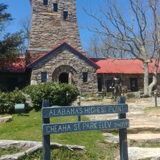
Cheaha State Park, National park in Talladega County, United States

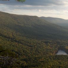
The park covers 2,799 acres of mountain terrain, forests, and streams at 2,407 feet (733 m) elevation within Talladega National Forest. The landscape features varied ecosystems and offers hikers numerous paths through the wilderness.

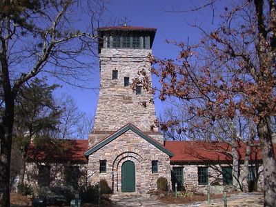
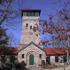
The park opened in 1933, and the Civilian Conservation Corps built stone structures, pavilions, and the observation tower between 1933 and 1939. This work shaped the park's present character and represents New Deal conservation efforts.

The name comes from the Muskogee Creek language and means 'high place', reflecting its role as Alabama's highest point. Visitors can feel this connection to nature and Creek heritage while exploring the grounds.

The grounds offer 73 modern campsites, a 30-room lodge, chalets, cabins, and several hiking trails, including a connection to the Appalachian Trail. Visitors should prepare for changing weather and wear proper footwear for exploring trails.

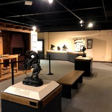
A P-38 Lightning fighter plane crashed into Bald Rock in 1944, and its recovered machine gun became part of the park museum in 2023. This surprising wartime story offers an unexpected glimpse into local history.

The community of curious travelers

AroundUs brings together thousands of curated places, local tips, and hidden gems, enriched daily by 60,000 contributors worldwide.

Start exploring
Location
Operator
Alabama Department of Conservation and Natural Resources, State Parks Division
GPS coordinates
33.47759,-85.81154
Latest update
December 7, 2025 20:42
Around this place
Cheaha Mountain
United States of America

Cheaha Mountain

930 m
Coldwater Covered Bridge
United States of America

Coldwater Covered Bridge

14.5 km
Bunker Tower
United States of America

Bunker Tower

917 m
Anniston Museum of Natural History
United States of America

Anniston Museum of Natural History

24.4 km
J. L. M. Curry House
United States of America

J. L. M. Curry House

21.8 km
Waldo Covered Bridge
United States of America

Waldo Covered Bridge

23 km
Parker Memorial Baptist Church
United States of America

Parker Memorial Baptist Church

20.4 km
St. Michael and All Angels Episcopal Church
United States of America

St. Michael and All Angels Episcopal Church

21.3 km
Samuel Noble Monument
United States of America

Samuel Noble Monument

20.1 km
Grace Episcopal Church
United States of America

Grace Episcopal Church

20.1 km
Temple Beth-El
United States of America

Temple Beth-El

20.5 km
Saint Paul's Methodist Episcopal Church
United States of America

Saint Paul's Methodist Episcopal Church

20.5 km
Mount Zion Baptist Church
United States of America

Mount Zion Baptist Church

18.9 km
Calhoun County Courthouse
United States of America

Calhoun County Courthouse

20.2 km
Ross Creek Bridge
United States of America

Ross Creek Bridge

25.1 km
Davis C. Cooper House
United States of America

Davis C. Cooper House

15.6 km
Clay County Courthouse
United States of America

Clay County Courthouse

22.8 km
Dudley Snow House
United States of America

Dudley Snow House

11.8 km
Union Depot and Freight House
United States of America

Union Depot and Freight House

20.5 km
Kilby House
United States of America

Kilby House

20.3 km
Idlewild
United States of America

Idlewild

22.1 km
Walt Farr Native American Relic Museum
United States of America

Walt Farr Native American Relic Museum

306 m
Richard P. Huger House
United States of America

Richard P. Huger House

21.4 km
McKleroy-Wilson-Kirby House
United States of America

McKleroy-Wilson-Kirby House

20.9 km
Crowan Cottage
United States of America

Crowan Cottage

20.6 km
Bank of Anniston
United States of America

Bank of Anniston

20 km
Berman Museum
United States of America

Berman Museum

24.5 km
World’s Largest Chair
United States of America

World’s Largest Chair

19.6 km
Show the full map
Reviews
Share your experience

No review yet

Discussions
Start a discussion...

No discussion yet

« Cheaha State Park - National park in Talladega County, United States » is provided by Around Us (aroundus.com). Images and texts are derived from Wikimedia project under a Creative Commons license. You are allowed to copy, distribute, and modify copies of this page, under the conditions set by the license, as long as this note is clearly visible.

Discover hidden gems everywhere you go!

From secret cafés to breathtaking viewpoints, skip the crowded tourist spots and find places that match your style. Our app makes it easy with voice search, smart filtering, route optimization, and insider tips from travelers worldwide. Download now for the complete mobile experience.

Around Us App Screenshot

A unique approach to discovering new places

Le Figaro

All the places worth exploring

France Info

A tailor-made excursion in just a few clicks

20 Minutes

Around Us
Travel Guide & Maps
Download

Send to your phone

QR Code
1

Open the camera app on your mobile.

2

Point at the QR code with your camera. A notification will appear.

3

Tap the notification to open the link.