Chest opened
+${chestReward.xp} XP
Explorer
NOUVEAU ×${chestReward.collectible.quantity}
tapez pour fermer
Chest locked

Open chests in the app

Around Us is built for your phone — chests unlock when you walk, explore and capture nearby places.

Enable Location

We need your location to show you interesting places around you

Discover nearby places

Find interesting locations and hidden gems around you

Precise directions

Get accurate directions and distances to places

Your location is never shared with other users. It's only used when you tap the location button.

Log in to your account

Start exploring — it's free

Trusted by 72,878 travelers worldwide

Continue with Google
Continue with Apple
or

We will send you a code to connect

By continuing, you accept our Terms and Conditions and our Privacy Policy

Check your inbox

We've sent a pincode in your inbox. Please enter the code below.

Discussion Reviews Photo
1.2k Popularity

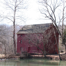
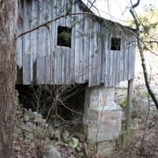
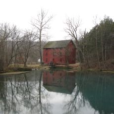
Greer Mill, Historic mill in Oregon County, Missouri.

Greer Mill is a three-story building situated on a hilltop near Missouri Highway 19 in Oregon County. The structure features a turbine waterwheel system and vintage machinery with pulleys and cables that powered the grain processing operations.

Samuel W. Greer built the original mill in 1860, but it was destroyed by bushwhackers during the Civil War. The mill was reconstructed and relocated to its current hilltop position in 1899.

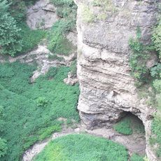
For generations, local farmers brought their grain to this location, making it a hub for agricultural communities in the region. The building stands as a reminder of how mills shaped daily routines and trade in rural areas.

The building is typically closed to regular visitors, as it is maintained by the Friends of the Eleven Point River organization. Those interested in viewing the interior should reach out to local organizations to learn about special opening dates and guided tours.

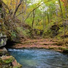
Samuel Greer trained oxen to haul logs and grain up the hillside route on their own without human guidance. This ingenuity reflects how early settlers found creative ways to solve the challenge of moving goods in rough terrain.

The community of curious travelers

AroundUs brings together thousands of curated places, local tips, and hidden gems, enriched daily by 60,000 contributors worldwide.

Start exploring
Location
GPS coordinates
36.78639,-91.34250
Latest update
December 14, 2025 18:45
Around this place
Mammoth Spring
United States of America

Mammoth Spring

36.5 km
Grand Gulf State Park
United States of America

Grand Gulf State Park

38.1 km
Greer Spring
United States of America

Greer Spring

447 m
Mammoth Spring State Park
United States of America

Mammoth Spring State Park

36.7 km
Mammoth Spring State Park
United States of America

Mammoth Spring State Park

36.7 km
Eleven Point State Park
United States of America

Eleven Point State Park

24.1 km
Current River Cavern
United States of America

Current River Cavern

34.7 km
Alley Spring Roller Mill
United States of America

Alley Spring Roller Mill

41.9 km
AR 289 Bridge Over English Creek
United States of America

AR 289 Bridge Over English Creek

42.8 km
United States of America

Mount Zion Lodge Masonic Temple

45.8 km
Courthouse Square Historic District
United States of America

Courthouse Square Historic District

45.9 km
Walter Klepzig Mill and Farm
United States of America

Walter Klepzig Mill and Farm

39.8 km
Hillyard Cabin
United States of America

Hillyard Cabin

43.5 km
Spring River Bridge
United States of America

Spring River Bridge

38.1 km
Ripley County Jail, Sheriff's Office and Sheriff's Residence
United States of America

Ripley County Jail, Sheriff's Office and Sheriff's Residence

49.7 km
Big Spring Historic District
United States of America

Big Spring Historic District

36 km
Randolph Columbus Barrett House
United States of America

Randolph Columbus Barrett House

49.8 km
Rice-Upshaw House
United States of America

Rice-Upshaw House

45.7 km
Ripley County Courthouse
United States of America

Ripley County Courthouse

49.7 km
Saint Andrew's Episcopal Church
United States of America

Saint Andrew's Episcopal Church

36.6 km
Fred Carter House
United States of America

Fred Carter House

53.5 km
Reed Log House
United States of America

Reed Log House

43.6 km
United States of America

Yadkin Church

46.1 km
Looney-French House
United States of America

Looney-French House

47.6 km
T.H. Morris House
United States of America

T.H. Morris House

37.1 km
Alley Spring
United States of America

Alley Spring

41.9 km
Lightning Bowl
United States of America

Lightning Bowl

49.1 km
Carter County Courthouse
United States of America

Carter County Courthouse

37.3 km
Show the full map
Reviews
Share your experience

No review yet

Discussions
Start a discussion...

No discussion yet

« Greer Mill - Historic mill in Oregon County, Missouri » is provided by Around Us (aroundus.com). Images and texts are derived from Wikimedia project under a Creative Commons license. You are allowed to copy, distribute, and modify copies of this page, under the conditions set by the license, as long as this note is clearly visible.

Discover hidden gems everywhere you go!

From secret cafés to breathtaking viewpoints, skip the crowded tourist spots and find places that match your style. Our app makes it easy with voice search, smart filtering, route optimization, and insider tips from travelers worldwide. Download now for the complete mobile experience.

Around Us App Screenshot

A unique approach to discovering new places

Le Figaro

All the places worth exploring

France Info

A tailor-made excursion in just a few clicks

20 Minutes

Around Us
Travel Guide & Maps
Download

Send to your phone

QR Code
1

Open the camera app on your mobile.

2

Point at the QR code with your camera. A notification will appear.

3

Tap the notification to open the link.