Enable Location

We need your location to show you interesting places around you

Discover nearby places

Find interesting locations and hidden gems around you

Precise directions

Get accurate directions and distances to places

Your location is never shared with other users. It's only used when you tap the location button.

Morgan Hill State Forest

Log in to your account

Start exploring — it's free

Trusted by 61,559 travelers worldwide

Continue with Google
Continue with Apple
or

We will send you a code to connect

By continuing, you accept our Terms and Conditions and our Privacy Policy

Check your inbox

We've sent a pincode in your inbox. Please enter the code below.

Morgan Hill State Forest

Morgan Hill State Forest, State forest in Onondaga and Cortland Counties, New York, US.

Description

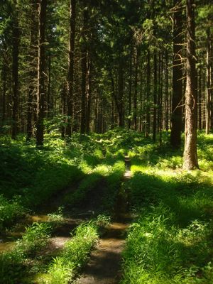
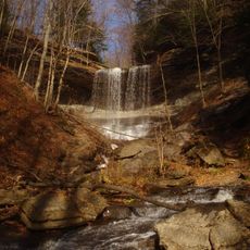
Morgan Hill State Forest is a state forest in Onondaga and Cortland Counties that spans thousands of acres across rolling terrain with streams, wetlands, and upland woods. The area features a network of marked trails passing through different forest types and connecting to the broader North Country trail system.

History

The land once served as hunting grounds for the Iroquois and was later converted to farmland following the Revolutionary War. In the 1930s, reforestation efforts transformed it into a state forest.

Culture

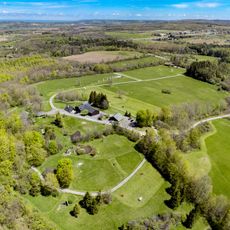
The forest shows signs of human care across its trails and clearings, where visitors notice the blend of natural recovery and managed woodland. Walking through the area reveals how local outdoor groups use the trails for seasonal activities and nature study.

Practical

The forest is accessible year-round along public roads and trails of varying difficulty levels. Overnight stays are possible in designated camping areas, though advance arrangements and permits may be required during certain seasons.

Did you know?

During the 1930s, workers from the Civilian Conservation Corps planted millions of conifer seedlings across this land, establishing the foundation for the forest visible today. These historical plantings continue to shape the forest's composition and appearance.

Location
GPS coordinates
42.77500,-76.00400
Latest update
December 14, 2025 18:20

AroundUs brings together thousands of curated places, local tips, and hidden gems, enriched daily by 60,000 contributors worldwide. Discover all places nearby (New York).

Around this place
Labrador Hollow Unique Area
United States of America

Labrador Hollow Unique Area

3.6 km
Lorenzo State Historic Site
United States of America

Lorenzo State Historic Site

20 km
Stone Quarry Hill Art Park
United States of America

Stone Quarry Hill Art Park

20.6 km
Old Homer Village Historic District
United States of America

Old Homer Village Historic District

21.1 km
Notleymere
United States of America

Notleymere

22.4 km
Delphi Baptist Church
United States of America

Delphi Baptist Church

13.6 km
Cortland County Poor Farm
United States of America

Cortland County Poor Farm

19.8 km
Cortland County Courthouse
United States of America

Cortland County Courthouse

24.2 km
Seventh Day Baptist Church
United States of America

Seventh Day Baptist Church

9.8 km
South Otselic Historic District
United States of America

South Otselic Historic District

23.2 km
Cortland Free Library
United States of America

Cortland Free Library

24.1 km
Drover's Tavern
United States of America

Drover's Tavern

22.6 km
Hatheway Homestead
United States of America

Hatheway Homestead

19.8 km
Presbyterian Church of McGraw
United States of America

Presbyterian Church of McGraw

21.3 km
Church of the Good Shepherd
United States of America

Church of the Good Shepherd

22.9 km
William J. Greenman House
United States of America

William J. Greenman House

23.7 km
Taylor Center Methodist Episcopal Church and Taylor District No. 3 School
United States of America

Taylor Center Methodist Episcopal Church and Taylor District No. 3 School

18.8 km
Cazenovia Village Historic District
United States of America

Cazenovia Village Historic District

20.9 km
Water, Wall, and Pine Streets Lenticular Truss Bridges
United States of America

Water, Wall, and Pine Streets Lenticular Truss Bridges

20.8 km
First Presbyterian Church
United States of America

First Presbyterian Church

12.5 km
Fabius Village Historic District
United States of America

Fabius Village Historic District

6.8 km
Union Valley Congregational Church
United States of America

Union Valley Congregational Church

18.6 km
Pompey Centre District No. 10 Schoolhouse
United States of America

Pompey Centre District No. 10 Schoolhouse

17.1 km
Albany Street Historic District
United States of America

Albany Street Historic District

21.1 km
Delphi Falls
United States of America

Delphi Falls

13.1 km
Annas Farmhouse
United States of America

Annas Farmhouse

23.6 km
Oran District No. 22 Schoolhouse
United States of America

Oran District No. 22 Schoolhouse

23.4 km
Little York Pavilion
United States of America

Little York Pavilion

14.2 km
Show the full map
« Morgan Hill State Forest - State forest in Onondaga and Cortland Counties, New York, US » is provided by Around Us (aroundus.com). Images and texts are derived from Wikimedia project under a Creative Commons license. You are allowed to copy, distribute, and modify copies of this page, under the conditions set by the license, as long as this note is clearly visible.

Discover hidden gems everywhere you go!

From secret cafés to breathtaking viewpoints, skip the crowded tourist spots and find places that match your style. Our app makes it easy with voice search, smart filtering, route optimization, and insider tips from travelers worldwide. Download now for the complete mobile experience.

Around Us App Screenshot

A unique approach to discovering new places

Le Figaro

All the places worth exploring

France Info

A tailor-made excursion in just a few clicks

20 Minutes

Around Us
Travel Guide & Maps
Download

Send to your phone

QR Code
1

Open the camera app on your mobile.

2

Point at the QR code with your camera. A notification will appear.

3

Tap the notification to open the link.