Enable Location

We need your location to show you interesting places around you

Discover nearby places

Find interesting locations and hidden gems around you

Precise directions

Get accurate directions and distances to places

Your location is never shared with other users. It's only used when you tap the location button.

Log in to your account

Start exploring — it's free

Trusted by 63,775 travelers worldwide

Continue with Google
Continue with Apple
or

We will send you a code to connect

By continuing, you accept our Terms and Conditions and our Privacy Policy

Check your inbox

We've sent a pincode in your inbox. Please enter the code below.

Norwood Reservoir
Discussion Reviews Photo
1.4k Popularity

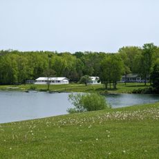
Norwood Reservoir, body of water

Norwood Reservoir is a man-made lake near the town of Norwood created by damming the Raquette River, spanning several hundred acres with shallow waters. The lake contains smallmouth bass, northern pike, rock bass, yellow perch, and walleye, and features a carry-down boat launch for public access along Riverside Road.

Small dams were built starting in the late 1920s to create this reservoir along the Raquette River, originally designed to generate electricity for nearby towns and industries. Over the decades it has transformed into a popular fishing and recreation destination while maintaining its role in water storage and flood control.

The reservoir serves as a gathering place where locals and visitors practice traditional outdoor activities like fishing and boating that connect people to the water. The quiet setting reflects the rural character of the region, where people have long maintained a relationship with nature and waterways as part of everyday life.

A carry-down boat launch on Riverside Road provides easy water access for small boats, canoes, and kayaks throughout the year. The area is most active during warmer months when fishing, boating, and shoreline walking are at their best.

The reservoir contains only one island in its otherwise open waters, a rare feature among lakes in the region. This isolated island provides a resting spot for migratory birds and makes the lake an interesting destination for wildlife observers.

The community of curious travelers

AroundUs brings together thousands of curated places, local tips, and hidden gems, enriched daily by 60,000 contributors worldwide.

Start exploring
GPS coordinates
44.65839,-74.99075
Latest update
February 9, 2026 08:18
Around this place
Upper Canada Village
Canada

Upper Canada Village

32.7 km
Upper Canada Village
Canada

Upper Canada Village

32.6 km
United States of America

Eisenhower Lock

37.4 km
Sunday Rock
United States of America

Sunday Rock

20 km
Raymondville Parabolic Bridge
United States of America

Raymondville Parabolic Bridge

20.2 km
Richardson Hall, St. Lawrence University
United States of America

Richardson Hall, St. Lawrence University

15.5 km
Buck's Bridge Community Church
United States of America

Buck's Bridge Community Church

14.3 km
United States Post Office (Canton, New York)
United States of America

United States Post Office (Canton, New York)

15.8 km
Market Street Historic District
United States of America

Market Street Historic District

1.4 km
Dr. Buck–Stevens House
United States of America

Dr. Buck–Stevens House

23.8 km
Waddington Historic District
United States of America

Waddington Historic District

28.4 km
United States of America

Trinity Episcopal Chapel

16.6 km
Hepburn Library
United States of America

Hepburn Library

16 km
Herring-Cole Hall, St. Lawrence University
United States of America

Herring-Cole Hall, St. Lawrence University

15.6 km
Village Park Historic District
United States of America

Village Park Historic District

15.7 km
Clarkson Office Building
United States of America

Clarkson Office Building

1.1 km
Jonathan Wallace House
United States of America

Jonathan Wallace House

1.5 km
Clarkson-Knowles Cottage
United States of America

Clarkson-Knowles Cottage

1.3 km
Gardner Cox House
United States of America

Gardner Cox House

5.4 km
Hopkinton Green Historic District
United States of America

Hopkinton Green Historic District

23 km
St. Lawrence University-Old Campus Historic District
United States of America

St. Lawrence University-Old Campus Historic District

15.7 km
Upper Canada Migratory Bird Sanctuary
Canada

Upper Canada Migratory Bird Sanctuary

32.8 km
North Country Children's Museum
United States of America

North Country Children's Museum

1.3 km
Saint Lawrence Power and Equipment Museum
United States of America

Saint Lawrence Power and Equipment Museum

13.9 km
Battle of Crysler's Farm National Historic Site
Canada

Battle of Crysler's Farm National Historic Site

32.2 km
Lisbon Beach
United States of America

Lisbon Beach

32.5 km
Waddington Beach
United States of America

Waddington Beach

29.6 km
Iroquois Lock
Canada

Iroquois Lock

31.9 km
Show the full map
Reviews
Share your experience

No review yet

Discussions
Start a discussion...

No discussion yet

« Norwood Reservoir - body of water » is provided by Around Us (aroundus.com). Images and texts are derived from Wikimedia project under a Creative Commons license. You are allowed to copy, distribute, and modify copies of this page, under the conditions set by the license, as long as this note is clearly visible.

Discover hidden gems everywhere you go!

From secret cafés to breathtaking viewpoints, skip the crowded tourist spots and find places that match your style. Our app makes it easy with voice search, smart filtering, route optimization, and insider tips from travelers worldwide. Download now for the complete mobile experience.

Around Us App Screenshot

A unique approach to discovering new places

Le Figaro

All the places worth exploring

France Info

A tailor-made excursion in just a few clicks

20 Minutes

Around Us
Travel Guide & Maps
Download

Send to your phone

QR Code
1

Open the camera app on your mobile.

2

Point at the QR code with your camera. A notification will appear.

3

Tap the notification to open the link.