Paita Province, Coastal province in northwestern Piura Region, Peru
Paita Province is a coastal region in northwestern Piura that spans seven districts along the Pacific Ocean. The territory encompasses a variety of landscapes and communities, with the port city of Paita serving as the main settlement and economic center.
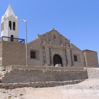
Established in 1861, the province developed around the city of Paita, which had earlier served as a Spanish administrative hub in northwestern Peru from 1578 to 1588. The region carries layers of colonial history that shaped its economic and social foundations.
Local communities gather in September for processions and ceremonies honoring Nuestra Señora de las Mercedes, a tradition that shapes the spiritual life of the region. These celebrations bring together people from surrounding areas and reflect the importance of this devotion in daily life.
The province is easily accessible from the coast and visitors can move between the various districts using local transportation. Be prepared for changing weather conditions throughout the year, as coastal areas experience seasonal variations that affect travel and outdoor activities.
The province sits directly on the Sea of Grau, giving fishing communities direct access to rich marine resources that have sustained livelihoods for generations. This connection to the sea remains central to how people here make their living and understand their place in the world.
The community of curious travelers
AroundUs brings together thousands of curated places, local tips, and hidden gems, enriched daily by 60,000 contributors worldwide.