Talara Province, Administrative province on the Pacific coast, Piura, Peru.
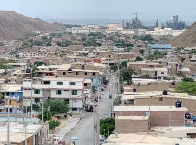
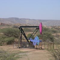
Talara Province is a coastal administrative territory in northwestern Peru divided into six districts. The region contains beaches, mountain terrain, and significant oil reserves that shape its economic structure and landscape.
The province was established in 1956 and gained strategic importance during World War II because of its oil resources. These reserves have driven regional development and influenced the territory's economic path ever since.
The province reflects a blend of maritime traditions and petroleum industry heritage that shapes daily life across its communities. Local festivals and gatherings celebrate this mixed identity, bringing together people from different districts to share regional customs.
The province is accessible via Cap FAP Víctor Montes Arias Airport and highway connections that link to neighboring regions. Visiting during drier months makes exploring beaches and inland areas more comfortable.
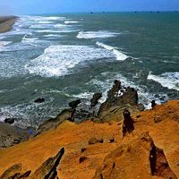
Punta Pariñas in the La Brea District marks the westernmost point of mainland South America and contains natural fossil deposits from ancient times. This geographic and paleontological significance attracts visitors interested in geology and Earth history.
Location: Piura Department
Capital city: Talara
Shares border with: Paita Province, Sullana Province, Contralmirante Villar Province
Address: Talara, Peru
GPS coordinates: -4.57972,-81.27194
Latest update: December 7, 2025 10:02
Tumbes Mangals National Sanctuary
170.1 km
Podocarpus National Park
254.3 km
Arenillas Ecological Reserve
170.3 km
Yacurí National Park
212 km
Basilica of El Cisne
220.4 km
Bernal Municipal Stadium
113.3 km
Narihualá
102.7 km
Poechos Reservoir
85.8 km
Estadio Miguel Grau
99.6 km
Tumbes National Reserve
131.9 km
Illescas Reserved Zone
156.5 km
Cathedral of Loja-Parroquia El Sagrario
238.9 km
Playa Varadero
233.1 km
Casa Museo Gran Almirante Grau
99.2 km
Catedral Emperatriz de Santa Elena
265.9 km
Puente Bolognesi
99.6 km
Iglesia San Martín de Tours de Sechura
119.8 km
Our Lady of Mercy Cathedral, Machala
205.7 km
Iglesia San Juan Bautista, Catacaos
101.6 km
Church of Our Lady of the Pillar
172.8 km
Jardín botánico Reinaldo Espinosa
175.6 km
Cerro de Arcos
231 km
Hospital Liborio Panchana Sotomayor
265.5 km
St. Nicholas Cathedral, Tumbes
144 km
Macará River
129.6 km
Tren Crucero
239.4 km
Cañar River
271.6 km
Balao Grande River
246.8 kmVisited this place? Tap the stars to rate it and share your experience / photos with the community! Try now! You can cancel it anytime.
Discover hidden gems everywhere you go!
From secret cafés to breathtaking viewpoints, skip the crowded tourist spots and find places that match your style. Our app makes it easy with voice search, smart filtering, route optimization, and insider tips from travelers worldwide. Download now for the complete mobile experience.
A unique approach to discovering new places❞
— Le Figaro
All the places worth exploring❞
— France Info
A tailor-made excursion in just a few clicks❞
— 20 Minutes