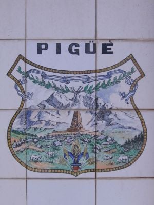
Pigüé, Agricultural settlement in Buenos Aires Province, Argentina
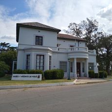
Pigüé is an agricultural city in Buenos Aires Province located about 584 kilometers southwest of the capital. The town follows a regular grid pattern with wide streets and central administrative buildings, reflecting early urban planning principles.
The city was founded in 1884 by French settlers from the Aveyron region who came to Argentina seeking agricultural opportunities. This early settlement shaped the region's development and established its role as a farming center.
Residents maintain their Occitan language heritage through local associations and street names that reflect the city's French roots. This connection to the founding ancestors appears in everyday details and during community gatherings.
The city sits at 293 meters elevation with four distinct seasons that allow for diverse agricultural production throughout the year. Visitors should note that weather patterns and daylight vary significantly by season, affecting how the landscape appears.
The city is home to Argentina's first agricultural cooperative, established in 1898, which shaped the history of the cooperative movement in South America. This institution demonstrates how local initiatives could influence regional and national development.
Location: Saavedra Partido
Inception: December 4, 1884
Elevation above the sea: 293 m
GPS coordinates: -37.60000,-62.40000
Latest update: December 7, 2025 09:20
Ernesto Tornquist Provincial Park
59.6 km
Cerro Ceferino
79.5 km
Plaza Ernesto Tornquist
57.9 km
Estacion De Tren Sierra De La Ventana
80.2 km
Museo Fortín Cuatreros
123.8 km
Parroquia Inmaculado Corazón de María
124.1 km
Jardín botánico Pillahuincó
64 km
Art Museums Mba-Mac
124.5 km
Museum and Archives of the City of Pigüé
1.7 km
Isla La Sistina
70 km
Coleman House (FUNDASUR-CONICET)
124.6 km
Casona Laplacette
107.9 km
Porton De Acceso Ruinas Club Hotel
68.4 km
Adolfo Alsina town hall
56.6 km
Puente Blanco
77.2 km
Palacio Municipal de Guaminí
65.6 km
Cruz del Cementerio de Carhué
58.7 km
Matadero de Villa Epecuén
61 km
Palacio Municipal de Coronel Pringles
101.9 km
Museo Regional Dr. Adolfo Alsina
56.6 km
Cruz de ingreso a la ciudad de Guaminí
64.9 km
Plaza Independencia
87.2 km
Matadero de Saldungaray
85.2 km
Cruz del Cementerio de Tornquist
56.8 km
Cruz del cementerio de Coronel Pringles
103.1 km
Cruz del Cementerio de Coronel Pringles
103 km
Matadero Municipal de Salliquelo
106.1 km
Comandancia del Fuerte Argentino
69 kmVisited this place? Tap the stars to rate it and share your experience / photos with the community! Try now! You can cancel it anytime.
Discover hidden gems everywhere you go!
From secret cafés to breathtaking viewpoints, skip the crowded tourist spots and find places that match your style. Our app makes it easy with voice search, smart filtering, route optimization, and insider tips from travelers worldwide. Download now for the complete mobile experience.
A unique approach to discovering new places❞
— Le Figaro
All the places worth exploring❞
— France Info
A tailor-made excursion in just a few clicks❞
— 20 Minutes