Flores da Cunha

Log in to your account

AroundUs is a community-driven map of interesting places, built by curious explorers like you. It grows with every review, story, and photo you share.
Connect to save your favorite spots, contribute locations, and create personalized routes.
Continue with Google
Continue with Apple
Continue with X
Continue with Facebook
Continue with email
By continuing, you accept our Terms and Conditions and our Privacy Policy
Create an account
Add to collection
Map
Suggest a change
Share

Flores da Cunha, Agricultural municipality in Serra Gaúcha, Brazil.

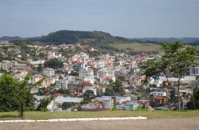
Flores da Cunha is a municipality in Rio Grande do Sul situated at around 750 meters elevation, defined by hillside vineyards and traditional Italian stone houses. The region spans three administrative districts and maintains this distinctive combination of agricultural land and architectural heritage.

The area evolved from the Nova Trento settlement to an independent municipality in 1924, following Italian immigration waves between 1876 and 1892. These periods of settlement established the foundation for the wine industry and regional identity that define the place today.

Italian roots shape daily life here through language, building styles, and local customs that visitors notice walking through the region. The Talian dialect remains spoken in shops and homes, connecting people to their heritage in practical ways.

Numerous wineries throughout the region offer tours and tastings that can be arranged year-round through local contacts. The elevation and hillside terrain require comfortable footwear, and exploring involves some walking across varied slopes.

The region holds status as Brazil's largest wine producer, cultivating varieties like Merlot and Cabernet Sauvignon at an elevation unusual for the country's southern climate. This altitude advantage allows grape growing that would otherwise be uncommon for this part of Brazil.

Location: Rio Grande do Sul

Elevation above the sea: 709 m

Shares border with: Antônio Prado, Caxias do Sul, Farroupilha, Nova Pádua, Nova Roma do Sul, São Marcos

Website: http://floresdacunha.rs.gov.br

GPS coordinates: -29.02889,-51.18194

Latest update: December 22, 2025 14:49

Photos
Reviews

Visited this place? Tap the stars to rate it and share your experience / photos with the community! Try now! You can cancel it anytime.

« Flores da Cunha - Agricultural municipality in Serra Gaúcha, Brazil » is provided by Around Us (aroundus.com). Images and texts are derived from Wikimedia project under a Creative Commons license. You are allowed to copy, distribute, and modify copies of this page, under the conditions set by the license, as long as this note is clearly visible.

Discover hidden gems everywhere you go!

From secret cafés to breathtaking viewpoints, skip the crowded tourist spots and find places that match your style. Our app makes it easy with voice search, smart filtering, route optimization, and insider tips from travelers worldwide. Download now for the complete mobile experience.

Around Us App Screenshot

A unique approach to discovering new places

Le Figaro

All the places worth exploring

France Info

A tailor-made excursion in just a few clicks

20 Minutes