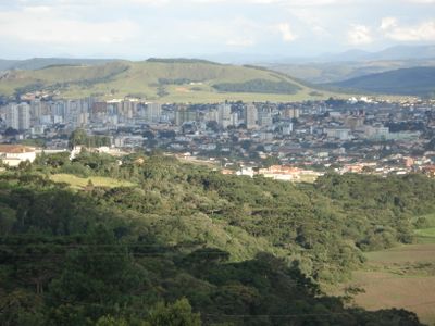
Lages, Administrative center in Santa Catarina, Brazil.
Lages is a municipality in the central highlands of Santa Catarina, set among rolling hills and valleys where pastures alternate with patches of native forest. The downtown streets run between low buildings and small squares, where local shops and markets anchor daily routines.
Settlers established the first camps on this plateau in 1766 as part of the Portuguese push into the southern interior. Cattle ranching and trade routes became the economic foundation of the region during the 19th century.
Rodeo events in Lages display the everyday skills of local cattle ranchers and horsemen, reflecting the deep ties between rural work and community life. Visitors watch competitions that bring together families and show how ranching shapes the character of the area.
Several highways lead to the center and connect the city to other towns across Santa Catarina, while regular bus lines organize regional traffic. Visitors find hotels and guesthouses near the main avenues, which also provide access to restaurants and shops.
The forests around the city shelter Araucaria trees with thick trunks and umbrella-shaped crowns, which once covered much of the highland. Local dishes use the seeds of these trees, gathered in winter and prepared in traditional ways.
Location: Santa Catarina
Inception: 1766
Elevation above the sea: 919 m
Shares border with: Bocaina do Sul, Correia Pinto, Painel, São Joaquim, Capão Alto, Bom Jesus, Campo Belo do Sul, Otacílio Costa, Palmeira, São José do Cerrito
Website: http://lages.sc.gov.br
GPS coordinates: -27.81583,-50.32583
Latest update: December 13, 2025 15:44
Memorial Nereu Ramos
67 mParque Natural Municipal de Lages
4.1 kmEscola Evangélica e Igreja Presbiteriana
410 mPalacete Gamborgi
311 mMuseu Malinverni Filho
367 mScenic viewpoint
27.4 kmScenic viewpoint
18 kmPolícia Rodoviária Federal Lages
15.4 kmWork of art, sculpture
31 kmRepresa Rio Caveiras
14.8 kmScenic viewpoint
15.3 kmScenic viewpoint
18.7 kmGarganta do Diabo
18.1 kmCentro Cultural Vidal Ramos
153 mScenic viewpoint
16.9 kmPolícia Rodoviária Federal
33.4 kmScenic viewpoint
17.4 kmScenic viewpoint
18.7 kmScenic viewpoint
4.3 kmFoto bonita
41.4 kmFoto 2
51.8 kmCascata Fazenda Grande
29.9 kmWaterfall
21.1 kmWaterfall
8.5 kmWaterfall
9.4 kmWaterfall
8.5 kmWaterfall
8.5 kmVisited this place? Tap the stars to rate it and share your experience / photos with the community! Try now! You can cancel it anytime.
Discover hidden gems everywhere you go!
From secret cafés to breathtaking viewpoints, skip the crowded tourist spots and find places that match your style. Our app makes it easy with voice search, smart filtering, route optimization, and insider tips from travelers worldwide. Download now for the complete mobile experience.
A unique approach to discovering new places❞
— Le Figaro
All the places worth exploring❞
— France Info
A tailor-made excursion in just a few clicks❞
— 20 Minutes