Paraibuna, Municipality in Vale do Paraíba region, São Paulo, Brazil
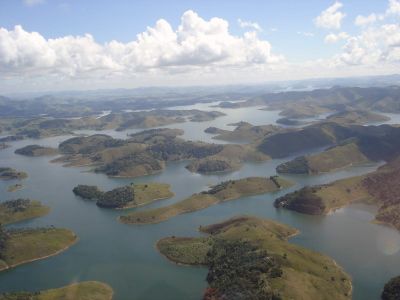
Paraibuna is a municipality in the Vale do Paraíba region of São Paulo state, spreading across roughly 809 square kilometers at an elevation of about 635 meters. The area is marked by rivers, forests, and farmland that shape the landscape of southeastern Brazil.
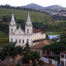
The settlement started in 1666 with a chapel dedicated to Saint Anthony and gained official parish status in 1812. Coffee farming shaped economic growth between 1830 and 1870, driving the community's development during that period.
The place has deep roots in farming, with locals long engaged in coffee cultivation, then shifting to cotton, and finally establishing dairy farming as the main economic focus. This connection to agricultural work continues to shape daily life and community identity.
The area can be reached via the President Dutra Freeway and Tamoios Highway, offering direct connections to larger cities in São Paulo state. Visitors should know that local services follow a rural pace, so it is best to plan activities with the day's rhythm in mind.
The construction of the Paraibuna-Paraitinga Dam in the 1960s dramatically altered the local landscape by flooding fertile farmland. This transformation left a lasting impact on how the community is organized and how people live today.
Location: São Paulo
Elevation above the sea: 635 m
Shares border with: Jacareí, Natividade da Serra, Caraguatatuba, Jambeiro, Redenção da Serra, Salesópolis, Santa Branca
Website: http://paraibuna.sp.gov.br
GPS coordinates: -23.38611,-45.66222
Latest update: December 7, 2025 10:04
Boiçucanga
44.7 km
Estádio Martins Pereira
30.6 km
Brazilian Aerospace Memorial
27.2 km
Anthropology Museum of the Paraíba Valley
32.9 km
Praia da Baleia
43.4 km
Boracéia Biological Station
34.5 km
Deuses e Faraós Restaurante
31.4 km
Dr. Oswaldo Cruz
40.4 km
Museu Interativo de Ciências
30.3 km
Nestle do Brasil
30.7 km
Phare de Ponta das Canas
50.2 km
Casa do Ajudante Braga
22.7 km
Museu Paulista de Antiguidades Mecânicas
31.8 km
Museu de Esportes de São José dos Campos
30.7 km
São Dimas Cathedral
31.1 km
Capela Nossa Senhora da Ajuda
36.9 km
Beco Da Mulher Maravilha
46 km
Capela Nossa Senhora das Mercês
40.3 km
Sanatório Vicentina Aranha
31.8 km
Convento Franciscano de Nossa Senhora do Amparo
49 km
Bica de Paraibuna
266 m
Igreja Matriz de São Luiz do Paraitinga
40.3 km
Antiga Sede da Prefeitura de Redenção da Serra
18.4 km
Paço Municipal
32.1 km
Capela de São Miguel
32 km
PP-ZDF
31.3 km
Antenna testing facility, INPE
28 km
Santos-Dumont 14-bis replica at Parque Santos Dumont
31.3 kmVisited this place? Tap the stars to rate it and share your experience / photos with the community! Try now! You can cancel it anytime.
Discover hidden gems everywhere you go!
From secret cafés to breathtaking viewpoints, skip the crowded tourist spots and find places that match your style. Our app makes it easy with voice search, smart filtering, route optimization, and insider tips from travelers worldwide. Download now for the complete mobile experience.
A unique approach to discovering new places❞
— Le Figaro
All the places worth exploring❞
— France Info
A tailor-made excursion in just a few clicks❞
— 20 Minutes