Chest opened
+${chestReward.xp} XP
Explorer
NOUVEAU ×${chestReward.collectible.quantity}
tapez pour fermer
Chest locked

Open chests in the app

Around Us is built for your phone — chests unlock when you walk, explore and capture nearby places.

Enable Location

We need your location to show you interesting places around you

Discover nearby places

Find interesting locations and hidden gems around you

Precise directions

Get accurate directions and distances to places

Your location is never shared with other users. It's only used when you tap the location button.

Ituiutaba

Log in to your account

Start exploring — it's free

Trusted by 72,887 travelers worldwide

Continue with Google
Continue with Apple
or

We will send you a code to connect

By continuing, you accept our Terms and Conditions and our Privacy Policy

Check your inbox

We've sent a pincode in your inbox. Please enter the code below.

Discussion Reviews 2 Photos
51.8k Popularity

Ituiutaba, Administrative municipality in Minas Gerais, Brazil

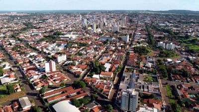
Ituiutaba is an administrative municipality in western Minas Gerais situated at about 587 meters in elevation. The city covers approximately 2,694 square kilometers and features a mix of urban and rural areas across its territory.

The settlement began in 1820 as Arraial de São José do Tijuco and was renamed Vila Platina in 1901. It took its current name Ituiutaba in 1917, marking a shift in the community's identity as it grew.

The Brotherhood of St. Benedict has organized traditional Congado celebrations since 1957, bringing the community together through music and processions. These events remain a central part of how locals mark their cultural identity and maintain their heritage.

The city operates 54 health facilities and 39 primary schools serving the population. Sewage systems are fully connected throughout urban residential areas, showing solid infrastructure coverage.

The climate features distinct wet and dry seasons with temperatures ranging from around 14 degrees Celsius in June to 31 degrees in December. This seasonal shift shapes the rhythm of the year and influences agricultural activities throughout the region.

The community of curious travelers

AroundUs brings together thousands of curated places, local tips, and hidden gems, enriched daily by 60,000 contributors worldwide.

Start exploring
Location
Elevation above the sea
587 m
Shares border with
Gurinhatã, Monte Alegre de Minas, Prata, Cachoeira Dourada, Campina Verde, Canápolis, Capinópolis, Inaciolândia, Ipiaçu
Address
Ituiutaba, MG, Brazil
GPS coordinates
-18.96889,-49.46500
Latest update
December 14, 2025 18:13
Reviews
Share your experience

No review yet

Discussions
Start a discussion...

No discussion yet

« Ituiutaba - Administrative municipality in Minas Gerais, Brazil » is provided by Around Us (aroundus.com). Images and texts are derived from Wikimedia project under a Creative Commons license. You are allowed to copy, distribute, and modify copies of this page, under the conditions set by the license, as long as this note is clearly visible.

Discover hidden gems everywhere you go!

From secret cafés to breathtaking viewpoints, skip the crowded tourist spots and find places that match your style. Our app makes it easy with voice search, smart filtering, route optimization, and insider tips from travelers worldwide. Download now for the complete mobile experience.

Around Us App Screenshot

A unique approach to discovering new places

Le Figaro

All the places worth exploring

France Info

A tailor-made excursion in just a few clicks

20 Minutes

Around Us
Travel Guide & Maps
Download

Send to your phone

QR Code
1

Open the camera app on your mobile.

2

Point at the QR code with your camera. A notification will appear.

3

Tap the notification to open the link.