Enable Location

We need your location to show you interesting places around you

Discover nearby places

Find interesting locations and hidden gems around you

Precise directions

Get accurate directions and distances to places

Your location is never shared with other users. It's only used when you tap the location button.

Cantagalo

Log in to your account

Start exploring — it's free

Trusted by 62,837 travelers worldwide

Continue with Google
Continue with Apple
or

We will send you a code to connect

By continuing, you accept our Terms and Conditions and our Privacy Policy

Check your inbox

We've sent a pincode in your inbox. Please enter the code below.

Cantagalo, Municipality in Rio de Janeiro State, Brazil

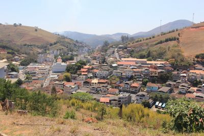
Cantagalo is a municipality in the central-eastern region of Rio de Janeiro State, covering a substantial rural area. The terrain is rolling, shaped by forests and fields used for livestock and small-scale farming.

The settlement started in 1755 when Portuguese nobleman Manoel Henriques came from Minas Gerais seeking gold in this unexplored land. The area later became an important center for farming and livestock raising.

Local residents keep alive traditional crafts and regional festivals that shape daily life in this rural area. The older buildings show architectural styles that reflect the region's colonial roots.

Visitors will find the town center in a manageable area where most shops and services cluster together. The best time to explore is during drier months when roads are easier to travel.

The current name dates to 1786 and comes from an unusual story: a rooster's crow reportedly helped settlers find their lost camp in the region. This tale shapes local identity and is still shared in community stories today.

The community of curious travelers

AroundUs brings together thousands of curated places, local tips, and hidden gems, enriched daily by 60,000 contributors worldwide.

Start exploring
Location
Elevation above the sea
391 m
Shares border with
Carmo, Macuco, São Sebastião do Alto, Cordeiro, Duas Barras, Estrela Dalva, Itaocara, Pirapetinga, Santo Antônio de Pádua
GPS coordinates
-21.98083,-42.36778
Latest update
December 20, 2025 11:44
« Cantagalo - Municipality in Rio de Janeiro State, Brazil » is provided by Around Us (aroundus.com). Images and texts are derived from Wikimedia project under a Creative Commons license. You are allowed to copy, distribute, and modify copies of this page, under the conditions set by the license, as long as this note is clearly visible.

Discover hidden gems everywhere you go!

From secret cafés to breathtaking viewpoints, skip the crowded tourist spots and find places that match your style. Our app makes it easy with voice search, smart filtering, route optimization, and insider tips from travelers worldwide. Download now for the complete mobile experience.

Around Us App Screenshot

A unique approach to discovering new places

Le Figaro

All the places worth exploring

France Info

A tailor-made excursion in just a few clicks

20 Minutes

Around Us
Travel Guide & Maps
Download

Send to your phone

QR Code
1

Open the camera app on your mobile.

2

Point at the QR code with your camera. A notification will appear.

3

Tap the notification to open the link.