Colatina

Log in to your account

AroundUs is a community-driven map of interesting places, built by curious explorers like you. It grows with every review, story, and photo you share.
Connect to save your favorite spots, contribute locations, and create personalized routes.
Continue with Google
Continue with Apple
Continue with X
Continue with Facebook
Continue with email
By continuing, you accept our Terms and Conditions and our Privacy Policy
Create an account
Add to collection
Map
Suggest a change
Share

Colatina, Commercial hub in Espírito Santo, Brazil.

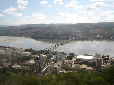
Colatina is a commercial city in Espírito Santo state, Brazil, stretching across both banks of the Rio Doce river. The built environment spreads over gentle hills and flat sections near the water, with residential areas, shops, and public squares occupying different elevations.

Settlement began in the late 16th century with explorations along the Rio Doce by European expeditions. The construction of the first bridge in 1928 permanently connected the two riverbanks and allowed the expansion of urban areas northward.

Residents gather along the riverfront in the early evening to walk and talk as the heat fades, making the banks of the Rio Doce a natural meeting ground. This stretch of water separates older neighborhoods from newer districts on the opposite side and shapes how people move through the city each day.

Federal highways BR-101 and BR-259 lead directly into the city and connect it with Vitória to the south and other regions of the state. Visitors planning to explore the area should note that residential neighborhoods and commercial zones are spread across a wide territory.

The banks of the Rio Doce served for centuries as a boundary between colonized coastal areas and inaccessible rainforest regions further inland. Only with the construction of the bridge could the city assume its role as a passage point to remote stretches of land, which greatly influenced its growth.

Location: Espírito Santo

Inception: December 30, 1921

Elevation above the sea: 71 m

Shares border with: Pancas, São Roque do Canaã, Marilândia, Governador Lindenberg, Baixo Guandu, Itaguaçu, João Neiva, Linhares, São Domingos do Norte

Website: http://colatina.es.gov.br

GPS coordinates: -19.53889,-40.63083

Latest update: December 14, 2025 17:04

Photos
Reviews

Visited this place? Tap the stars to rate it and share your experience / photos with the community! Try now! You can cancel it anytime.

« Colatina - Commercial hub in Espírito Santo, Brazil » is provided by Around Us (aroundus.com). Images and texts are derived from Wikimedia project under a Creative Commons license. You are allowed to copy, distribute, and modify copies of this page, under the conditions set by the license, as long as this note is clearly visible.

Discover hidden gems everywhere you go!

From secret cafés to breathtaking viewpoints, skip the crowded tourist spots and find places that match your style. Our app makes it easy with voice search, smart filtering, route optimization, and insider tips from travelers worldwide. Download now for the complete mobile experience.

Around Us App Screenshot

A unique approach to discovering new places

Le Figaro

All the places worth exploring

France Info

A tailor-made excursion in just a few clicks

20 Minutes